 |
|
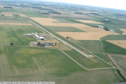 |
(Click on the photo to enlarge) |
Location & QuickFacts
| FAA Information Effective: | 2008-09-25 |
| Airport Identifier: | OWX |
| Airport Status: | Operational |
| Longitude/Latitude: | 083-58-55.3000W/41-02-08.1000N
-83.982028/41.035583 (Estimated) |
| Elevation: | 764 ft / 232.87 m (Surveyed) |
| Land: | 15 acres |
| From nearest city: | 3 nautical miles NE of Ottawa, OH |
| Location: | Putnam County, OH |
| Magnetic Variation: | 05W (1990) |
Owner & Manager
| Ownership: | Publicly owned |
| Owner: | Putman Co Arpt Authority |
| Address: | Po Box 263
Ottawa, OH 45875 |
| Phone number: | 419-523-3910 |
| Manager: | Kenneth Decker |
| Address: | P O Box 263
Ottawa, OH 45875
523 N. WALNUT ST; OTTAWA, OH 45875. |
| Phone number: | 419-523-3910 |
Airport Operations and Facilities
| Airport Use: | Open to public |
| Wind indicator: | Yes |
| Segmented Circle: | No |
| Control Tower: | No |
| Lighting Schedule: | DUSK-DAWN
ACTVT HIRL RY 09/27 & REIL RYS 09 27 - CTAF. |
| Beacon Color: | Clear-Green (lighted land airport) |
| Landing fee charge: | No |
| Sectional chart: | Detroit |
| Region: | AGL - Great Lakes |
| Boundary ARTCC: | ZOB - Cleveland |
| Tie-in FSS: | CLE - Cleveland |
| FSS on Airport: | No |
| FSS Toll Free: | 1-800-WX-BRIEF |
| NOTAMs Facility: | CLE (NOTAM-d service avaliable) |
| Federal Agreements: | N |
Airport Communications
| CTAF: | 122.700 |
| Unicom: | 122.700 |
Airport Services
| Fuel available: | 100LLA |
| Airframe Repair: | MINOR |
| Power Plant Repair: | MINOR |
| Bottled Oxygen: | NONE |
| Bulk Oxygen: | NONE |
Runway Information
Runway 09/27
| Dimension: | 4427 x 65 ft / 1349.3 x 19.8 m |
| Surface: | ASPH, Fair Condition |
| Edge Lights: | High |
| |
Runway 09 |
Runway 27 |
| Longitude: | 083-59-24.1996W | 083-58-26.4396W |
| Latitude: | 41-02-07.9819N | 41-02-08.2003N |
| Elevation: | 754.00 ft | 764.00 ft |
| Alignment: | 90 | 127 |
| Traffic Pattern: | Left | Left |
| Markings: | Non-precision instrument, Fair Condition | Non-precision instrument, Fair Condition |
| VASI: | | 2-light PAPI on left side |
| Runway End Identifier: | Yes
OTS INDEFLY. | Yes |
| Obstruction: | 15 ft road, 201.0 ft from runway, 217 ft left of centerline
+15 FT RD 0-200 FT FM RY END 208 FT L. | 30 ft pline, 201.0 ft from runway, 225 ft right of centerline
30 FT PLINE 0-200 FT FM RY 240 FT R; 15 FT RD 0-200 FT FM RY 208 FT R. |
|
Radio Navigation Aids
| ID |
Type |
Name |
Ch |
Freq |
Var |
Dist |
| PDR | NDB | Ottawa | | 233.00 | 05W | 0.4 nm |
| BNR | NDB | Benton Ridge | | 334.00 | 05W | 14.2 nm |
| LYL | NDB | Lima | | 362.00 | 04W | 20.0 nm |
| DFI | NDB | Defiance | | 246.00 | 05W | 27.0 nm |
| FZI | NDB | Fostoria | | 379.00 | 05W | 28.1 nm |
| VFU | NDB | Stanley | | 411.00 | 05W | 30.5 nm |
| BYN | NDB | Bryan | | 260.00 | 04W | 34.5 nm |
| USE | NDB | Fulton | | 375.00 | 05W | 35.1 nm |
| TII | NDB | Tiffin | | 269.00 | 05W | 35.3 nm |
| RUV | NDB | Rushsylvania | | 326.00 | 05W | 37.5 nm |
| EDJ | NDB | Bellefontaine | | 242.00 | 05W | 40.7 nm |
| CQA | NDB | Lakefield | | 205.00 | 04W | 42.5 nm |
| MNN | NDB | Marion | | 201.00 | 05W | 48.5 nm |
| TOL | TACAN | Toledo | 072X | | 05W | 34.5 nm |
| MAH | VOR | Marathon | | 114.90 | 05W | 14.5 nm |
| AOH | VOR | Allen County | | 108.40 | 04W | 19.8 nm |
| BUD | VOR | Buckeye | | 109.80 | 05W | 48.8 nm |
| VWV | VOR/DME | Waterville | 078X | 113.10 | 02W | 29.4 nm |
| FDY | VORTAC | Findlay | 019X | 108.20 | 02W | 11.3 nm |
| ROD | VORTAC | Rosewood | 122X | 117.50 | 05W | 45.0 nm |
Remarks
- INTENSIVE AGRI OPNS & CROP DUSTING.
- EXTENSIVE GLIDER OPNS.
- PAEW INVOF RAMP INDEFLY.
- WINDSOCK OTS INDEFLY.
Images and information placed above are from
http://www.airport-data.com/airport/OWX/
We thank them for the data!
| General Info
|
| Country |
United States
|
| State |
OHIO
|
| FAA ID |
OWX
|
| Latitude |
41-02-08.097N
|
| Longitude |
083-58-55.288W
|
| Elevation |
763 feet
|
| Near City |
OTTAWA
|
We don't guarantee the information is fresh and accurate. The data may
be wrong or outdated.
For more up-to-date information please refer to other sources.
|
|


