 |
|
| Portage County Regional Airport |
| IATA: 29G – ICAO: none |
| Summary |
| Airport type |
Public |
| Operator |
Portage County Regional Airport Authority |
| Location |
Ravenna, Ohio |
| Elevation AMSL |
1,197 ft / 365 m |
| Coordinates |
41°13′1″N 81°15′10″W / 41.21694°N 81.25278°W / 41.21694; -81.25278Coordinates: 41°13′1″N 81°15′10″W / 41.21694°N 81.25278°W / 41.21694; -81.25278 |
| Runways |
| Direction |
Length |
Surface |
| ft |
m |
| 27/9 |
3,500 |
1,067 |
Asphalt |
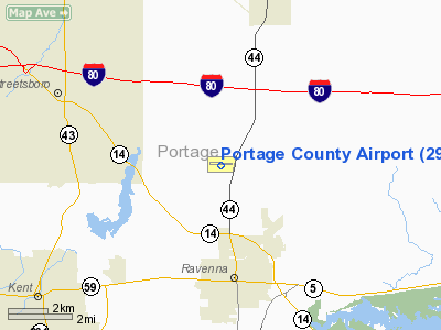
Portage County Regional Airport is a public airport located in Shalersville Township near Ravenna, Ohio, USA.
The above content comes from Wikipedia and is published under free licenses – click here to read more.
Location & QuickFacts
| FAA Information Effective: | 2008-09-25 |
| Airport Identifier: | 29G |
| Airport Status: | Operational |
| Longitude/Latitude: | 081-15-05.8505W/41-12-36.6559N
-81.251625/41.210182 (Estimated) |
| Elevation: | 1197 ft / 364.85 m (Estimated) |
| Land: | 76 acres |
| From nearest city: | 3 nautical miles N of Ravenna, OH |
| Location: | Portage County, OH |
| Magnetic Variation: | 04W (1965) |
Owner & Manager
| Ownership: | Publicly owned |
| Owner: | Portage Co Arpt Auth. |
| Address: | 8095 State Route 44
Ravenna, OH 44266 |
| Phone number: | 330-297-1478 |
| Manager: | P Russell Machamer |
| Address: | 4039 Nanway Blvd
Ravenna, OH 44266
C/O CASTLE AVIATION. |
| Phone number: | 330-296-5563 |
Airport Operations and Facilities
| Airport Use: | Open to public |
| Wind indicator: | Yes |
| Segmented Circle: | No |
| Control Tower: | No |
| Lighting Schedule: | DUSK-DAWN
ACTVT MIRL RY 09/27; REIL RYS 09 & 27 & PAPI RY 27 - CTAF. |
| Beacon Color: | Clear-Green (lighted land airport) |
| Landing fee charge: | No |
| Sectional chart: | Detroit |
| Region: | AGL - Great Lakes |
| Boundary ARTCC: | ZOB - Cleveland |
| Tie-in FSS: | CLE - Cleveland |
| FSS on Airport: | No |
| FSS Toll Free: | 1-800-WX-BRIEF |
| NOTAMs Facility: | CLE (NOTAM-d service avaliable) |
| Federal Agreements: | N |
Airport Communications
| CTAF: | 123.050 |
| Unicom: | 123.050 |
Airport Services
| Fuel available: | 100LLA |
| Bottled Oxygen: | NONE |
| Bulk Oxygen: | NONE |
Runway Information
Runway 09/27
| Dimension: | 3500 x 75 ft / 1066.8 x 22.9 m |
| Surface: | ASPH, Fair Condition |
| Edge Lights: | Medium |
| |
Runway 09 |
Runway 27 |
| Longitude: | 081-15-28.6594W | 081-14-43.0414W |
| Latitude: | 41-12-35.1754N | 41-12-38.1352N |
| Elevation: | 1194.00 ft | 1192.00 ft |
| Alignment: | 85 | 127 |
| Traffic Pattern: | Left | Left |
| Markings: | Non-precision instrument, Poor Condition
09/27 MARKINGS POOR-WEATHERED. | Non-precision instrument, Poor Condition |
| VASI: | | 4-light PAPI on left side |
| Runway End Identifier: | Yes | Yes |
| Centerline Lights: | No | No |
| Touchdown Lights: | No | No |
| Obstruction: | 32 ft trees, 752.0 ft from runway, 147 ft left of centerline, 17:1 slope to clear | , 50:1 slope to clear |
|
Radio Navigation Aids
| ID |
Type |
Name |
Ch |
Freq |
Var |
Dist |
| AK | NDB | Akron | | 362.00 | 07W | 10.4 nm |
| BKL | NDB | Burke Lakefront | | 416.00 | 07W | 26.7 nm |
| EZE | NDB | Engel | | 226.00 | 07W | 27.1 nm |
| LQL | NDB | Lakeland | | 263.00 | 08W | 29.0 nm |
| HBD | NDB | Hubbard | | 408.00 | 08W | 32.8 nm |
| CL | NDB | Harri | | 344.00 | 07W | 33.1 nm |
| UCP | NDB | Castle | | 272.00 | 09W | 39.5 nm |
| TSO | NDB | Tolson | | 395.00 | 07W | 39.7 nm |
| AAU | NDB | Ashland | | 329.00 | 07W | 47.7 nm |
| MLR | NDB | Millersburg/dcmsnd | | 382.00 | 06W | 49.1 nm |
| ACO | VOR/DME | Akron | 091X | 114.40 | 04W | 6.6 nm |
| CXR | VOR/DME | Chardon | 074X | 112.70 | 05W | 18.9 nm |
| LNN | VOR/DME | Lost Nation | 039X | 110.20 | 08W | 29.2 nm |
| BSV | VOR/DME | Briggs | 071X | 112.40 | 04W | 29.4 nm |
| JFN | VOR/DME | Jefferson | 099X | 115.20 | 05W | 40.1 nm |
| DJB | VOR/DME | Dryer | 083X | 113.60 | 05W | 42.1 nm |
| YNG | VORTAC | Youngstown | 027X | 109.00 | 05W | 27.1 nm |
| CAK | VOT | Akron/canton Regional | | 110.60 | | 19.7 nm |
| CLE | VOT | Cleveland | | 110.40 | | 29.5 nm |
Remarks
- ALL AREAS OFF RWY SFC SOFT WHEN WET OR THAWING
- DEER ON AND INVOF ARPT.
- PAEW ON TWY & RAMPS INDEFLY.
- PARAGLIDER OPS BY PERMIT ONLY.
Images and information placed above are from
http://www.airport-data.com/airport/29G/
We thank them for the data!
| General Info
|
| Country |
United States
|
| State |
OHIO
|
| FAA ID |
29G
|
| Latitude |
41-12-36.702N
|
| Longitude |
081-15-05.871W
|
| Elevation |
1197 feet
|
| Near City |
RAVENNA
|
We don't guarantee the information is fresh and accurate. The data may
be wrong or outdated.
For more up-to-date information please refer to other sources.
|
|


