|
 |
|
||||
|
Coordinates: 39°59′53″N 082°53′31″W / 39.99806°N 82.89194°W
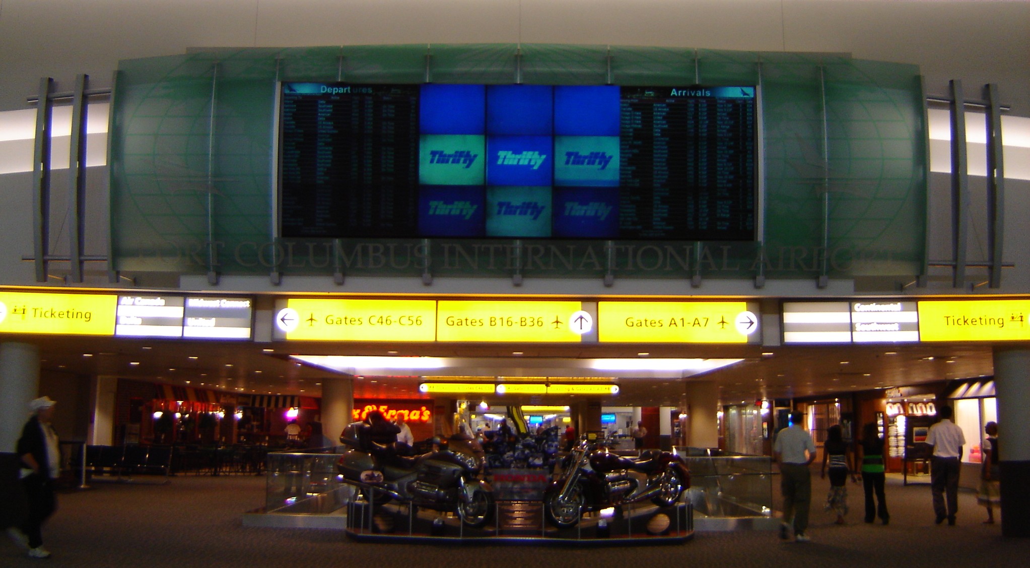
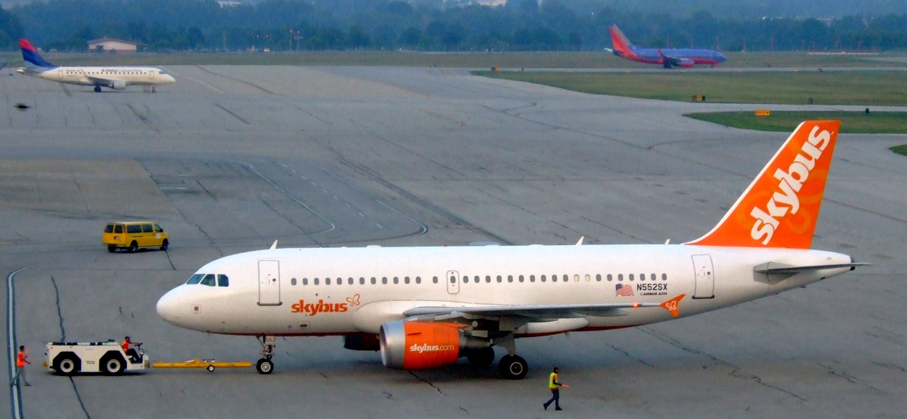
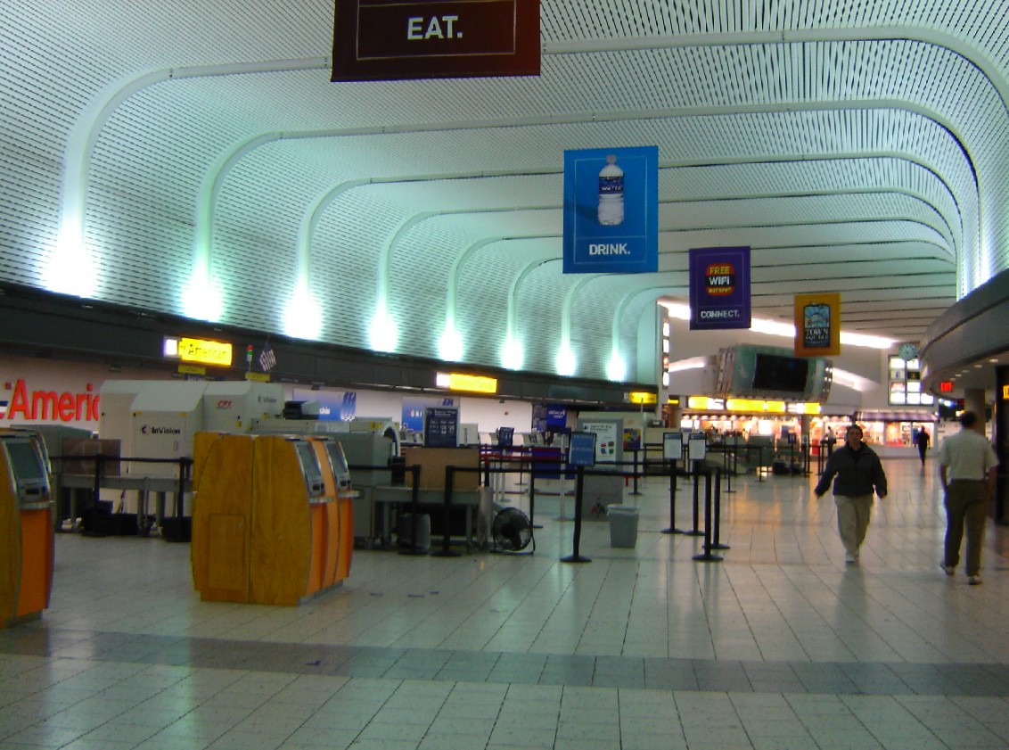
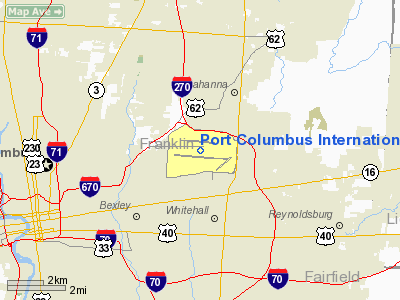
Port Columbus International Airport (IATA: CMH, ICAO: KCMH, FAA LID: CMH), commonly shortened to Port Columbus, is an international airport located 6 miles (10 kilometers) east of downtown Columbus, Ohio, USA. It is managed by the Columbus Regional Airport Authority, which also oversees operations at Rickenbacker International Airport and Bolton Field. The airport code 'CMH' stands for "Columbus Municipal Hangar," though that name is no longer used today. Port Columbus is primarily a passenger airport, providing over 190 non-stop flights to 44 airports via 15 airlines daily. Traffic reached 7,719,340 passengers in 2007, a 14.6% increase over the previous year. The airport experienced a 13.4% increase in traffic in the first seven months of 2007 and a 23% increase in passengers for the month of July, due to an increase in flights by established carriers as well as the addition of JetBlue and Skybus Airlines (which ceased operations in April 2008). Port Columbus was expected to top 8 million travelers by the end of 2007. According to a 2005 market survey, Port Columbus attracts about 50% of its passengers from outside of its 60 mile radius primary service region. In addition, the airport also handles freight and US mail, with 10,411,920 units of freight and 8,537,279 units of mail passing through in 2006. Today, Port Columbus provides commercial air service to almost all major airport hubs across the United States, with notable exceptions being San Francisco, and Seattle. The airport is the largest passenger airport in the central Ohio region and is the second busiest in the state after Cleveland Hopkins International Airport (Greater Cincinnati/Northern Kentucky International Airport operates more flights than Port Columbus but is located outside of Ohio in Northern Kentucky.). Port Columbus was also the 52 busiest airport in the United States in 2006. Accessing Port Columbus by road is possible by either of two bordering interstate highways: I-270 to the northeast and I-670 to the west. The main airport roadway, International Gateway, connects directly to I-670, making navigating to the airport relatively simple from anywhere in the area. Port Columbus is also known for displaying a large amount of community artwork, including children's drawings, a photographic timeline, and other donated items. Most recognized is Brushstrokes in Flight, a sculpture located directly in front of the Concourse B security checkpoint and designed by Roy Lichtenstein. History
Early historyThe airport opened July 8, 1929, on a site originally selected by Charles Lindbergh, as the eastern air terminus of the Transcontinental Air Transport air-rail New York to Los Angeles intercontinental route. Passengers traveled overnight on the Pennsylvania Railroad's luxury Airway Limited from New York to Columbus; by air from Columbus to Waynoka, Oklahoma; by rail again from Waynoka to Clovis, New Mexico; and finally by air from Clovis to Los Angeles. The original terminal building and hangars still exist and are in use; the former terminal has been restored and is used for rental office space, while the original hangars are still used for airport operations. By 1939, Port Columbus was handling fourteen flights per day. Ten of these flights were Transcontinental and Western Airlines (predecessor of Trans World Airlines), while the other four were American Airlines. TWA averaged twenty-one passengers per day at this time.
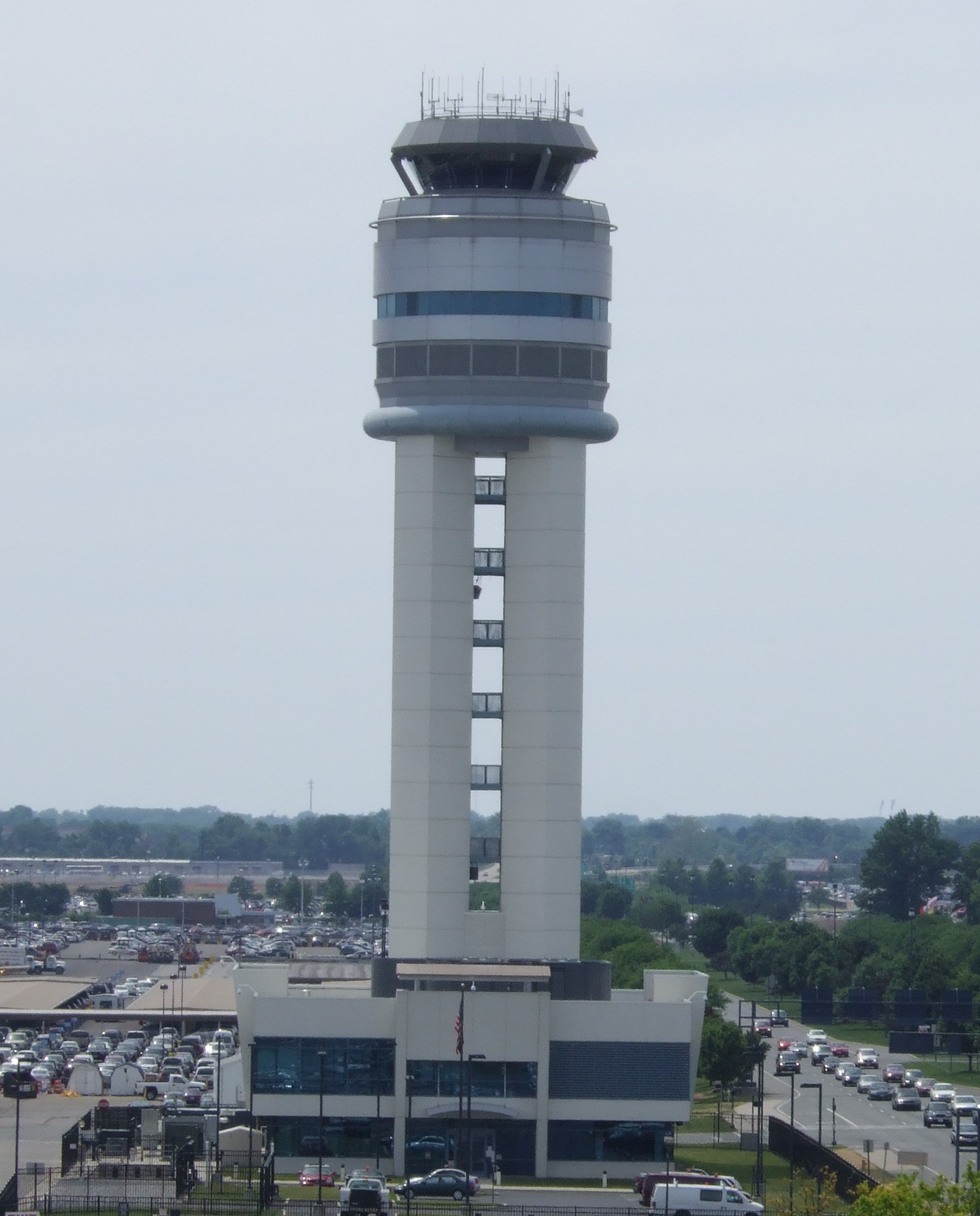
Recent improvementsA $70 million renovation of airport facilities was completed in 1979 for the airport's 50th anniversary. This upgraded the airport's capacity to 250 flights per day and added fully enclosed jetways at every gate. Ten years later in 1989, a second, $15.5 million, seven-gate concourse was dedicated. The concourse was used exclusively by US Airways at the time. A third concourse was completed in 1995, which is now Concourse C. Between 1998 and 2000, numerous airport expansion and renovation projects were completed, including a $25 million terminal renovation in 1998 that included additional retail shops, new flight information displays, enhanced lighting, upgraded flooring, and a new food court. Also, new hangars and office spaces were completed for NetJets in 1999, as well as a $92 million parking garage including an underground terminal entrance, new rental car facilities, dedicated ground transportation area, improved eight-lane terminal access on two levels, and a new atrium and entrances in 2000. On April 25, 2004, a new 195-foot (59 m) control tower directed its first aircraft, ushering in the beginning of several major facility enhancements to be constructed through 2025. Infrastructure
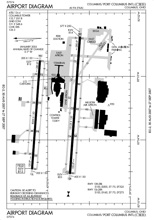
On-site facilitiesIn 2001, Executive Jet Aviation (now known as NetJets Inc.) opened up a 200,000-square-foot (18,580 m²) operational headquarters at Port Columbus International Airport. In November 2006, Skybus Airlines began leasing 100,000 square feet (9,290 m²) of office and hangar facilities at the Columbus International AirCenter adjacent to Port Columbus. American Eagle Airlines operates a maintenance base at Port Columbus, along with Republic Airways who operate their flagship base at Port Columbus. AirfieldThe original 1929 layout for the airport covered 524 acres (212 ha), with two runways extending 2,500 feet (760 m) and 3,500 feet (1,070 m) in length. Since then, the runways have been expanded significantly. In 1952, the current south runway was lengthened to 8,000 feet (2,400 m), making it the longest runway in the midwest at the time. The north runway was also extended to 8,000 feet (2,400 m) in 1997, though the south runway has since been extended to 10,125 feet (3,086 m). Port Columbus international Airport covers 2,185 acres (884 ha) and has two runways:
Runway 10L/28R lies immediately north of the 40th Parallel North, and the line of latitude also goes through the northern edge of the terminal building. AircraftFor the 12-month period ending December 31, 2005, the airport had 216,724 aircraft operations, an average of 593 per day: 46% air taxi, 29% general aviation, 24% scheduled commercial, and 1% military. There are 93 aircraft based at this airport: 46% single engine, 16% multi-engine, 37% jet aircraft, and 1% helicopters. Terminals, airlines and destinations
The first major airline to fly into Port Columbus was TWA, and it kept a presence at Columbus over seventy years during the era of airline regulation. TWA offered a club for exclusive passengers up until 2000 when America West took over a gate held by TWA and the club itself due to financial problems. Port Columbus International Airport was formerly a hub of America West Airlines in the 1990s, but the company closed the hub in 2003. America West eliminated the Columbus hub as result of financial losses at the hub, overall financial losses at the airline, and a weak airline market after September 11, 2001. The airport was the home base of short-lived Skybus Airlines, which began operations from Port Columbus on May 22, 2007. The airline touted themselves as the cheapest airline in the United States, offering a minimum of ten seats for $10 each on every flight. Skybus ceased operations April 4, 2008. Port Columbus International Airport has 3 airport terminals, which contain 44 gates total: Concourse A (gates A1 - A7), Concourse B (gates B15 - B18A, B18B, B19 - B30A, B30B, B31 - B34A, B35B, B35, B36), and Concourse C (gates C46 - C53A, C53B, C54 - C56).
Incidents and accidentsJune 27, 1954An American Airlines Convair CV-240 (N94263) from Dayton International Airport was on approach to Runway 27 at 300 feet when the left side of the plane collided with a US Navy Beechcraft SNB-2C Navigator (BuA23773), also on approach. The Convair recovered and landed, though the nose gear collapsed on landing. The Beechcraft crashed short of the runway, killing two onboard. The probable cause was attributed to "A traffic control situation created by the tower local controller which he allowed to continue without taking the necessary corrective action. A contributing factor was the failure of both crews to detect this situation by visual and/or aural vigilance." January 7, 1990A Piper Aztec from Duluth, Minnesota, veered off the left side of the runway when the nose gear collapsed on landing. The aircraft was damaged significantly, though the pilot survived. The pilot reported having difficulty with the landing gear during taxi from Duluth, and witnesses reported seeing the nose gear of the aircraft canted 60 degrees left during landing. The probable cause was attributed to "Pilot's inadequate preflight of the airplane and the continued operation of the airplane with a nose gear steering problem." July 1, 1991A New Creations Learjet 25XR (N458J) from Philadelphia International Airport lost sight of the runway on approach in heavy rain and lost directional control, resulting in no fatalities. The probable cause was attributed to "The failure of the pilot to maintain visual reference with the runway during a landing, which resulted in a loss of directional control. Also causal to the accident was the pilot's failure to initiate a go-around, after he lost sight of the runway during the touchdown. Factors related to the accident were the heavy rain and the lack of runway centerline lights." January 7, 1994An Atlantic Coast Airlines/United Express BAe Jetstream 41 (N304UE) was on approach to runway 28L when it entered into a stall at 430 feet above runway level. The aircraft collided with a stand of trees and came to rest inside a commercial building 1.2 miles short of the runway and burst into flames. The accident killed two of three crewmembers and five of nine passengers. The probable cause was attributed to "(1) An aerodynamic stall that occurred when the flight crew allowed the airspeed to decay to stall speed following a very poorly planned and executed approach characterized by an absence of procedural discipline; (2) Improper pilot response to the stall warning, including failure to advance the power levers to maximum, and inappropriately raising the flaps; (3) Flight crew experience in 'glass cockpit' automated aircraft, aircraft type and in seat position, a situation exacerbated by a side letter of agreement between the company and its pilots; and (4) the company's failure to provide adequate stabilized approach criteria, and the FAA's failure to require such criteria. Member Vogt concluded that the last factor was contributory but not causal to the accident. Additionally, for the following two factors, Chairman Hall and Member Lauber concluded that they were causal to the accident, while Members Vogt and Hammerschmidt concluded they were contributory to the accident: (5) The company's failure to provide adequate crew resource management training, and the FAA's failure to require such training; and (6) the unavailability of suitable training simulators that precluded fully effective flight crew training." February 16, 1999America West Airlines flight 2811, an Airbus A320 (N628AW), experienced a landing gear malfunction during approach to CMH. After visual confirmation of the fault from the ground, the pilot initiated a missed approach and declared an emergency. On the second approach, the plane landed. Damage was limited to the nose landing gear rims and tires. The incident was very similar to the more recent JetBlue Airways Flight 292. May 2, 1999During taxiing, a Cessna 172 accidentally entered a perimeter road instead of Taxiway Charlie. After turning onto the road, the Cessna struck a fence with its left wing. Investigation revealed that the perimeter road was unmarked. The probable cause was attributed to "The pilot's failure to maintain obstacle clearance and his visual perception of the perimeter road as Taxiway Charlie. A factor in the accident was the absence of a sign identifying the perimeter road." AccessibilityCarThe airport is accessible directly by taking exit number nine on Interstate 670 to International Gateway. Alternately, drivers located south of the airport can also get to the airport via Hamilton Road, just south of Interstate 270, and enter at Sawyer Road. Parking is available long-term and short-term in the six-story attached parking garage, though the first two levels are dedicated to rental cars. Additional long-term parking is also available in two outdoor lots along International Gateway, named blue and red. Both lots access the terminal via a free shuttle, which runs continuously throughout the day. Additionally, there is a small "cell phone lot" accessed from the outbound side of International Gateway. BusPort Columbus can be accessed by bus via the Central Ohio Transit Authority (COTA). Two routes are offered to and from the airport, route 92 which serves the east side of Columbus throughout the day and route 52 which serves Ohio State University during school breaks. Those wishing to take the bus from other regions of central Ohio to the airport must take other busses and transfer to either route. TaxiInbound taxi services are offered through numerous taxi businesses in the Columbus area. All outbound taxi services, however, are offered through Dulles Airport Taxi, Inc. Airport shuttleShuttle services are offered every twenty minutes taking passengers to the heart of Downtown Columbus. Other shuttle services transport passengers to other directions other than downtown. The above content comes from Wikipedia and is published under free licenses – click here to read more.
Location & QuickFacts
Owner & Manager
Airport Operations and Facilities
Airport Communications
Airport Services
Runway InformationRunway 10L/28R
Runway 10R/28L
Radio Navigation Aids
Remarks
Images and information placed above are from We thank them for the data!
We don't guarantee the information is fresh and accurate. The data may
be wrong or outdated.
|
||||||||||||||||||||||||||||||||||||||||||||||||||||||||||||||||||||||||||||||||||||||||||||||||||||||||||||||||||||||||||||||||||||||||||||||||||||||||||||||||||||||||||||||||||||||||||||||||||||||||||||||||||||||||||||||||||||||||||||||||||||||||||||||||||||||||||||||||||||||||||||||||||||||||||||||||||||||||||||||||||||||||||||||||||||||||||||||||||||||||||||||||||||||||||||||||||||||||||||||||||||||||||||||||||||||||||||||||||||||||||||||||||||||||||||||||||||||||||||||||||||||||||||||||||||||||||||||||||||||||||||||||||||||||||||||||||||||||||||||||||||||||||||||||||||||||||||||||||||||||||||||||||||||||||||||

 |
|
Copyright 2004-2026 © by Airports-Worldwide.com, Vyshenskoho st. 36, Lviv 79010, Ukraine Legal Disclaimer |