 |
|
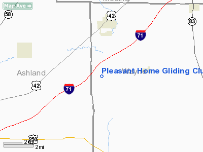
Pleasant Home Gliding Club Gliderport Airport |
Location & QuickFacts
| FAA Information Effective: | 2008-09-25 |
| Airport Identifier: | 14OI |
| Airport Status: | Operational |
| Longitude/Latitude: | 082-06-50.5500W/40-55-09.2020N
-82.114042/40.919223 (Estimated) |
| Elevation: | 1050 ft / 320.04 m (Surveyed) |
| Land: | 0 acres |
| From nearest city: | 1 nautical miles NW of Pleasant Home, OH |
| Location: | Wayne County, OH |
| Magnetic Variation: | 06W (1985) |
Owner & Manager
| Ownership: | Privately owned |
| Owner: | Charles R. Hoyt |
| Address: | 18660 E. Bagley Road
Middleburg Heights, OH 44130 |
| Phone number: | 216-234-6401
ALTERNATE TELEPHONE 419-846-3505. |
| Manager: | Charles R. Hoyt |
| Address: | 18660 E. Bagley Road
Middleburg Heights, OH 44130 |
| Phone number: | 216-234-6401
ALTERNATE TELEPHONE 419-846-3505. |
Airport Operations and Facilities
| Airport Use: | Private |
| Wind indicator: | Yes |
| Segmented Circle: | No |
| Control Tower: | No |
| Landing fee charge: | No |
| Sectional chart: | Detroit |
| Region: | AGL - Great Lakes |
| Boundary ARTCC: | ZOB - Cleveland |
| Tie-in FSS: | CLE - Cleveland |
| FSS on Airport: | No |
| FSS Toll Free: | 1-800-WX-BRIEF |
Airport Services
| Airframe Repair: | NONE |
| Power Plant Repair: | NONE |
| Bottled Oxygen: | NONE |
| Bulk Oxygen: | NONE |
Runway Information
Runway 07/25
| Dimension: | 2500 x 80 ft / 762.0 x 24.4 m |
| Surface: | TURF, |
| |
Runway 07 |
Runway 25 |
| Longitude: | 082-07-04.7900W | 082-06-36.2900W |
| Latitude: | 40-55-03.2100N | 40-55-15.1800N |
| Elevation: | 1050.00 ft | 1050.00 ft |
| Traffic Pattern: | Left | Left |
| Runway End Identifier: | No | No |
| Centerline Lights: | No | No |
| Touchdown Lights: | No | No |
| Obstruction: | 20 ft pline, 78 ft left of centerline | 70 ft trees, 100.0 ft from runway, 110 ft left of centerline, 1:1 slope to clear |
|
Radio Navigation Aids
| ID |
Type |
Name |
Ch |
Freq |
Var |
Dist |
| AAU | NDB | Ashland | | 329.00 | 07W | 6.9 nm |
| MF | NDB | Manns | | 372.00 | 06W | 17.6 nm |
| MLR | NDB | Millersburg/dcmsnd | | 382.00 | 06W | 25.2 nm |
| CL | NDB | Harri | | 344.00 | 07W | 26.1 nm |
| AK | NDB | Akron | | 362.00 | 07W | 34.2 nm |
| EZE | NDB | Engel | | 226.00 | 07W | 38.5 nm |
| BKL | NDB | Burke Lakefront | | 416.00 | 07W | 41.9 nm |
| MNN | NDB | Marion | | 201.00 | 05W | 47.2 nm |
| PCW | NDB | Port Clinton | | 423.00 | 06W | 49.6 nm |
| BUD | VOR | Buckeye | | 109.80 | 05W | 46.9 nm |
| DJB | VOR/DME | Dryer | 083X | 113.60 | 05W | 26.5 nm |
| TVT | VOR/DME | Tiverton | 112X | 116.50 | 03W | 27.7 nm |
| BSV | VOR/DME | Briggs | 071X | 112.40 | 04W | 32.8 nm |
| SKY | VOR/DME | Sandusky | 029X | 109.20 | 04W | 39.5 nm |
| ACO | VOR/DME | Akron | 091X | 114.40 | 04W | 42.9 nm |
| MFD | VORTAC | Mansfield | 025X | 108.80 | 03W | 21.9 nm |
| CAK | VOT | Akron/canton Regional | | 110.60 | | 30.5 nm |
| CLE | VOT | Cleveland | | 110.40 | | 31.9 nm |
Images and information placed above are from
http://www.airport-data.com/airport/14OI/
We thank them for the data!
| General Info
|
| Country |
United States
|
| State |
OHIO
|
| FAA ID |
14OI
|
| Latitude |
40-55-09.202N
|
| Longitude |
082-06-50.550W
|
| Elevation |
1050 feet
|
| Near City |
PLEASANT HOME
|
We don't guarantee the information is fresh and accurate. The data may
be wrong or outdated.
For more up-to-date information please refer to other sources.
|
|


