 |
|
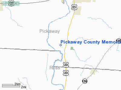
Pickaway County Memorial Airport |
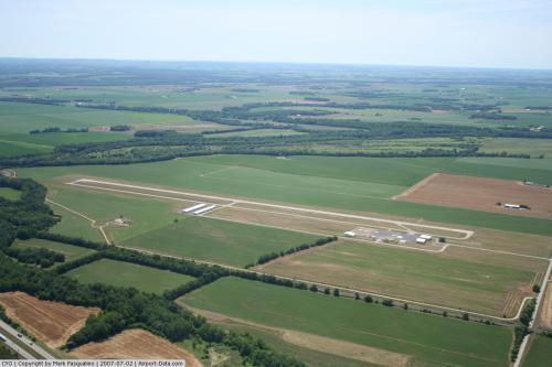 |
(Click on the photo to enlarge) |
Location & QuickFacts
| FAA Information Effective: | 2008-09-25 |
| Airport Identifier: | CYO |
| Airport Status: | Operational |
| Longitude/Latitude: | 082-58-55.7080W/39-30-57.6334N
-82.982141/39.516009 (Estimated) |
| Elevation: | 684 ft / 208.48 m (Estimated) |
| Land: | 61 acres |
| From nearest city: | 5 nautical miles S of Circleville, OH |
| Location: | Pickaway County, OH |
| Magnetic Variation: | 05W (1985) |
Owner & Manager
| Ownership: | Publicly owned |
| Owner: | Pickaway Co Arpt Auth |
| Address: | 28181 Mc Crady Road
Circleville, OH 43113 |
| Phone number: | 740-474-2181 |
| Manager: | Louis Mcfarland |
| Address: | 28181 Mc Crady Road
Circleville, OH 43113 |
| Phone number: | 740-474-5145 |
Airport Operations and Facilities
| Airport Use: | Open to public |
| Wind indicator: | Yes |
| Segmented Circle: | No |
| Control Tower: | No |
| Lighting Schedule: | DUSK-DAWN
ACTVT MIRL RY 01/19, PAPI & REIL RY 19 - CTAF. |
| Beacon Color: | Clear-Green (lighted land airport) |
| Landing fee charge: | No |
| Sectional chart: | Cincinnati |
| Region: | AGL - Great Lakes |
| Boundary ARTCC: | ZID - Indianapolis |
| Tie-in FSS: | DAY - Dayton |
| FSS on Airport: | No |
| FSS Toll Free: | 1-800-WX-BRIEF |
| NOTAMs Facility: | DAY (NOTAM-d service avaliable) |
| Federal Agreements: | NGY |
Airport Communications
| CTAF: | 122.700 |
| Unicom: | 122.700 |
Airport Services
| Fuel available: | 100LLA |
| Airframe Repair: | MINOR |
| Bottled Oxygen: | NONE |
| Bulk Oxygen: | NONE |
Runway Information
Runway 01/19
| Dimension: | 4351 x 75 ft / 1326.2 x 22.9 m |
| Surface: | ASPH, Good Condition |
| Weight Limit: | Single wheel: 30000 lbs.
Dual wheel: 40000 lbs. |
| Edge Lights: | Medium |
| |
Runway 01 |
Runway 19 |
| Longitude: | 082-58-57.2076W | 082-58-54.2081W |
| Latitude: | 39-30-36.1672N | 39-31-19.0996N |
| Elevation: | 664.00 ft | 684.00 ft |
| Alignment: | 3 | 127 |
| Traffic Pattern: | Left | Left |
| Markings: | Non-precision instrument, Fair Condition | Non-precision instrument, Fair Condition |
| Crossing Height: | 0.00 ft | 27.00 ft |
| VASI: | | 4-light PAPI on right side |
| Visual Glide Angle: | 0.00° | 3.00° |
| Runway End Identifier: | | Yes |
| Centerline Lights: | No | No |
| Touchdown Lights: | No | No |
| Obstruction: | 79 ft trees, 1625.0 ft from runway, 250 ft right of centerline, 18:1 slope to clear | 15 ft road, 640.0 ft from runway, 29:1 slope to clear |
|
Radio Navigation Aids
| ID |
Type |
Name |
Ch |
Freq |
Var |
Dist |
| CYO | NDB | Circleville | | 366.00 | 05W | 0.4 nm |
| RZT | NDB | Ross County | | 236.00 | 05W | 5.2 nm |
| CSS | NDB | Court House | | 414.00 | 05W | 19.6 nm |
| BU | NDB | Boutn | | 230.00 | 05W | 20.9 nm |
| EOP | NDB | Waverly | | 385.00 | 06W | 21.1 nm |
| CHC | NDB | Grens | | 272.00 | 04W | 29.8 nm |
| CM | NDB | Sumie | | 391.00 | 05W | 30.2 nm |
| HOC | NDB | Hillsboro | | 278.00 | 05W | 32.8 nm |
| UYF | NDB | London | | 263.00 | 06W | 33.7 nm |
| DKG | NDB | Don Scott | | 348.00 | 05W | 34.2 nm |
| OS | NDB | Fuler | | 515.00 | 05W | 35.0 nm |
| IL | NDB | Airbo | | 407.00 | 04W | 35.0 nm |
| HEH | NDB | Newark | | 524.00 | 06W | 38.9 nm |
| PZO | NDB | Peebles | | 329.00 | 02W | 39.2 nm |
| HW | NDB | Cubla | | 299.00 | 04W | 42.6 nm |
| CCJ | NDB | Clark County | | 341.00 | 04W | 42.7 nm |
| UGS | NDB | University | | 250.00 | 06W | 42.7 nm |
| PMH | NDB | Portsmouth | | 373.00 | 04W | 44.6 nm |
| XEN | NDB | Xenia | | 395.00 | 03W | 45.5 nm |
| MRT | NDB | Marysville | | 403.00 | 05W | 46.0 nm |
| DLZ | NDB | Delaware | | 215.00 | 06W | 46.1 nm |
| AMT | NDB | West Union | | 359.00 | 04W | 48.0 nm |
| LCK | TACAN | Rickenbacker | 069X | | 05W | 17.7 nm |
| XSF | TACAN | Springfield | 065X | | 04W | 44.2 nm |
| XUB | VOR | Yellow Bud | | 112.50 | 05W | 0.7 nm |
| MXQ | VOR/DME | Midwest | 076X | 112.90 | 04W | 38.4 nm |
| SGH | VOR/DME | Springfield | 079X | 113.20 | 04W | 44.3 nm |
| APE | VORTAC | Appleton | 114X | 116.70 | 06W | 42.3 nm |
| CMH | VOT | Port Columbus | | 111.00 | | 29.1 nm |
Images and information placed above are from
http://www.airport-data.com/airport/CYO/
We thank them for the data!
| General Info
|
| Country |
United States
|
| State |
OHIO
|
| FAA ID |
CYO
|
| Latitude |
39-30-57.622N
|
| Longitude |
082-58-55.753W
|
| Elevation |
685 feet
|
| Near City |
CIRCLEVILLE
|
We don't guarantee the information is fresh and accurate. The data may
be wrong or outdated.
For more up-to-date information please refer to other sources.
|
|


