 |
|
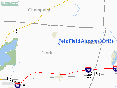
Location & QuickFacts
| FAA Information Effective: | 2008-09-25 |
| Airport Identifier: | 3OH3 |
| Airport Status: | Operational |
| Longitude/Latitude: | 083-36-47.7270W/39-59-02.2160N
-83.613258/39.983949 (Estimated) |
| Elevation: | 990 ft / 301.75 m (Estimated) |
| Land: | 0 acres |
| From nearest city: | 4 nautical miles N of South Vienna, OH |
| Location: | Clark County, OH |
| Magnetic Variation: | 04W (1985) |
Owner & Manager
| Ownership: | Privately owned |
| Owner: | Steven Pelz |
| Address: | Po Box 110
Catawba, OH 43010 |
| Phone number: | 828-1729 |
| Manager: | Steven Pelz |
| Address: | Po Box 110
Catawba, OH 43010 |
| Phone number: | 828-1729 |
Airport Operations and Facilities
| Airport Use: | Private
PERSONAL USE. |
| Segmented Circle: | No |
| Control Tower: | No |
| Sectional chart: | Cincinnati |
| Region: | AGL - Great Lakes |
| Boundary ARTCC: | ZID - Indianapolis |
| Tie-in FSS: | DAY - Dayton |
| FSS on Airport: | No |
| FSS Toll Free: | 1-800-WX-BRIEF |
Runway Information
Runway 07/25
| Dimension: | 2200 x 40 ft / 670.6 x 12.2 m |
| Surface: | TURF, |
| |
Runway 07 |
Runway 25 |
| Traffic Pattern: | Left | Left |
| Obstruction: | | 40 ft wires, 600.0 ft from runway |
|
Radio Navigation Aids
| ID |
Type |
Name |
Ch |
Freq |
Var |
Dist |
| UYF | NDB | London | | 263.00 | 06W | 7.4 nm |
| CCJ | NDB | Clark County | | 341.00 | 04W | 10.1 nm |
| MRT | NDB | Marysville | | 403.00 | 05W | 19.0 nm |
| OS | NDB | Fuler | | 515.00 | 05W | 19.9 nm |
| BU | NDB | Boutn | | 230.00 | 05W | 21.3 nm |
| XEN | NDB | Xenia | | 395.00 | 03W | 21.8 nm |
| EDJ | NDB | Bellefontaine | | 242.00 | 05W | 25.0 nm |
| CSS | NDB | Court House | | 414.00 | 05W | 25.2 nm |
| DKG | NDB | Don Scott | | 348.00 | 05W | 25.3 nm |
| CHC | NDB | Grens | | 272.00 | 04W | 27.0 nm |
| RUV | NDB | Rushsylvania | | 326.00 | 05W | 28.7 nm |
| DLZ | NDB | Delaware | | 215.00 | 06W | 29.3 nm |
| IL | NDB | Airbo | | 407.00 | 04W | 30.1 nm |
| CM | NDB | Sumie | | 391.00 | 05W | 39.6 nm |
| HW | NDB | Cubla | | 299.00 | 04W | 39.8 nm |
| CYO | NDB | Circleville | | 366.00 | 05W | 40.3 nm |
| RZT | NDB | Ross County | | 236.00 | 05W | 42.5 nm |
| VES | NDB | Versailles | | 356.00 | 04W | 43.9 nm |
| MNN | NDB | Marion | | 201.00 | 05W | 45.5 nm |
| LYL | NDB | Lima | | 362.00 | 04W | 47.2 nm |
| HOC | NDB | Hillsboro | | 278.00 | 05W | 48.2 nm |
| HKF | NDB | Hook Field | | 239.00 | 04W | 48.3 nm |
| XSF | TACAN | Springfield | 065X | | 04W | 13.7 nm |
| FFO | TACAN | Patterson | 099X | | 04W | 22.7 nm |
| LCK | TACAN | Rickenbacker | 069X | | 05W | 33.3 nm |
| XUB | VOR | Yellow Bud | | 112.50 | 05W | 40.2 nm |
| BUD | VOR | Buckeye | | 109.80 | 05W | 45.6 nm |
| AOH | VOR | Allen County | | 108.40 | 04W | 46.4 nm |
| SGH | VOR/DME | Springfield | 079X | 113.20 | 04W | 13.9 nm |
| MXQ | VOR/DME | Midwest | 076X | 112.90 | 04W | 34.4 nm |
| DQN | VOR/DME | Dayton | 092X | 114.50 | 01W | 36.1 nm |
| ROD | VORTAC | Rosewood | 122X | 117.50 | 05W | 26.9 nm |
| APE | VORTAC | Appleton | 114X | 116.70 | 06W | 48.2 nm |
| DAY | VOT | Dayton J M Cox-day | | 111.00 | | 28.4 nm |
| CMH | VOT | Port Columbus | | 111.00 | | 33.5 nm |
Remarks
- OWNER DESIRES ARPT NOT TO BE CHARTED.
- PRVDD OBSTN IN RY APCH SLOPE BE LOWERED/REMOVED OR THR DSPLCD & CLEARLY MKD TO PROVIDE 20:1 APCH SFC CLNC OVER OBSTN.
Images and information placed above are from
http://www.airport-data.com/airport/3OH3/
We thank them for the data!
| General Info
|
| Country |
United States
|
| State |
OHIO
|
| FAA ID |
3OH3
|
| Latitude |
39-59-02.216N
|
| Longitude |
083-36-47.727W
|
| Elevation |
990 feet
|
| Near City |
SOUTH VIENNA
|
We don't guarantee the information is fresh and accurate. The data may
be wrong or outdated.
For more up-to-date information please refer to other sources.
|
|


