 |
|
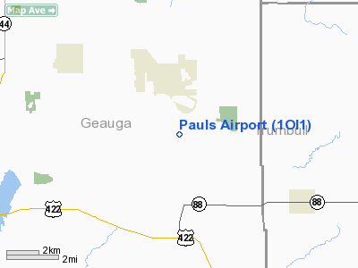
Location & QuickFacts
| FAA Information Effective: | 2008-09-25 |
| Airport Identifier: | 1OI1 |
| Airport Status: | Operational |
| Longitude/Latitude: | 081-03-50.3460W/41-25-42.1960N
-81.063985/41.428388 (Estimated) |
| Elevation: | 1191 ft / 363.02 m (Estimated) |
| Land: | 0 acres |
| From nearest city: | 3 nautical miles N of Middlefield, OH |
| Location: | Geauga County, OH |
| Magnetic Variation: | 07W (1985) |
Owner & Manager
| Ownership: | Privately owned |
| Owner: | Paul G. Pechura |
| Address: | 16156 Shedd Rd, Rt 3
Middlefield, OH 44062 |
| Phone number: | 216-632-5404 |
| Address: |
|
Airport Operations and Facilities
| Airport Use: | Private |
| Wind indicator: | Yes |
| Segmented Circle: | No |
| Control Tower: | No |
| Landing fee charge: | No |
| Sectional chart: | Detroit |
| Region: | AGL - Great Lakes |
| Boundary ARTCC: | ZOB - Cleveland |
| Tie-in FSS: | CLE - Cleveland |
| FSS on Airport: | No |
| FSS Toll Free: | 1-800-WX-BRIEF |
Runway Information
Runway 06/24
| Dimension: | 2550 x 150 ft / 777.2 x 45.7 m |
| Surface: | TURF, |
| |
Runway 06 |
Runway 24 |
| Traffic Pattern: | Left | Left |
| Obstruction: | 40 ft pline, 20.0 ft from runway | 40 ft pline, 20.0 ft from runway |
|
Radio Navigation Aids
| ID |
Type |
Name |
Ch |
Freq |
Var |
Dist |
| LQL | NDB | Lakeland | | 263.00 | 08W | 20.8 nm |
| AK | NDB | Akron | | 362.00 | 07W | 26.0 nm |
| BKL | NDB | Burke Lakefront | | 416.00 | 07W | 27.7 nm |
| HBD | NDB | Hubbard | | 408.00 | 08W | 29.2 nm |
| EZE | NDB | Engel | | 226.00 | 07W | 29.9 nm |
| UCP | NDB | Castle | | 272.00 | 09W | 38.1 nm |
| CL | NDB | Harri | | 344.00 | 07W | 41.0 nm |
| CXR | VOR/DME | Chardon | 074X | 112.70 | 05W | 6.9 nm |
| ACO | VOR/DME | Akron | 091X | 114.40 | 04W | 20.2 nm |
| LNN | VOR/DME | Lost Nation | 039X | 110.20 | 08W | 21.2 nm |
| JFN | VOR/DME | Jefferson | 099X | 115.20 | 05W | 24.5 nm |
| BSV | VOR/DME | Briggs | 071X | 112.40 | 04W | 44.6 nm |
| DJB | VOR/DME | Dryer | 083X | 113.60 | 05W | 49.7 nm |
| YNG | VORTAC | Youngstown | 027X | 109.00 | 05W | 18.5 nm |
| ERI | VORTAC | Erie | 031X | 109.40 | 06W | 49.5 nm |
| CAK | VOT | Akron/canton Regional | | 110.60 | | 35.2 nm |
| CLE | VOT | Cleveland | | 110.40 | | 35.4 nm |
Remarks
- AEROBATIC WAIVER MAY BE ACTIVE FROM SFC TO 5000' IN. ONE MILE RADIUS OF ARPT.
- (A56-10) ACFT 45' LEFT & 75' RIGHT.
- DUE TO THE INCOMPATIBILITY OF THE ARPT TFC PAT AIRSPACE AREAS ASSOCIATED WITH PAULS & GEAUGA COUNTY AIRPORTS.
Images and information placed above are from
http://www.airport-data.com/airport/1OI1/
We thank them for the data!
| General Info
|
| Country |
United States
|
| State |
OHIO
|
| FAA ID |
1OI1
|
| Latitude |
41-25-42.196N
|
| Longitude |
081-03-50.346W
|
| Elevation |
1191 feet
|
| Near City |
MIDDLEFIELD
|
We don't guarantee the information is fresh and accurate. The data may
be wrong or outdated.
For more up-to-date information please refer to other sources.
|
|


