 |
|
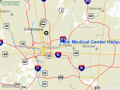
Park Medical Center Heliport |
Location & QuickFacts
| FAA Information Effective: | 2008-09-25 |
| Airport Identifier: | 2OI6 |
| Airport Status: | Operational |
| Longitude/Latitude: | 082-57-44.6530W/39-58-13.2310N
-82.962404/39.970342 (Estimated) |
| Elevation: | 1020 ft / 310.90 m (Estimated) |
| Land: | 0 acres |
| From nearest city: | 0 nautical miles N of Columbus, OH |
| Location: | Franklin County, OH |
| Magnetic Variation: | 05W (1985) |
Owner & Manager
| Ownership: | Privately owned |
| Owner: | Park Medical Center |
| Address: | 1492 E. Broad Street
Columbus, OH 43205 |
| Phone number: | 614-251-3291 |
| Manager: | J. Richard Chiles |
| Address: | 1492 E. Broad Street
Columbus, OH 43205 |
| Phone number: | 614-251-3291 |
Airport Operations and Facilities
| Airport Use: | Private
MEDICAL USE. |
| Wind indicator: | No |
| Segmented Circle: | Yes |
| Control Tower: | No |
| Landing fee charge: | No |
| Sectional chart: | Cincinnati |
| Region: | AGL - Great Lakes |
| Boundary ARTCC: | ZID - Indianapolis |
| Tie-in FSS: | DAY - Dayton |
| FSS on Airport: | No |
| FSS Toll Free: | 1-800-WX-BRIEF |
Runway Information
Helipad H1
| Dimension: | 85 x 85 ft / 25.9 x 25.9 m
CIRCULAR LANDING PAD. |
| Surface: | CONC, |
| |
Runway H1 |
Runway |
| Traffic Pattern: | Left | Left |
|
Radio Navigation Aids
| ID |
Type |
Name |
Ch |
Freq |
Var |
Dist |
| CHC | NDB | Grens | | 272.00 | 04W | 3.9 nm |
| DKG | NDB | Don Scott | | 348.00 | 05W | 8.5 nm |
| CM | NDB | Sumie | | 391.00 | 05W | 9.6 nm |
| OS | NDB | Fuler | | 515.00 | 05W | 12.5 nm |
| BU | NDB | Boutn | | 230.00 | 05W | 14.4 nm |
| DLZ | NDB | Delaware | | 215.00 | 06W | 19.5 nm |
| HEH | NDB | Newark | | 524.00 | 06W | 23.2 nm |
| UYF | NDB | London | | 263.00 | 06W | 23.3 nm |
| MRT | NDB | Marysville | | 403.00 | 05W | 23.5 nm |
| CYO | NDB | Circleville | | 366.00 | 05W | 26.9 nm |
| CSS | NDB | Court House | | 414.00 | 05W | 29.8 nm |
| RZT | NDB | Ross County | | 236.00 | 05W | 32.1 nm |
| CCJ | NDB | Clark County | | 341.00 | 04W | 38.1 nm |
| MNN | NDB | Marion | | 201.00 | 05W | 39.2 nm |
| RUV | NDB | Rushsylvania | | 326.00 | 05W | 43.7 nm |
| IL | NDB | Airbo | | 407.00 | 04W | 45.9 nm |
| EDJ | NDB | Bellefontaine | | 242.00 | 05W | 45.9 nm |
| XEN | NDB | Xenia | | 395.00 | 03W | 47.2 nm |
| HRA | NDB | Zanesville | | 204.00 | 06W | 48.2 nm |
| EOP | NDB | Waverly | | 385.00 | 06W | 48.3 nm |
| LCK | TACAN | Rickenbacker | 069X | | 05W | 9.9 nm |
| XSF | TACAN | Springfield | 065X | | 04W | 41.3 nm |
| XUB | VOR | Yellow Bud | | 112.50 | 05W | 26.7 nm |
| BUD | VOR | Buckeye | | 109.80 | 05W | 39.1 nm |
| SGH | VOR/DME | Springfield | 079X | 113.20 | 04W | 41.5 nm |
| TVT | VOR/DME | Tiverton | 112X | 116.50 | 03W | 48.3 nm |
| ZZV | VOR/DME | Zanesville | 051X | 111.40 | 06W | 49.3 nm |
| APE | VORTAC | Appleton | 114X | 116.70 | 06W | 20.4 nm |
| CMH | VOT | Port Columbus | | 111.00 | | 3.8 nm |
Remarks
- (E111-2) AS THE CENTER OF A COMPASS ROSE; APCH/DEPARTURE ROUTE OPERATIONS TO/FROM THE HELIPAD OTHER THAN THOSE IN THE IMMEDIATE AREA ARE FLOWN AS.
- (E111-3) DIRECTED THE PORT COLUMBUS ATCT; TAKEOFF/LANDING AREA IS APPROPRIATELY MARKED; NON-OBSTRUCTING WIND INDICATOR IS MAINTAINED ADJACENT TO PAD.
- PRVDD COMMS ARE ESTABLISHED WITH PORT COLUMBUS ATCT PRIOR TO DEPARTURE AND PRIOR TO ENTRY INTO THE PORT COLOMBUS CTLZ. APCH/DEPARTURE ROUTE HELICOPTER OPERATIONS ARE CONDUCTED IN AN AREA FROM 001 DEGS CLOCKWISE TO 360 DEGS USING THE TOUCHDOWN PAD.
Images and information placed above are from
http://www.airport-data.com/airport/2OI6/
We thank them for the data!
| General Info
|
| Country |
United States
|
| State |
OHIO
|
| FAA ID |
2OI6
|
| Latitude |
39-58-13.231N
|
| Longitude |
082-57-44.653W
|
| Elevation |
1020 feet
|
| Near City |
COLUMBUS
|
We don't guarantee the information is fresh and accurate. The data may
be wrong or outdated.
For more up-to-date information please refer to other sources.
|
|


