 |
|
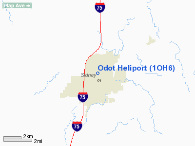
Location & QuickFacts
| FAA Information Effective: | 2008-09-25 |
| Airport Identifier: | 1OH6 |
| Airport Status: | Operational |
| Longitude/Latitude: | 084-09-48.2960W/40-17-51.1780N
-84.163416/40.297549 (Estimated) |
| Elevation: | 1026 ft / 312.72 m (Estimated) |
| Land: | 0 acres |
| From nearest city: | 1 nautical miles NW of Sidney, OH |
| Location: | Shelby County, OH |
| Magnetic Variation: | 04W (1985) |
Owner & Manager
| Ownership: | Publicly owned |
| Owner: | District 7 Ohio Dot |
| Address: | 1001 St Marys Ave
Sidney, OH 45365 |
| Phone number: | 513-492-1141 |
| Manager: | Lonnie C Falknor |
| Address: | 6886 Sr 47
Versailles, OH 45380 |
| Phone number: | 513-492-1141 |
Airport Operations and Facilities
| Airport Use: | Private |
| Wind indicator: | Yes |
| Segmented Circle: | No |
| Control Tower: | No |
| Landing fee charge: | No |
| Sectional chart: | Detroit |
| Region: | AGL - Great Lakes |
| Boundary ARTCC: | ZID - Indianapolis |
| Tie-in FSS: | DAY - Dayton |
| FSS on Airport: | No |
| FSS Toll Free: | 1-800-WX-BRIEF |
Runway Information
Helipad H1
| Dimension: | 35 x 35 ft / 10.7 x 10.7 m |
| Surface: | CONC, |
| |
Runway H1 |
Runway |
| Traffic Pattern: | Left | Left |
|
Radio Navigation Aids
| ID |
Type |
Name |
Ch |
Freq |
Var |
Dist |
| EDJ | NDB | Bellefontaine | | 242.00 | 05W | 16.6 nm |
| VES | NDB | Versailles | | 356.00 | 04W | 17.4 nm |
| CQA | NDB | Lakefield | | 205.00 | 04W | 21.4 nm |
| RUV | NDB | Rushsylvania | | 326.00 | 05W | 24.7 nm |
| LYL | NDB | Lima | | 362.00 | 04W | 25.3 nm |
| CCJ | NDB | Clark County | | 341.00 | 04W | 31.0 nm |
| XEN | NDB | Xenia | | 395.00 | 03W | 36.6 nm |
| MRT | NDB | Marysville | | 403.00 | 05W | 37.6 nm |
| PLD | NDB | Portland | | 257.00 | 03W | 38.7 nm |
| UYF | NDB | London | | 263.00 | 06W | 38.8 nm |
| VFU | NDB | Stanley | | 411.00 | 05W | 39.7 nm |
| PDR | NDB | Ottawa | | 233.00 | 05W | 44.9 nm |
| OS | NDB | Fuler | | 515.00 | 05W | 46.3 nm |
| DLZ | NDB | Delaware | | 215.00 | 06W | 48.6 nm |
| BNR | NDB | Benton Ridge | | 334.00 | 05W | 49.0 nm |
| HKF | NDB | Hook Field | | 239.00 | 04W | 49.8 nm |
| FFO | TACAN | Patterson | 099X | | 04W | 29.2 nm |
| XSF | TACAN | Springfield | 065X | | 04W | 31.4 nm |
| AOH | VOR | Allen County | | 108.40 | 04W | 26.2 nm |
| MAH | VOR | Marathon | | 114.90 | 05W | 48.8 nm |
| DQN | VOR/DME | Dayton | 092X | 114.50 | 01W | 20.0 nm |
| SGH | VOR/DME | Springfield | 079X | 113.20 | 04W | 31.3 nm |
| ROD | VORTAC | Rosewood | 122X | 117.50 | 05W | 5.5 nm |
| FDY | VORTAC | Findlay | 019X | 108.20 | 02W | 43.7 nm |
| RID | VORTAC | Richmond | 043X | 110.60 | 03W | 45.1 nm |
| DAY | VOT | Dayton J M Cox-day | | 111.00 | | 23.9 nm |
Remarks
- INGRESS/EGRESS RTES CONDUCTED WI AREA 225-295 DEG(CW); OPERNS ONLY DUR DALGT OR TIL APPROPRIATE NGT LGTG INSTALLED.
Images and information placed above are from
http://www.airport-data.com/airport/1OH6/
We thank them for the data!
| General Info
|
| Country |
United States
|
| State |
OHIO
|
| FAA ID |
1OH6
|
| Latitude |
40-17-51.178N
|
| Longitude |
084-09-48.296W
|
| Elevation |
1026 feet
|
| Near City |
SIDNEY
|
We don't guarantee the information is fresh and accurate. The data may
be wrong or outdated.
For more up-to-date information please refer to other sources.
|
|


