 |
|
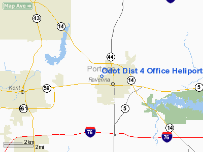
Odot Dist 4 Office Heliport |
Location & QuickFacts
| FAA Information Effective: | 2008-09-25 |
| Airport Identifier: | 60OH |
| Airport Status: | Operational |
| Longitude/Latitude: | 081-15-30.3720W/41-09-59.2030N
-81.258437/41.166445 (Estimated) |
| Elevation: | 1087 ft / 331.32 m (Estimated) |
| Land: | 0 acres |
| From nearest city: | 1 nautical miles NW of Ravenna, OH |
| Location: | Portage County, OH |
| Magnetic Variation: | 07W (1985) |
Owner & Manager
| Ownership: | Publicly owned |
| Owner: | Ohio Dept Of Transportation |
| Address: | 705 Oakwood St
Ravenna, OH 44266 |
| Manager: | Herbert Riggs |
| Address: | 705 Oakwood St
Ravenna, OH 44266 |
| Phone number: | 216-297-0801 |
Airport Operations and Facilities
| Airport Use: | Private |
| Wind indicator: | Yes |
| Segmented Circle: | No |
| Control Tower: | No |
| Landing fee charge: | No |
| Sectional chart: | Detroit |
| Region: | AGL - Great Lakes |
| Boundary ARTCC: | ZOB - Cleveland |
| Tie-in FSS: | CLE - Cleveland |
| FSS on Airport: | No |
| FSS Toll Free: | 1-800-WX-BRIEF |
Runway Information
Helipad H1
| Dimension: | 125 x 250 ft / 38.1 x 76.2 m |
| Surface: | ASPH, |
| |
Runway H1 |
Runway |
| Traffic Pattern: | Left | Left |
|
Radio Navigation Aids
| ID |
Type |
Name |
Ch |
Freq |
Var |
Dist |
| AK | NDB | Akron | | 362.00 | 07W | 8.2 nm |
| BKL | NDB | Burke Lakefront | | 416.00 | 07W | 28.4 nm |
| EZE | NDB | Engel | | 226.00 | 07W | 28.5 nm |
| LQL | NDB | Lakeland | | 263.00 | 08W | 31.5 nm |
| HBD | NDB | Hubbard | | 408.00 | 08W | 32.9 nm |
| CL | NDB | Harri | | 344.00 | 07W | 33.5 nm |
| TSO | NDB | Tolson | | 395.00 | 07W | 37.2 nm |
| UCP | NDB | Castle | | 272.00 | 09W | 39.1 nm |
| AAU | NDB | Ashland | | 329.00 | 07W | 46.7 nm |
| MLR | NDB | Millersburg/dcmsnd | | 382.00 | 06W | 46.8 nm |
| ACO | VOR/DME | Akron | 091X | 114.40 | 04W | 4.4 nm |
| CXR | VOR/DME | Chardon | 074X | 112.70 | 05W | 21.5 nm |
| BSV | VOR/DME | Briggs | 071X | 112.40 | 04W | 26.8 nm |
| LNN | VOR/DME | Lost Nation | 039X | 110.20 | 08W | 31.7 nm |
| DJB | VOR/DME | Dryer | 083X | 113.60 | 05W | 42.4 nm |
| JFN | VOR/DME | Jefferson | 099X | 115.20 | 05W | 42.4 nm |
| YNG | VORTAC | Youngstown | 027X | 109.00 | 05W | 28.2 nm |
| CAK | VOT | Akron/canton Regional | | 110.60 | | 17.2 nm |
| CLE | VOT | Cleveland | | 110.40 | | 30.4 nm |
Remarks
- OWNER REQ NOT TO BE CHARTED.
- PROVIDED INGRESS/EGRESS OPNS CONDUCTED IN AREA CLKWS 160 DEG TO 145 DEG FM PAD.
Images and information placed above are from
http://www.airport-data.com/airport/60OH/
We thank them for the data!
| General Info
|
| Country |
United States
|
| State |
OHIO
|
| FAA ID |
60OH
|
| Latitude |
41-09-59.203N
|
| Longitude |
081-15-30.372W
|
| Elevation |
1087 feet
|
| Near City |
RAVENNA
|
We don't guarantee the information is fresh and accurate. The data may
be wrong or outdated.
For more up-to-date information please refer to other sources.
|
|


