 |
|
Coordinates: 40°01′29″N 082°27′43″W / 40.02472°N 82.46194°W / 40.02472; -82.46194
| Newark-Heath Airport |
| IATA: none – ICAO: KVTA – FAA LID: VTA |
| Summary |
| Airport type |
Public |
| Owner |
Licking County Regional Airport Authority |
| Serves |
Newark, Ohio |
| Location |
Heath, Ohio |
| Elevation AMSL |
884 ft / 269 m |
| Runways |
| Direction |
Length |
Surface |
| ft |
m |
| 9/27 |
4,649 |
1,417 |
Asphalt |
| Statistics (2007) |
| Aircraft operations |
12,457 |
| Source: Federal Aviation Administration |
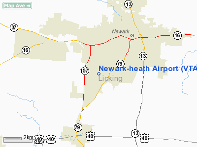
Newark-Heath Airport (ICAO: KVTA, FAA LID: VTA) is a public airport located in Heath, Ohio. It is three miles (5 km) southwest of the central business district of Newark, a city in Licking County, Ohio, United States. It is owned by the Licking County Regional Airport Authority.
Although most U.S. airports use the same three-letter location identifier for the FAA and IATA, Newark-Heath Airport is assigned VTA by the FAA but has no designation from the IATA.
Facilities and aircraft
Newark-Heath Airport covers an area of 140 acres (57 ha) which contains one asphalt paved runway (9/27) measuring 4,649 x 75 ft (1,417 x 23 m) For the 12-month period ending March 20, 2007, the airport had 12,457 aircraft operations, an average of 34 per day: 99% general aviation, <1% military and <1% air taxi.
The above content comes from Wikipedia and is published under free licenses – click here to read more.
Location & QuickFacts
| FAA Information Effective: | 2008-09-25 |
| Airport Identifier: | VTA |
| Airport Status: | Operational |
| Longitude/Latitude: | 082-27-42.5308W/40-01-28.7733N
-82.461814/40.024659 (Estimated) |
| Elevation: | 884 ft / 269.44 m (Surveyed) |
| Land: | 140 acres |
| From nearest city: | 3 nautical miles SW of Newark, OH |
| Location: | Licking County, OH |
| Magnetic Variation: | 06W (1990) |
Owner & Manager
| Ownership: | Publicly owned |
| Owner: | Licking Co Reg Arpt Auth |
| Address: | 530 Heath Rd
Heath, OH 43056 |
| Phone number: | 740-522-6968 |
| Manager: | Harold Ware |
| Address: | 530 Heath Rd
Heath, OH 43056 |
| Phone number: | 740-522-6968 |
Airport Operations and Facilities
| Airport Use: | Open to public |
| Wind indicator: | Yes |
| Segmented Circle: | No |
| Control Tower: | No |
| Lighting Schedule: | DUSK-DAWN
MIRL RY 09/27 & REIL RYS 09 & 27 OPER LOW INTS CONT TO INCREASE INTS - 123.3. |
| Beacon Color: | Clear-Green (lighted land airport) |
| Landing fee charge: | No |
| Sectional chart: | Detroit |
| Region: | AGL - Great Lakes |
| Traffic Pattern Alt: | 1016 ft |
| Boundary ARTCC: | ZID - Indianapolis |
| Tie-in FSS: | DAY - Dayton |
| FSS on Airport: | No |
| FSS Toll Free: | 1-800-WX-BRIEF |
| NOTAMs Facility: | VTA (NOTAM-d service avaliable) |
| Federal Agreements: | NGY |
Airport Communications
| CTAF: | 122.700 |
| Unicom: | 122.700 |
Airport Services
| Fuel available: | 100LLA1+
AVBL SUN-SAT 0730 - DARK. |
| Airframe Repair: | MAJOR |
| Power Plant Repair: | MAJOR |
| Bottled Oxygen: | NONE |
| Bulk Oxygen: | HIGH/LOW |
Runway Information
Runway 09/27
| Dimension: | 4649 x 75 ft / 1417.0 x 22.9 m |
| Surface: | ASPH, Fair Condition |
| Weight Limit: | Single wheel: 30000 lbs. |
| Edge Lights: | Medium |
| |
Runway 09 |
Runway 27 |
| Longitude: | 082-28-12.3600W | 082-27-12.6975W |
| Latitude: | 40-01-27.5500N | 40-01-29.9941N |
| Elevation: | 882.00 ft | 870.00 ft |
| Alignment: | 87 | 127 |
| ILS Type: | LOCALIZER
| |
| Traffic Pattern: | Left | Left |
| Markings: | Non-precision instrument, Good Condition | Non-precision instrument, Good Condition |
| Crossing Height: | 27.00 ft | 20.00 ft |
| Displaced threshold: | 455.00 ft | 0.00 ft |
| VASI: | 4-light PAPI on left side | 4-light PAPI on right side |
| Visual Glide Angle: | 3.25° | 3.25° |
| Runway End Identifier: | Yes
RY 09 & 27 REILS OTS INDEFLY. | Yes |
| Centerline Lights: | No | No |
| Touchdown Lights: | No | No |
| Obstruction: | 15 ft road, 201.0 ft from runway, 168 ft right of centerline
RWY 09 APCH RATIO 5:1 OVER +15 FT ROAD 279 FT FM DSPLCD THLD 266 FT R.
RWY 09 +15 FT ROAD 0 FT FM END 200 FT R. | 12 ft fence, 201.0 ft from runway, 237 ft left of centerline
RWY 27 +8 FT RIDGE 0 FT FM RY END 190 FT L; +15 FT ROAD 0 FT FM 227 FT L; +8 FT FENCE 0 FT FM 224 FT L |
|
Radio Navigation Aids
| ID |
Type |
Name |
Ch |
Freq |
Var |
Dist |
| HEH | NDB | Newark | | 524.00 | 06W | 0.1 nm |
| CM | NDB | Sumie | | 391.00 | 05W | 13.7 nm |
| HRA | NDB | Zanesville | | 204.00 | 06W | 26.0 nm |
| CHC | NDB | Grens | | 272.00 | 04W | 26.1 nm |
| DKG | NDB | Don Scott | | 348.00 | 05W | 28.6 nm |
| DLZ | NDB | Delaware | | 215.00 | 06W | 33.1 nm |
| OS | NDB | Fuler | | 515.00 | 05W | 34.0 nm |
| BU | NDB | Boutn | | 230.00 | 05W | 36.4 nm |
| CYO | NDB | Circleville | | 366.00 | 05W | 38.5 nm |
| MLR | NDB | Millersburg/dcmsnd | | 382.00 | 06W | 41.2 nm |
| MRT | NDB | Marysville | | 403.00 | 05W | 42.6 nm |
| RZT | NDB | Ross County | | 236.00 | 05W | 43.9 nm |
| MF | NDB | Manns | | 372.00 | 06W | 44.6 nm |
| MNN | NDB | Marion | | 201.00 | 05W | 45.2 nm |
| UYF | NDB | London | | 263.00 | 06W | 46.6 nm |
| UGS | NDB | University | | 250.00 | 06W | 48.7 nm |
| CSS | NDB | Court House | | 414.00 | 05W | 49.9 nm |
| LCK | TACAN | Rickenbacker | 069X | | 05W | 25.2 nm |
| XUB | VOR | Yellow Bud | | 112.50 | 05W | 38.3 nm |
| BUD | VOR | Buckeye | | 109.80 | 05W | 45.0 nm |
| ZZV | VOR/DME | Zanesville | 051X | 111.40 | 06W | 26.7 nm |
| TVT | VOR/DME | Tiverton | 112X | 116.50 | 03W | 30.2 nm |
| CTW | VOR/DME | Newcomerstown | 055X | 111.80 | 07W | 46.9 nm |
| APE | VORTAC | Appleton | 114X | 116.70 | 06W | 9.6 nm |
| CMH | VOT | Port Columbus | | 111.00 | | 19.6 nm |
Remarks
- DEER OCCASIONALLY ON OR NEAR RY.
Images and information placed above are from
http://www.airport-data.com/airport/VTA/
We thank them for the data!
| General Info
|
| Country |
United States
|
| State |
OHIO
|
| FAA ID |
VTA
|
| Latitude |
40-01-28.773N
|
| Longitude |
082-27-42.531W
|
| Elevation |
884 feet
|
| Near City |
NEWARK
|
We don't guarantee the information is fresh and accurate. The data may
be wrong or outdated.
For more up-to-date information please refer to other sources.
|
|


