 |
|
Coordinates: 39°40′57″N 084°14′35″W / 39.6825°N 84.24306°W / 39.6825; -84.24306
| Moraine Airpark |
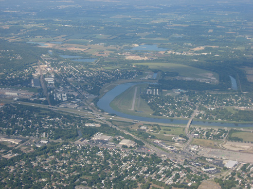 |
| Aerial view of Moraine Airpark from the east |
| IATA: none – ICAO: none – FAA LID: I73 |
| Summary |
| Airport type |
Public |
| Owner |
Moraine Airpark, Inc. & Montgomery County |
| Serves |
Dayton, Ohio |
| Location |
Moraine, Ohio |
| Elevation AMSL |
720 ft / 219 m |
| Website |
www.MoraineAirpark.com |
| Runways |
| Direction |
Length |
Surface |
| ft |
m |
| 8/26 |
3,500 |
1,067 |
Asphalt |
| Statistics (2007) |
| Aircraft operations |
87,263 |
| Based aircraft |
121 |
| Sources: FAA, airport website |
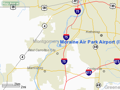
Moraine Airpark (FAA LID: I73) is a public-use airport situated 4 miles (6.4 km) southwest of the city of Dayton in Montgomery County, Ohio, United States. It is located in the city of Moraine.
Facilities and aircraft
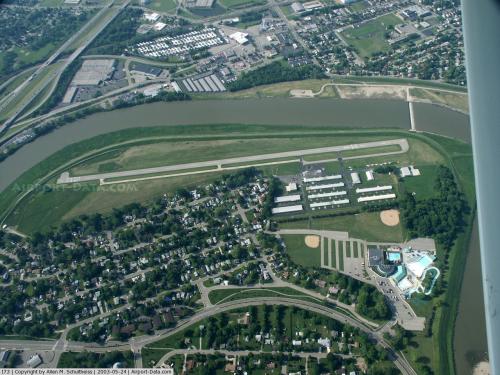
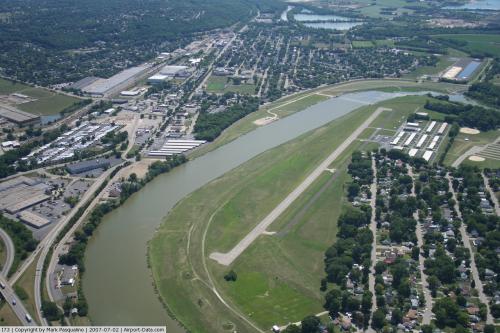
Moraine Airpark covers an area of 155 acres (63 ha) which contains one asphalt paved runway (8/26) measuring 3,500 x 65 ft (1,067 x 20 m); though some use the grassy area next to the runway.
For the 12-month period ending May 9, 2007, the airport had 87,263 aircraft operations, an average of 239 per day: 94% general aviation, 6% air taxi and <1% military. There are 121 aircraft based at this airport: 95% single-engine, 4% multi-engine and 1% glider.
The above content comes from Wikipedia and is published under free licenses – click here to read more.
 |
(Click on the photo to enlarge) |
 |
(Click on the photo to enlarge) |
Location & QuickFacts
| FAA Information Effective: | 2008-09-25 |
| Airport Identifier: | I73 |
| Airport Status: | Operational |
| Longitude/Latitude: | 084-14-34.7870W/39-40-57.2120N
-84.242996/39.682559 (Estimated) |
| Elevation: | 720 ft / 219.46 m (Surveyed) |
| Land: | 155 acres |
| From nearest city: | 4 nautical miles SW of Dayton, OH |
| Location: | Montgomery County, OH |
| Magnetic Variation: | 04W (1985) |
Owner & Manager
| Ownership: | Privately owned
JOINT OWNERSHIP WITH MONTGOMERY CO. |
| Owner: | Moraine Airpark, Inc. |
| Address: | 3800 Clearview Rd
Dayton, OH 45439 |
| Phone number: | 937-866-2489 |
| Manager: | George Bockerstette |
| Address: | 3800 Clearview Rd
Dayton, OH 45439 |
| Phone number: | 937-866-2489 |
Airport Operations and Facilities
| Airport Use: | Open to public |
| Wind indicator: | Yes |
| Segmented Circle: | No |
| Control Tower: | No |
| Lighting Schedule: | DUSK-DAWN |
| Beacon Color: | Clear-Green (lighted land airport) |
| Landing fee charge: | No |
| Sectional chart: | Cincinnati |
| Region: | AGL - Great Lakes |
| Boundary ARTCC: | ZID - Indianapolis |
| Tie-in FSS: | DAY - Dayton |
| FSS on Airport: | No |
| FSS Toll Free: | 1-800-WX-BRIEF |
| NOTAMs Facility: | DAY (NOTAM-d service avaliable) |
Airport Communications
| CTAF: | 122.700 |
| Unicom: | 122.700 |
Airport Services
| Fuel available: | 100LL |
| Airframe Repair: | MAJOR |
| Power Plant Repair: | MAJOR |
| Bottled Oxygen: | NONE |
| Bulk Oxygen: | NONE |
Runway Information
Runway 08/26
| Dimension: | 3500 x 65 ft / 1066.8 x 19.8 m |
| Surface: | ASPH, Good Condition |
| Edge Lights: | Medium |
| |
Runway 08 |
Runway 26 |
| Longitude: | 084-14-56.8800W | 084-14-12.6700W |
| Latitude: | 39-40-54.5000N | 39-40-59.9100N |
| Elevation: | 720.00 ft | 720.00 ft |
| Traffic Pattern: | Left | Left |
| Markings: | Basic, Good Condition | Basic, Good Condition |
| Displaced threshold: | 558.00 ft | 136.00 ft |
| Runway End Identifier: | No | No |
| Centerline Lights: | No | No |
| Touchdown Lights: | No | No |
| Obstruction: | 15 ft dike, 201.0 ft from runway, 75 ft left of centerline
APCH RATIO 16:1 TO DSPLCD THLD; +15 FT DIKE 245 FT FM 150 FT R.
+15 FT LGTD DIKE 0 FT FROM RY END 85 FT RIGHT TO 200 FT FROM EOR 75 FT LEFT. | 6 ft dike, 201.0 ft from runway, 60 ft right of centerline
APCH RATIO 12:1 TO DSPLCD THLD; +15 FT DIKE 180 FT FM 140 FT L.
+6 FT LGTD DIKE 0 FT FROM RY END 125 FT LEFT TO 200 FT FROM EOR 120 FT RIGHT. |
|
Radio Navigation Aids
| ID |
Type |
Name |
Ch |
Freq |
Var |
Dist |
| HKF | NDB | Hook Field | | 239.00 | 04W | 14.6 nm |
| XEN | NDB | Xenia | | 395.00 | 03W | 14.6 nm |
| HAO | NDB | Hamilton | | 260.00 | 04W | 24.1 nm |
| CCJ | NDB | Clark County | | 341.00 | 04W | 24.3 nm |
| HW | NDB | Cubla | | 299.00 | 04W | 26.1 nm |
| IL | NDB | Airbo | | 407.00 | 04W | 26.1 nm |
| ISZ | NDB | Cincinnati-blue Ash | | 388.00 | 04W | 26.9 nm |
| OXD | NDB | Oxford | | 282.00 | 04W | 27.0 nm |
| MDE | NDB | Madeira | | 379.00 | 04W | 28.1 nm |
| LUK | NDB | Cincinnati | | 335.00 | 04W | 31.8 nm |
| VES | NDB | Versailles | | 356.00 | 04W | 34.0 nm |
| PWF | NDB | Sportys | | 245.00 | 04W | 36.4 nm |
| UYF | NDB | London | | 263.00 | 06W | 38.9 nm |
| CSS | NDB | Court House | | 414.00 | 05W | 39.7 nm |
| HOC | NDB | Hillsboro | | 278.00 | 05W | 44.2 nm |
| UR | NDB | Burln | | 321.00 | 04W | 45.5 nm |
| EDJ | NDB | Bellefontaine | | 242.00 | 05W | 45.9 nm |
| BU | NDB | Boutn | | 230.00 | 05W | 48.7 nm |
| FFO | TACAN | Patterson | 099X | | 04W | 11.9 nm |
| XSF | TACAN | Springfield | 065X | | 04W | 20.8 nm |
| SGH | VOR/DME | Springfield | 079X | 113.20 | 04W | 20.6 nm |
| DQN | VOR/DME | Dayton | 092X | 114.50 | 01W | 21.3 nm |
| MXQ | VOR/DME | Midwest | 076X | 112.90 | 04W | 25.5 nm |
| RID | VORTAC | Richmond | 043X | 110.60 | 03W | 27.9 nm |
| ROD | VORTAC | Rosewood | 122X | 117.50 | 05W | 37.5 nm |
| CVG | VORTAC | Cincinnati | 120X | 117.30 | 04W | 45.4 nm |
| DAY | VOT | Dayton J M Cox-day | | 111.00 | | 13.2 nm |
| LUK | VOT | Cincinnati Muni/lunken | | 108.40 | | 34.8 nm |
Remarks
- 15 FT LEVEE S OF & PARALLEL TO RWY. TREES N OF RWY.
- PAEW ADJ TWYS.
- VFR OPNS ONLY
Images and information placed above are from
http://www.airport-data.com/airport/I73/
We thank them for the data!
| General Info
|
| Country |
United States
|
| State |
OHIO
|
| FAA ID |
I73
|
| Latitude |
39-40-57.212N
|
| Longitude |
084-14-34.787W
|
| Elevation |
720 feet
|
| Near City |
DAYTON
|
We don't guarantee the information is fresh and accurate. The data may
be wrong or outdated.
For more up-to-date information please refer to other sources.
|
|


