 |
|
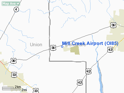
Location & QuickFacts
| FAA Information Effective: | 2008-09-25 |
| Airport Identifier: | OI85 |
| Airport Status: | Operational |
| Longitude/Latitude: | 083-13-17.6960W/40-16-06.2180N
-83.221582/40.268394 (Estimated) |
| Elevation: | 960 ft / 292.61 m (Estimated) |
| Land: | 0 acres |
| From nearest city: | 1 nautical miles W of Ostrander, OH |
| Location: | Delaware County, OH |
| Magnetic Variation: | 05W (1985) |
Owner & Manager
| Ownership: | Privately owned |
| Owner: | Frank T. Sayers |
| Address: | 266 W. North Street
Ostrander, OH 43061-9785 |
| Phone number: | 614-666-7652 |
| Manager: | Frank T Sayers |
| Address: | 266 W North Street
Ostrander, OH 43061-9785 |
| Phone number: | 419-285-2260 |
Airport Operations and Facilities
| Airport Use: | Private |
| Wind indicator: | Yes |
| Segmented Circle: | No |
| Control Tower: | No |
| Landing fee charge: | No |
| Sectional chart: | Detroit |
| Region: | AGL - Great Lakes |
| Boundary ARTCC: | ZID - Indianapolis |
| Tie-in FSS: | DAY - Dayton |
| FSS on Airport: | No |
| FSS Toll Free: | 1-800-WX-BRIEF |
Runway Information
Runway 18/36
| Dimension: | 1550 x 25 ft / 472.4 x 7.6 m |
| Surface: | TURF-GRVL, |
| |
Runway 18 |
Runway 36 |
| Traffic Pattern: | Left | Left |
| Obstruction: | 50 ft trees | |
|
Radio Navigation Aids
| ID |
Type |
Name |
Ch |
Freq |
Var |
Dist |
| DLZ | NDB | Delaware | | 215.00 | 06W | 5.5 nm |
| MRT | NDB | Marysville | | 403.00 | 05W | 6.4 nm |
| OS | NDB | Fuler | | 515.00 | 05W | 11.8 nm |
| DKG | NDB | Don Scott | | 348.00 | 05W | 13.1 nm |
| CHC | NDB | Grens | | 272.00 | 04W | 17.9 nm |
| MNN | NDB | Marion | | 201.00 | 05W | 22.1 nm |
| UYF | NDB | London | | 263.00 | 06W | 23.0 nm |
| RUV | NDB | Rushsylvania | | 326.00 | 05W | 23.4 nm |
| BU | NDB | Boutn | | 230.00 | 05W | 27.0 nm |
| CM | NDB | Sumie | | 391.00 | 05W | 27.4 nm |
| EDJ | NDB | Bellefontaine | | 242.00 | 05W | 27.8 nm |
| CCJ | NDB | Clark County | | 341.00 | 04W | 34.9 nm |
| HEH | NDB | Newark | | 524.00 | 06W | 37.8 nm |
| CSS | NDB | Court House | | 414.00 | 05W | 40.9 nm |
| LYL | NDB | Lima | | 362.00 | 04W | 45.1 nm |
| CYO | NDB | Circleville | | 366.00 | 05W | 46.2 nm |
| MF | NDB | Manns | | 372.00 | 06W | 46.4 nm |
| XEN | NDB | Xenia | | 395.00 | 03W | 46.6 nm |
| BNR | NDB | Benton Ridge | | 334.00 | 05W | 49.6 nm |
| TII | NDB | Tiffin | | 269.00 | 05W | 49.9 nm |
| LCK | TACAN | Rickenbacker | 069X | | 05W | 30.8 nm |
| XSF | TACAN | Springfield | 065X | | 04W | 38.5 nm |
| FFO | TACAN | Patterson | 099X | | 04W | 46.9 nm |
| BUD | VOR | Buckeye | | 109.80 | 05W | 22.1 nm |
| AOH | VOR | Allen County | | 108.40 | 04W | 43.1 nm |
| XUB | VOR | Yellow Bud | | 112.50 | 05W | 46.0 nm |
| MAH | VOR | Marathon | | 114.90 | 05W | 49.2 nm |
| SGH | VOR/DME | Springfield | 079X | 113.20 | 04W | 38.7 nm |
| APE | VORTAC | Appleton | 114X | 116.70 | 06W | 29.9 nm |
| ROD | VORTAC | Rosewood | 122X | 117.50 | 05W | 37.7 nm |
| MFD | VORTAC | Mansfield | 025X | 108.80 | 03W | 46.2 nm |
| FDY | VORTAC | Findlay | 019X | 108.20 | 02W | 48.0 nm |
| CMH | VOT | Port Columbus | | 111.00 | | 22.6 nm |
Images and information placed above are from
http://www.airport-data.com/airport/OI85/
We thank them for the data!
| General Info
|
| Country |
United States
|
| State |
OHIO
|
| FAA ID |
OI85
|
| Latitude |
40-16-06.218N
|
| Longitude |
083-13-17.696W
|
| Elevation |
960 feet
|
| Near City |
OSTRANDER
|
We don't guarantee the information is fresh and accurate. The data may
be wrong or outdated.
For more up-to-date information please refer to other sources.
|
|


