 |
|
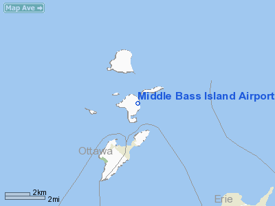
Middle Bass Island Airport |
Coordinates: 41°41′06″N 082°48′18″W / 41.685°N 82.805°W / 41.685; -82.805
| Middle Bass Island Airport |
| IATA: none – ICAO: none – FAA LID: 3T7 |
| Summary |
| Airport type |
Public |
| Owner |
Put-in-Bay Township Port Authority |
| Location |
Middle Bass Island, Ohio |
| Elevation AMSL |
580 ft / 177 m |
| Runways |
| Direction |
Length |
Surface |
| ft |
m |
| 10/28 |
1,852 |
564 |
Asphalt |
| Statistics (2005) |
| Aircraft operations |
6,500 |
| Source: Federal Aviation Administration |
Middle Bass Island Airport (FAA LID: 3T7) is a public airport located on Middle Bass Island in Ottawa County, Ohio, United States. It is owned by the Put-in-Bay Township Port Authority.
Facilities and aircraft
Middle Bass Island Airport has one asphalt paved runway (10/28) measuring 1,852 x 75 ft. (564 x 23 m). For the 12-month period ending October 18, 2005, the airport had 6,500 aircraft operations, an average of 17 per day: 62% air taxi (4,000) and 38% general aviation.
The above content comes from Wikipedia and is published under free licenses – click here to read more.
Location & QuickFacts
| FAA Information Effective: | 2008-09-25 |
| Airport Identifier: | 3T7 |
| Airport Status: | Operational |
| Longitude/Latitude: | 082-48-17.6390W/41-41-06.3290N
-82.804900/41.685091 (Estimated) |
| Elevation: | 580 ft / 176.78 m (Estimated) |
| Land: | 0 acres |
| From nearest city: | 1 nautical miles NE of Middle Bass Island, OH |
| Location: | Ottawa County, OH |
| Magnetic Variation: | 07W (2000) |
Owner & Manager
| Ownership: | Publicly owned |
| Owner: | Put-in-bay Twp Port Auth |
| Address: | Box 278
Put-in-bay, OH 43456 |
| Phone number: | 419-285-3371
ADDITIONAL PHONE NR 419-285-8042. |
| Manager: | Monica Drake |
| Address: | Box 278
Put-in-bay, OH 43456 |
| Phone number: | 419-285-3371 |
Airport Operations and Facilities
| Airport Use: | Open to public |
| Wind indicator: | Yes |
| Segmented Circle: | Yes |
| Control Tower: | No |
| Sectional chart: | Detroit |
| Region: | AGL - Great Lakes |
| Traffic Pattern Alt: | 1000 ft |
| Boundary ARTCC: | ZOB - Cleveland |
| Tie-in FSS: | CLE - Cleveland |
| FSS Toll Free: | 1-800-WX-BRIEF |
Airport Communications
| CTAF: | 122.800 |
| Unicom: | 122.800 |
Airport Services
Runway Information
Runway 10/28
| Dimension: | 1852 x 75 ft / 564.5 x 22.9 m |
| Surface: | ASPH, Good Condition |
| |
Runway 10 |
Runway 28 |
| Traffic Pattern: | Right | Left |
| Markings: | Basic, Good Condition | Basic, Good Condition |
| Displaced threshold: | 52.00 ft | 0.00 ft |
| VASI: | 4-light PAPI on left side | 4-light PAPI on left side |
| Obstruction: | 20 ft bldg, 372.0 ft from runway, 120 ft right of centerline, 8:1 slope to clear
APCH SLOPE 0:1 TO DSPLCD THLD DUE TO +48 FT TREES 200 FT FM DSPLCD THLD 144 FT R. | 6 ft gnd, 300.0 ft from runway, 16:1 slope to clear |
|
Radio Navigation Aids
| ID |
Type |
Name |
Ch |
Freq |
Var |
Dist |
| PT | NDB | Pelee Island | | 283.00 | 05W | 8.3 nm |
| PCW | NDB | Port Clinton | | 423.00 | 06W | 10.4 nm |
| RYS | NDB | Grosse Ile | | 419.00 | 06W | 29.5 nm |
| G | NDB | Golf | | 398.00 | 05W | 35.3 nm |
| QG | NDB | Windsor | | 353.00 | 06W | 37.8 nm |
| TII | NDB | Tiffin | | 269.00 | 05W | 39.7 nm |
| FZI | NDB | Fostoria | | 379.00 | 05W | 40.0 nm |
| VQ | NDB | Cargl | | 230.00 | 05W | 40.9 nm |
| CL | NDB | Harri | | 344.00 | 07W | 43.2 nm |
| 4L | NDB | Chatham | | 236.00 | 06W | 49.8 nm |
| TOL | TACAN | Toledo | 072X | | 05W | 45.0 nm |
| SKY | VOR/DME | Sandusky | 029X | 109.20 | 04W | 16.5 nm |
| YQG | VOR/DME | Windsor | 085X | 113.80 | 06W | 34.0 nm |
| DJB | VOR/DME | Dryer | 083X | 113.60 | 05W | 35.0 nm |
| VWV | VOR/DME | Waterville | 078X | 113.10 | 02W | 40.0 nm |
| DXO | VOR/DME | Detroit | 081X | 113.40 | 06W | 40.5 nm |
| CRL | VORTAC | Carleton | 104X | 115.70 | 03W | 36.5 nm |
| DTW | VOT | Detroit Met Wayne | | 109.80 | | 41.1 nm |
| DET | VOT | Detroit City | | 111.60 | | 44.3 nm |
| YIP | VOT | Willow Run | | 112.00 | | 46.0 nm |
| CLE | VOT | Cleveland | | 110.40 | | 46.1 nm |
Remarks
- ALL TFC PATTERNS REMAIN S OF ARPT.
- PRVDD ALL TFC PATTERNS REMAIN N OF ARPT, RY THLDS BE DSPLCD, R TFC RY 17 AT 3X5.
Images and information placed above are from
http://www.airport-data.com/airport/3T7/
We thank them for the data!
|
|


