 |
|
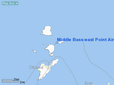
Middle Bass-east Point Airport |
Location & QuickFacts
| FAA Information Effective: | 2008-09-25 |
| Airport Identifier: | 3W9 |
| Airport Status: | Operational |
| Longitude/Latitude: | 082-47-47.6000W/41-41-40.0000N
-82.796556/41.694444 (Estimated) |
| Elevation: | 582 ft / 177.39 m (Surveyed) |
| Land: | 14 acres |
| From nearest city: | 1 nautical miles NE of Middle Bass Island, OH |
| Location: | Ottawa County, OH |
| Magnetic Variation: | 07W (2000) |
Owner & Manager
| Ownership: | Privately owned |
| Owner: | East Point Associates Inc |
| Address: | 2522 Norfolk Rd
Cleveland Heights, OH 44106 |
| Phone number: | 216-321-1847 |
| Manager: | W. B. Cleveland |
| Address: | Po Box 8
Middle Bass, OH 43446 |
| Phone number: | 216-321-1847 |
Airport Operations and Facilities
| Airport Use: | Open to public |
| Wind indicator: | Yes
WINDSOCK OTS INDEFLY. |
| Segmented Circle: | No |
| Control Tower: | No |
| Sectional chart: | Detroit |
| Region: | AGL - Great Lakes |
| Boundary ARTCC: | ZOB - Cleveland |
| Tie-in FSS: | CLE - Cleveland |
| FSS on Airport: | No |
| FSS Toll Free: | 1-800-WX-BRIEF |
| NOTAMs Facility: | CLE (NOTAM-d service avaliable) |
| Federal Agreements: | N |
Airport Communications
Airport Services
| Airframe Repair: | NONE |
| Power Plant Repair: | NONE |
| Bottled Oxygen: | NONE |
| Bulk Oxygen: | NONE |
Runway Information
Runway 09/27
| Dimension: | 2085 x 67 ft / 635.5 x 20.4 m |
| Surface: | TURF, Fair Condition |
| |
Runway 09 |
Runway 27 |
| Longitude: | 082-48-01.3034W | 082-47-33.8881W |
| Latitude: | 41-41-39.2225N | 41-41-40.7945N |
| Elevation: | 578.00 ft | 580.00 ft |
| Traffic Pattern: | Left | Right |
| Obstruction: | 3 ft berm, 33 ft left of centerline | 64 ft trees, 60.0 ft from runway, 65 ft left of centerline |
|
Radio Navigation Aids
| ID |
Type |
Name |
Ch |
Freq |
Var |
Dist |
| PT | NDB | Pelee Island | | 283.00 | 05W | 7.6 nm |
| PCW | NDB | Port Clinton | | 423.00 | 06W | 11.1 nm |
| RYS | NDB | Grosse Ile | | 419.00 | 06W | 29.2 nm |
| G | NDB | Golf | | 398.00 | 05W | 34.9 nm |
| QG | NDB | Windsor | | 353.00 | 06W | 37.3 nm |
| TII | NDB | Tiffin | | 269.00 | 05W | 40.4 nm |
| VQ | NDB | Cargl | | 230.00 | 05W | 40.4 nm |
| FZI | NDB | Fostoria | | 379.00 | 05W | 40.7 nm |
| CL | NDB | Harri | | 344.00 | 07W | 43.1 nm |
| 4L | NDB | Chatham | | 236.00 | 06W | 49.1 nm |
| EZE | NDB | Engel | | 226.00 | 07W | 49.8 nm |
| TOL | TACAN | Toledo | 072X | | 05W | 45.4 nm |
| SKY | VOR/DME | Sandusky | 029X | 109.20 | 04W | 16.9 nm |
| YQG | VOR/DME | Windsor | 085X | 113.80 | 06W | 33.4 nm |
| DJB | VOR/DME | Dryer | 083X | 113.60 | 05W | 35.0 nm |
| DXO | VOR/DME | Detroit | 081X | 113.40 | 06W | 40.3 nm |
| VWV | VOR/DME | Waterville | 078X | 113.10 | 02W | 40.6 nm |
| CRL | VORTAC | Carleton | 104X | 115.70 | 03W | 36.4 nm |
| DTW | VOT | Detroit Met Wayne | | 109.80 | | 40.9 nm |
| DET | VOT | Detroit City | | 111.60 | | 43.8 nm |
| YIP | VOT | Willow Run | | 112.00 | | 45.9 nm |
| CLE | VOT | Cleveland | | 110.40 | | 45.9 nm |
Remarks
- RWY SOFT & WET IN SPRING.
- NUMEROUS TREES & BLDGS IN CLOSE PROXIMITY OF RY.
- BE ALERT: EXPECT SIGNIFICANT WINDSHEAR AND TURBULENCE ON APPROACH AND DEPARTURE WHEN WINDS EXCEED 10 KNOTS SPEED.
- VFR ONLY
Images and information placed above are from
http://www.airport-data.com/airport/3W9/
We thank them for the data!
| General Info
|
| Country |
United States
|
| State |
OHIO
|
| FAA ID |
3W9
|
| Latitude |
41-41-40.000N
|
| Longitude |
082-47-47.600W
|
| Elevation |
582 feet
|
| Near City |
MIDDLE BASS ISLAND
|
We don't guarantee the information is fresh and accurate. The data may
be wrong or outdated.
For more up-to-date information please refer to other sources.
|
|


