|
|
| Metcalf Field |
| IATA: TDZ – ICAO: KTDZ – FAA LID: TDZ |
| Summary |
| Airport type |
Public |
| Owner |
Toledo-Lucas County Port Authority |
| Serves |
Toledo, Ohio |
| Location |
Wood County, Ohio |
| Elevation AMSL |
622 ft / 189.6 m |
| Coordinates |
41°33′53″N 083°28′56″W / 41.56472°N 83.48222°W / 41.56472; -83.48222 |
| Runways |
| Direction |
Length |
Surface |
| ft |
m |
| 4/22 |
3,800 |
1,158.2 |
Asphalt |
| 14/32 |
5,830 |
1,777 |
Asphalt |
| Statistics (2008) |
| Aircraft operations |
90,700 |
| Based aircraft |
102 |
| Source: Federal Aviation Administration |
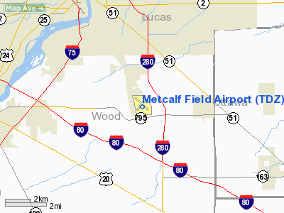
Metcalf Field (IATA: TDZ, ICAO: KTDZ, FAA LID: TDZ) is a public-use airport located 6 nautical miles (9.7 km) southeast of the central business district of Toledo, a city in Lucas County, Ohio, United States.
Facilities and aircraft
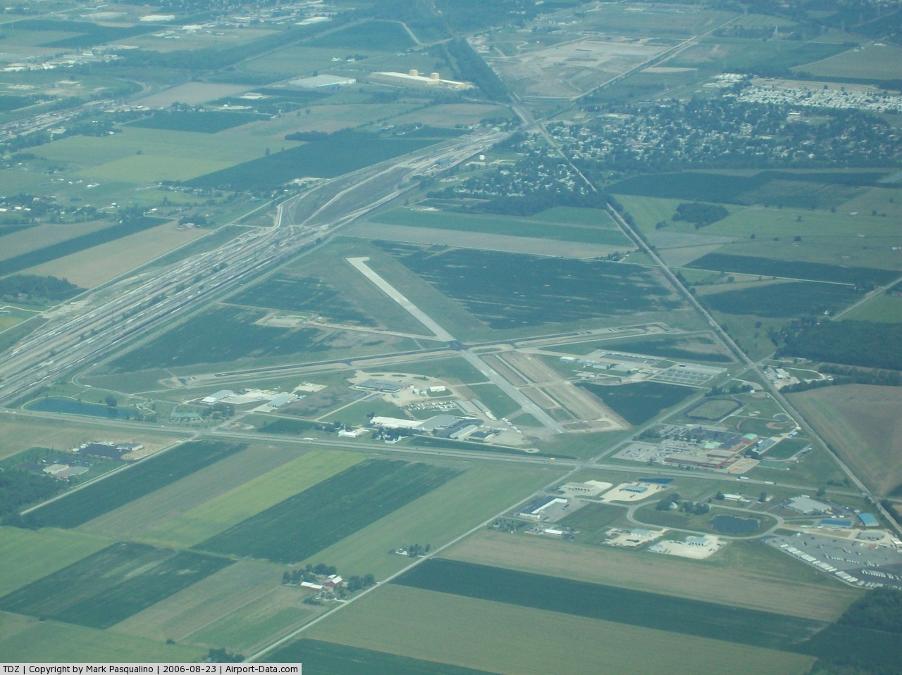
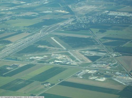
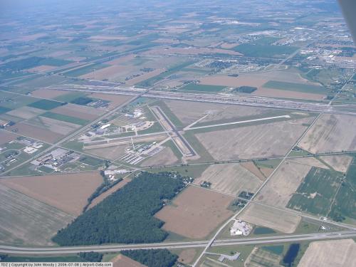
Metcalf Field has two runways designated 4/22 with a 3,800 by 75 ft (1,158.2 x 22.9 m) asphalt pavement, and 14/32 with a 5,830 by 100 ft (1,777 x 30.5 m) asphalt pavement. For the 12-month period ending December 4, 2006, the airport had 90,700 aircraft operations, an average of 248 per day: 77% general aviation, 22% air taxi and <1% military. At that time there were 102 aircraft based at this airport: 80% single-engine, 18% multi-engine, 1% jet and 1% helicopter.
The above content comes from Wikipedia and is published under free licenses – click here to read more.
 |
(Click on the photo to enlarge) |
 |
(Click on the photo to enlarge) |
Location & QuickFacts
| FAA Information Effective: | 2008-09-25 |
| Airport Identifier: | TDZ |
| Airport Status: | Operational |
| Longitude/Latitude: | 083-28-56.1410W/41-33-53.5390N
-83.482261/41.564872 (Estimated) |
| Elevation: | 622 ft / 189.59 m (Surveyed) |
| Land: | 450 acres |
| From nearest city: | 6 nautical miles SE of Toledo, OH |
| Location: | Wood County, OH |
| Magnetic Variation: | 02W (1975) |
Owner & Manager
| Ownership: | Publicly owned |
| Owner: | Toledo Lucas Co.port Auth. |
| Address: | One Maritime Plaza
Toledo, OH 43604 |
| Phone number: | 419-243-8251 |
| Manager: | Paul Toth
DRCTR OF ARPTS, TOLEDO PORT AUTH 419-865-2351, EXPRESS ARPT. |
| Address: | 11013 Airport Hwy Box 11
Swanton, OH 43558
APT ADDRESS: 28331 LEMOYNE RD, MILLBURY, OH 43447. |
| Phone number: | 419-865-2351
APT PHONE:419-838-6921. |
Airport Operations and Facilities
| Airport Use: | Open to public |
| Wind indicator: | Yes |
| Segmented Circle: | No |
| Control Tower: | No |
| Lighting Schedule: | DUSK-DAWN
ACTVT REIL RYS 04 & 22 - CTAF. |
| Beacon Color: | Clear-Green (lighted land airport) |
| Landing fee charge: | Yes |
| Sectional chart: | Detroit |
| Region: | AGL - Great Lakes |
| Boundary ARTCC: | ZOB - Cleveland |
| Tie-in FSS: | CLE - Cleveland |
| FSS on Airport: | No |
| FSS Toll Free: | 1-800-WX-BRIEF |
| NOTAMs Facility: | TDZ (NOTAM-d service avaliable) |
| Federal Agreements: | NGY |
Airport Communications
| CTAF: | 123.050 |
| Unicom: | 123.050 |
Airport Services
| Fuel available: | 100LLA |
| Airframe Repair: | MAJOR |
| Power Plant Repair: | MAJOR |
| Bottled Oxygen: | HIGH |
| Bulk Oxygen: | HIGH |
Runway Information
Runway 04/22
| Dimension: | 3800 x 75 ft / 1158.2 x 22.9 m |
| Surface: | ASPH, |
| Weight Limit: | Single wheel: 63000 lbs.
Dual wheel: 85000 lbs.
PER ARPT MGR BOTH RWYS. |
| Edge Lights: | Medium |
| |
Runway 04 |
Runway 22 |
| Longitude: | 083-29-10.5070W | 083-28-39.1810W |
| Latitude: | 41-33-36.1030N | 41-34-05.3600N |
| Elevation: | 622.00 ft | 621.00 ft |
| Alignment: | 39 | 127 |
| Traffic Pattern: | Left | Left |
| Markings: | Non-precision instrument, Fair Condition | Non-precision instrument, Fair Condition |
| Crossing Height: | 45.00 ft | 39.00 ft |
| Displaced threshold: | 100.00 ft | 380.00 ft |
| VASI: | 4-box on left side
VASI OTS INDEFLY. | 4-box on right side |
| Visual Glide Angle: | 3.00° | 3.00° |
| Runway End Identifier: | Yes | Yes |
| Centerline Lights: | No | No |
| Touchdown Lights: | No | No |
| Obstruction: | 15 ft road, 412.0 ft from runway, 280 ft right of centerline, 14:1 slope to clear
RUNWAY APPROACH RATIO 20:1 TO DISPLACED THRESHOLD. | 29 ft rr, 361.0 ft from runway, 262 ft left of centerline, 5:1 slope to clear
RWY 22 APCH RATIO 25:1 TO DSPLCD THLD DUE TO +29 FT RR 737 FT FM DSPLCD THLD 308 FT L. |
|
Runway 14/32
| Dimension: | 5830 x 100 ft / 1777.0 x 30.5 m |
| Surface: | ASPH, Good Condition |
| Surface Treatment: | Saw-cut or plastic Grooved |
| Weight Limit: | Single wheel: 63000 lbs.
Dual wheel: 85000 lbs.
PER ARPT MGR BOTH RWYS. |
| Edge Lights: | Medium |
| |
Runway 14 |
Runway 32 |
| Longitude: | 083-29-24.4300W | 083-28-29.2640W |
| Latitude: | 41-34-15.7800N | 41-33-35.7800N |
| Elevation: | 622.00 ft | 621.00 ft |
| Alignment: | 127 | 127 |
| Traffic Pattern: | Left | Left |
| Markings: | Basic, Good Condition | Basic, Good Condition |
| Crossing Height: | 34.00 ft | 43.00 ft |
| Displaced threshold: | 580.00 ft | 580.00 ft |
| VASI: | 4-light PAPI on left side | 4-box on left side |
| Visual Glide Angle: | 3.00° | 3.00° |
| Runway End Identifier: | Yes | No |
| Centerline Lights: | No | No |
| Touchdown Lights: | No | No |
| Obstruction: | 44 ft twr, 703.0 ft from runway, 159 ft right of centerline, 11:1 slope to clear
RUNWAY 14 APPROACH RATIO 29:1 TO DISPLACED THRESHOLD. | 17 ft road, 348.0 ft from runway, 252 ft right of centerline, 8:1 slope to clear
RUNWAY 32 APPROACH RATIO 48:1 TO DISPLACED THRESHOLD. |
| Decleard distances: | Take off run available 4600.00 ft
Take off distance available 4600.00 ft
Actual stop distance available 5242.00 ft
Landing distance available 4680.00 ft
| Take off run available 5268.00 ft
Take off distance available 5268.00 ft
Actual stop distance available 5268.00 ft
Landing distance available 4680.00 ft
|
|
Radio Navigation Aids
| ID |
Type |
Name |
Ch |
Freq |
Var |
Dist |
| FZI | NDB | Fostoria | | 379.00 | 05W | 22.9 nm |
| PCW | NDB | Port Clinton | | 423.00 | 06W | 27.7 nm |
| USE | NDB | Fulton | | 375.00 | 05W | 29.4 nm |
| TII | NDB | Tiffin | | 269.00 | 05W | 30.7 nm |
| ADG | NDB | Adrian | | 278.00 | 06W | 32.4 nm |
| TCU | NDB | Tecumseh | | 239.00 | 04W | 33.5 nm |
| BNR | NDB | Benton Ridge | | 334.00 | 05W | 33.8 nm |
| RYS | NDB | Grosse Ile | | 419.00 | 06W | 35.4 nm |
| PT | NDB | Pelee Island | | 283.00 | 05W | 38.7 nm |
| PDR | NDB | Ottawa | | 233.00 | 05W | 39.0 nm |
| BYN | NDB | Bryan | | 260.00 | 04W | 44.6 nm |
| DFI | NDB | Defiance | | 246.00 | 05W | 44.8 nm |
| G | NDB | Golf | | 398.00 | 05W | 45.2 nm |
| TOL | TACAN | Toledo | 072X | | 05W | 14.4 nm |
| MAH | VOR | Marathon | | 114.90 | 05W | 34.1 nm |
| VWV | VOR/DME | Waterville | 078X | 113.10 | 02W | 9.8 nm |
| SKY | VOR/DME | Sandusky | 029X | 109.20 | 04W | 38.1 nm |
| DXO | VOR/DME | Detroit | 081X | 113.40 | 06W | 39.3 nm |
| CRL | VORTAC | Carleton | 104X | 115.70 | 03W | 29.1 nm |
| FDY | VORTAC | Findlay | 019X | 108.20 | 02W | 38.7 nm |
| DTW | VOT | Detroit Met Wayne | | 109.80 | | 40.2 nm |
| YIP | VOT | Willow Run | | 112.00 | | 40.3 nm |
Remarks
- PARALLEL TWY RY 04/22 & 14/32 35 FT WIDE.
- ERIC BARNUM ARPT FIELD CTC - 419-838-6921.
- SEAGULLS ON & INVOF ARPT.
- IN OPERS PRIOR TO 1959.
Images and information placed above are from
http://www.airport-data.com/airport/TDZ/
We thank them for the data!
| General Info
|
| Country |
United States
|
| State |
OHIO
|
| FAA ID |
TDZ
|
| Latitude |
41-33-53.539N
|
| Longitude |
083-28-56.141W
|
| Elevation |
622 feet
|
| Near City |
TOLEDO
|
We don't guarantee the information is fresh and accurate. The data may
be wrong or outdated.
For more up-to-date information please refer to other sources.
|
|