 |
|
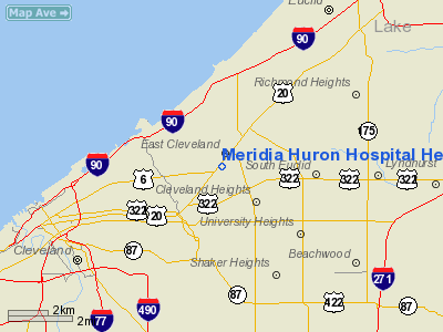
Meridia Huron Hospital Heliport |
Location & QuickFacts
| FAA Information Effective: | 2008-09-25 |
| Airport Identifier: | 8OI8 |
| Airport Status: | Operational |
| Longitude/Latitude: | 081-35-05.2900W/41-31-33.5000N
-81.584803/41.525972 (Estimated) |
| Elevation: | 715 ft / 217.93 m (Estimated) |
| Land: | 0 acres |
| From nearest city: | 1 nautical miles W of East Cleveland, OH |
| Location: | Cuyahoga County, OH |
| Magnetic Variation: | 07W (1985) |
Owner & Manager
| Ownership: | Privately owned |
| Owner: | Meridia Huron Hospital |
| Address: | 13951 Terrace Road
East Cleveland, OH 44112 |
| Phone number: | 216-761-3300 |
| Manager: | Christopher Manacci |
| Address: | Cleveland Clinic, 9500 Euclid Ave
Cleveland, OH 44195 |
| Phone number: | 216-445-4595 |
Airport Operations and Facilities
| Airport Use: | Private
MEDICAL USE. |
| Wind indicator: | Yes |
| Segmented Circle: | No |
| Control Tower: | No |
| Lighting Schedule: | DUSK-DAWN |
| Beacon Color: | Clear-Green-Yellow (heliport) |
| Landing fee charge: | No |
| Sectional chart: | Detroit |
| Region: | AGL - Great Lakes |
| Boundary ARTCC: | ZOB - Cleveland |
| Tie-in FSS: | CLE - Cleveland |
| FSS on Airport: | No |
| FSS Toll Free: | 1-800-WX-BRIEF |
Runway Information
Helipad H1
| Dimension: | 45 x 45 ft / 13.7 x 13.7 m |
| Surface: | ASPH, |
| |
Runway H1 |
Runway |
| Traffic Pattern: | Left | Left |
|
Radio Navigation Aids
| ID |
Type |
Name |
Ch |
Freq |
Var |
Dist |
| BKL | NDB | Burke Lakefront | | 416.00 | 07W | 3.5 nm |
| EZE | NDB | Engel | | 226.00 | 07W | 6.6 nm |
| LQL | NDB | Lakeland | | 263.00 | 08W | 13.2 nm |
| CL | NDB | Harri | | 344.00 | 07W | 20.5 nm |
| AK | NDB | Akron | | 362.00 | 07W | 28.8 nm |
| AAU | NDB | Ashland | | 329.00 | 07W | 45.4 nm |
| LNN | VOR/DME | Lost Nation | 039X | 110.20 | 08W | 12.9 nm |
| CXR | VOR/DME | Chardon | 074X | 112.70 | 05W | 19.0 nm |
| DJB | VOR/DME | Dryer | 083X | 113.60 | 05W | 27.9 nm |
| ACO | VOR/DME | Akron | 091X | 114.40 | 04W | 30.5 nm |
| JFN | VOR/DME | Jefferson | 099X | 115.20 | 05W | 40.1 nm |
| BSV | VOR/DME | Briggs | 071X | 112.40 | 04W | 47.7 nm |
| SKY | VOR/DME | Sandusky | 029X | 109.20 | 04W | 48.5 nm |
| YNG | VORTAC | Youngstown | 027X | 109.00 | 05W | 42.7 nm |
| CLE | VOT | Cleveland | | 110.40 | | 13.8 nm |
| CAK | VOT | Akron/canton Regional | | 110.60 | | 37.2 nm |
Remarks
- APP/DEP OPERATIONS FROM AREA 170 DEG - 220 DEG; AREA APPROPRIATELY MARKED; WIND INDICATOR MAINTAINED.
Images and information placed above are from
http://www.airport-data.com/airport/8OI8/
We thank them for the data!
| General Info
|
| Country |
United States
|
| State |
OHIO
|
| FAA ID |
8OI8
|
| Latitude |
41-31-31.184N
|
| Longitude |
081-35-01.450W
|
| Elevation |
720 feet
|
| Near City |
EAST CLEVELAND
|
We don't guarantee the information is fresh and accurate. The data may
be wrong or outdated.
For more up-to-date information please refer to other sources.
|
|


