 |
|
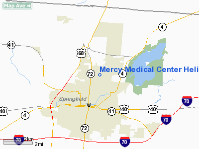
Mercy Medical Center Heliport |
Location & QuickFacts
| FAA Information Effective: | 2008-09-25 |
| Airport Identifier: | 6OH0 |
| Airport Status: | Operational |
| Longitude/Latitude: | 083-47-29.7410W/39-57-30.2150N
-83.791595/39.958393 (Estimated) |
| Elevation: | 1021 ft / 311.20 m (Estimated) |
| Land: | 0 acres |
| From nearest city: | 2 nautical miles N of Springfield, OH |
| Location: | Clark County, OH |
| Magnetic Variation: | 04W (1985) |
Owner & Manager
| Ownership: | Privately owned |
| Owner: | Mercy Medical Center |
| Address: | 1343 North Fountain Blvd
Springfield, OH 45501 |
| Phone number: | 513-390-5056 |
| Manager: | Ronald D. Himes, Vice Pres. |
| Address: | 1343 North Fountain Blvd
Springfield, OH 45501 |
| Phone number: | 513-390-5056 |
Airport Operations and Facilities
| Airport Use: | Private
MEDICAL USE. |
| Wind indicator: | Yes |
| Segmented Circle: | No |
| Control Tower: | No |
| Lighting Schedule: | PHONE REQ
FOR BCN AND PERIMETER LGTS CALL 513-390-5056. |
| Beacon Color: | Clear-Yellow (lighted seaplan base) |
| Sectional chart: | Cincinnati |
| Region: | AGL - Great Lakes |
| Boundary ARTCC: | ZID - Indianapolis |
| Tie-in FSS: | DAY - Dayton |
| FSS Toll Free: | 1-800-WX-BRIEF |
Runway Information
Helipad H1
| Dimension: | 40 x 40 ft / 12.2 x 12.2 m |
| Surface: | CONC, |
| |
Runway H1 |
Runway |
| Traffic Pattern: | Left | Left |
|
Radio Navigation Aids
| ID |
Type |
Name |
Ch |
Freq |
Var |
Dist |
| CCJ | NDB | Clark County | | 341.00 | 04W | 5.1 nm |
| UYF | NDB | London | | 263.00 | 06W | 15.1 nm |
| XEN | NDB | Xenia | | 395.00 | 03W | 15.9 nm |
| EDJ | NDB | Bellefontaine | | 242.00 | 05W | 24.8 nm |
| MRT | NDB | Marysville | | 403.00 | 05W | 25.9 nm |
| IL | NDB | Airbo | | 407.00 | 04W | 28.2 nm |
| OS | NDB | Fuler | | 515.00 | 05W | 28.2 nm |
| BU | NDB | Boutn | | 230.00 | 05W | 28.3 nm |
| CSS | NDB | Court House | | 414.00 | 05W | 28.3 nm |
| RUV | NDB | Rushsylvania | | 326.00 | 05W | 30.6 nm |
| DKG | NDB | Don Scott | | 348.00 | 05W | 33.6 nm |
| CHC | NDB | Grens | | 272.00 | 04W | 35.3 nm |
| HW | NDB | Cubla | | 299.00 | 04W | 36.6 nm |
| VES | NDB | Versailles | | 356.00 | 04W | 36.8 nm |
| DLZ | NDB | Delaware | | 215.00 | 06W | 37.0 nm |
| HKF | NDB | Hook Field | | 239.00 | 04W | 41.0 nm |
| CYO | NDB | Circleville | | 366.00 | 05W | 45.7 nm |
| LYL | NDB | Lima | | 362.00 | 04W | 46.1 nm |
| RZT | NDB | Ross County | | 236.00 | 05W | 47.1 nm |
| CQA | NDB | Lakefield | | 205.00 | 04W | 47.4 nm |
| CM | NDB | Sumie | | 391.00 | 05W | 47.8 nm |
| HOC | NDB | Hillsboro | | 278.00 | 05W | 47.9 nm |
| XSF | TACAN | Springfield | 065X | | 04W | 7.6 nm |
| FFO | TACAN | Patterson | 099X | | 04W | 14.8 nm |
| LCK | TACAN | Rickenbacker | 069X | | 05W | 40.8 nm |
| XUB | VOR | Yellow Bud | | 112.50 | 05W | 45.7 nm |
| AOH | VOR | Allen County | | 108.40 | 04W | 45.7 nm |
| SGH | VOR/DME | Springfield | 079X | 113.20 | 04W | 7.7 nm |
| DQN | VOR/DME | Dayton | 092X | 114.50 | 01W | 28.1 nm |
| MXQ | VOR/DME | Midwest | 076X | 112.90 | 04W | 31.8 nm |
| ROD | VORTAC | Rosewood | 122X | 117.50 | 05W | 22.9 nm |
| RID | VORTAC | Richmond | 043X | 110.60 | 03W | 49.8 nm |
| DAY | VOT | Dayton J M Cox-day | | 111.00 | | 20.0 nm |
| CMH | VOT | Port Columbus | | 111.00 | | 41.8 nm |
Remarks
- PROVIDED THAT APCH/DEP OPNS CONDUCTED IN 340 DEG TO 225 DEG; TAKEOFF/LNDG APPROPRIATELY MARKED, MAINTAIN WIND INDICATOR.
Images and information placed above are from
http://www.airport-data.com/airport/6OH0/
We thank them for the data!
| General Info
|
| Country |
United States
|
| State |
OHIO
|
| FAA ID |
6OH0
|
| Latitude |
39-57-30.215N
|
| Longitude |
083-47-29.741W
|
| Elevation |
1021 feet
|
| Near City |
SPRINGFIELD
|
We don't guarantee the information is fresh and accurate. The data may
be wrong or outdated.
For more up-to-date information please refer to other sources.
|
|


