 |
|
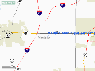
| Medina Municipal Airport |
| IATA: none – ICAO: none – FAA LID: 1G5 |
| Summary |
| Airport type |
Public |
| Owner |
City of Medina |
| Serves |
Medina, Ohio |
| Elevation AMSL |
1,190 ft / 363 m |
| Coordinates |
41°07′53.2″N 081°45′53.7″W / 41.131444°N 81.764917°W / 41.131444; -81.764917 |
| Runways |
| Direction |
Length |
Surface |
| ft |
m |
| 01/19 |
2,867 |
874 |
Asphalt |
| 09/27 |
3,556 |
1,084 |
Asphalt |
| Statistics (2008) |
| Aircraft operations |
79,685 |
| Based aircraft |
65 |
| Source: Federal Aviation Administration |
Medina Municipal Airport is a public use airport in Medina County, Ohio, United States. It is owned by the City of Medina and is located four nautical miles (7.41 km) east of the central business district. According to the FAA's National Plan of Integrated Airport Systems for 2007-2011, it is categorized as a reliever airport.
Although most U.S. airports use the same three-letter location identifier for the FAA and IATA, this airport is assigned 1G5 by the FAA but has no designation from the IATA.
Facilities and aircraft
Medina Municipal Airport covers an area of 283 acres (114.5 ha) at an elevation of 1,190 feet (363 m) above mean sea level. It has two asphalt runways designated 01/19, with a surface measuring 2,867 by 60 feet (874 x 18 m) and 09/27, with a surface measuring 3,556 by 75 feet (1,084 x 23 m).
For the 12-month period ending July 18, 2008, the airport had 79,685 aircraft operations, an average of 218 per day: 98% general aviation, 2% air taxi, and a few military and ultralight. At that time there were 65 aircraft based at this airport: 80% single-engine, 11% multi-engine, 3% helicopters and 6% ultralights.
The above content comes from Wikipedia and is published under free licenses – click here to read more.
Location & QuickFacts
| FAA Information Effective: | 2008-09-25 |
| Airport Identifier: | 1G5 |
| Airport Status: | Operational |
| Longitude/Latitude: | 081-45-53.7000W/41-07-53.2000N
-81.764917/41.131444 (Estimated) |
| Elevation: | 1190 ft / 362.71 m (Surveyed) |
| Land: | 283 acres |
| From nearest city: | 4 nautical miles E of Medina, OH |
| Location: | Medina County, OH |
| Magnetic Variation: | 07W (1990) |
Owner & Manager
| Ownership: | Publicly owned |
| Owner: | City Of Medina |
| Address: | P O Box 703
Medina, OH 44258 |
| Phone number: | 330-725-8861 |
| Manager: | Eric Olson - Greg Huber |
| Address: | P O Box 703
Medina, OH 44258 |
| Phone number: | 330-725-6666 |
Airport Operations and Facilities
| Airport Use: | Open to public |
| Wind indicator: | Yes |
| Segmented Circle: | Yes |
| Control Tower: | No |
| Lighting Schedule: | DUSK-DAWN
MIRL RY 09/27, MIRL RY 01/19, PAPI RYS 09, 27, 01, & 19 OPER DUSK-2200; AFTER 2200 ACTVT - CTAF. |
| Beacon Color: | Clear-Green (lighted land airport) |
| Landing fee charge: | No |
| Sectional chart: | Detroit |
| Region: | AGL - Great Lakes |
| Boundary ARTCC: | ZOB - Cleveland |
| Tie-in FSS: | CLE - Cleveland |
| FSS on Airport: | No |
| FSS Toll Free: | 1-800-WX-BRIEF |
| NOTAMs Facility: | CLE (NOTAM-d service avaliable) |
| Federal Agreements: | NGY |
Airport Communications
| CTAF: | 123.000 |
| Unicom: | 123.000 |
Airport Services
| Fuel available: | 100LL |
| Airframe Repair: | MAJOR |
| Power Plant Repair: | MAJOR |
Runway Information
Runway 01/19
| Dimension: | 2867 x 60 ft / 873.9 x 18.3 m |
| Surface: | ASPH, Good Condition
RY HAS SEVERE CRACKING WITH MUCH FOD POTENTIAL. |
| Weight Limit: | Single wheel: 25000 lbs. |
| Edge Lights: | Medium |
| |
Runway 01 |
Runway 19 |
| Longitude: | 081-45-43.0980W | 081-45-42.4364W |
| Latitude: | 41-07-37.0182N | 41-08-05.3378N |
| Elevation: | 1170.00 ft | 1190.00 ft |
| Alignment: | 1 | 127 |
| Traffic Pattern: | Left | Left |
| Displaced threshold: | 0.00 ft | 737.00 ft
RWY 19 APCH RATIO 26:1 TO DSPLCD THLD DUE TO +74 FT TREES 1940 FT FM DSPLCD THLD. |
| VASI: | 4-light PAPI on left side | 4-light PAPI on left side |
| Obstruction: | 15 ft pline, 460.0 ft from runway, 17:1 slope to clear | 50 ft trees, 615.0 ft from runway, 159 ft left of centerline, 8:1 slope to clear |
|
Runway 09/27
| Dimension: | 3556 x 75 ft / 1083.9 x 22.9 m |
| Surface: | ASPH, Poor Condition
RY HAS SEVERE CRACKING WITH MUCH FOD POTENTIAL. |
| Weight Limit: | Single wheel: 30000 lbs. |
| Edge Lights: | Medium |
| |
Runway 09 |
Runway 27 |
| Longitude: | 081-46-25.5060W | 081-45-39.3308W |
| Latitude: | 41-07-52.8951N | 41-07-56.7892N |
| Elevation: | 1169.00 ft | 1183.00 ft |
| Alignment: | 84 | 127 |
| Traffic Pattern: | Left | Left |
| Markings: | Non-precision instrument, Good Condition | Non-precision instrument, Good Condition |
| Crossing Height: | 0.00 ft | 30.00 ft |
| VASI: | 4-light PAPI on left side
PAPI OTS INDEFLY. | 4-light PAPI on left side |
| Visual Glide Angle: | 0.00° | 3.50° |
| Runway End Identifier: | | Yes |
| Obstruction: | 109 ft trees, 1810.0 ft from runway, 365 ft right of centerline, 14:1 slope to clear | 52 ft trees, 1204.0 ft from runway, 390 ft right of centerline, 19:1 slope to clear |
|
Radio Navigation Aids
| ID |
Type |
Name |
Ch |
Freq |
Var |
Dist |
| CL | NDB | Harri | | 344.00 | 07W | 15.4 nm |
| AK | NDB | Akron | | 362.00 | 07W | 17.5 nm |
| EZE | NDB | Engel | | 226.00 | 07W | 21.6 nm |
| BKL | NDB | Burke Lakefront | | 416.00 | 07W | 24.3 nm |
| AAU | NDB | Ashland | | 329.00 | 07W | 24.3 nm |
| MLR | NDB | Millersburg/dcmsnd | | 382.00 | 06W | 35.8 nm |
| LQL | NDB | Lakeland | | 263.00 | 08W | 37.4 nm |
| MF | NDB | Manns | | 372.00 | 06W | 37.9 nm |
| TSO | NDB | Tolson | | 395.00 | 07W | 46.3 nm |
| DJB | VOR/DME | Dryer | 083X | 113.60 | 05W | 22.5 nm |
| ACO | VOR/DME | Akron | 091X | 114.40 | 04W | 25.6 nm |
| BSV | VOR/DME | Briggs | 071X | 112.40 | 04W | 27.9 nm |
| CXR | VOR/DME | Chardon | 074X | 112.70 | 05W | 35.7 nm |
| LNN | VOR/DME | Lost Nation | 039X | 110.20 | 08W | 37.3 nm |
| TVT | VOR/DME | Tiverton | 112X | 116.50 | 03W | 43.7 nm |
| SKY | VOR/DME | Sandusky | 029X | 109.20 | 04W | 44.1 nm |
| MFD | VORTAC | Mansfield | 025X | 108.80 | 03W | 40.7 nm |
| CLE | VOT | Cleveland | | 110.40 | | 17.2 nm |
| CAK | VOT | Akron/canton Regional | | 110.60 | | 19.5 nm |
Remarks
- DEER ON & INVOF ARPT.
- PAEW TWYS.
Images and information placed above are from
http://www.airport-data.com/airport/1G5/
We thank them for the data!
| General Info
|
| Country |
United States
|
| State |
OHIO
|
| FAA ID |
1G5
|
| Latitude |
41-07-53.200N
|
| Longitude |
081-45-53.700W
|
| Elevation |
1190 feet
|
| Near City |
MEDINA
|
We don't guarantee the information is fresh and accurate. The data may
be wrong or outdated.
For more up-to-date information please refer to other sources.
|
|


