 |
|
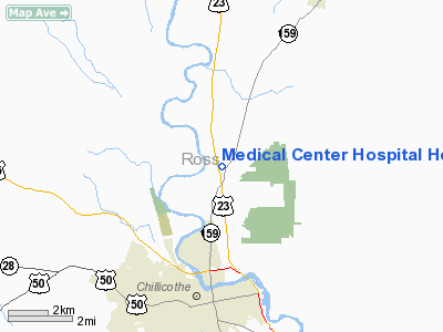
Medical Center Hospital Heliport |
Location & QuickFacts
| FAA Information Effective: | 2008-09-25 |
| Airport Identifier: | OH46 |
| Airport Status: | Operational |
| Longitude/Latitude: | 082-58-09.6470W/39-23-44.2280N
-82.969346/39.395619 (Estimated) |
| Elevation: | 745 ft / 227.08 m (Surveyed) |
| Land: | 0 acres |
| From nearest city: | 8 nautical miles N of Chillicothe, OH |
| Location: | Ross County, OH |
| Magnetic Variation: | 05W (1985) |
Owner & Manager
| Ownership: | Privately owned |
| Owner: | Medical Center Hospital |
| Address: | 272 Hospital Road
Chillicothe, OH 45601 |
| Phone number: | 614-772-7500 |
| Manager: | John Raterman
DIR PLANT OPERNS. |
| Address: | P.o. Box 708, Station A
Chillicothe, OH 45601 |
| Phone number: | 614-772-7502 |
Airport Operations and Facilities
| Airport Use: | Private
MEDICAL USE. |
| Wind indicator: | Yes |
| Segmented Circle: | No |
| Control Tower: | No |
| Landing fee charge: | No |
| Sectional chart: | Cincinnati |
| Region: | AGL - Great Lakes |
| Boundary ARTCC: | ZID - Indianapolis |
| Tie-in FSS: | DAY - Dayton |
| FSS on Airport: | No |
| FSS Toll Free: | 1-800-WX-BRIEF |
Airport Services
| Airframe Repair: | NONE |
| Power Plant Repair: | NONE |
Runway Information
Helipad H1
| Dimension: | 20 x 20 ft / 6.1 x 6.1 m |
| Surface: | ASPH, |
| |
Runway H1 |
Runway |
| Traffic Pattern: | Left | Left |
|
Radio Navigation Aids
| ID |
Type |
Name |
Ch |
Freq |
Var |
Dist |
| RZT | NDB | Ross County | | 236.00 | 05W | 3.8 nm |
| CYO | NDB | Circleville | | 366.00 | 05W | 7.7 nm |
| EOP | NDB | Waverly | | 385.00 | 06W | 13.9 nm |
| CSS | NDB | Court House | | 414.00 | 05W | 23.1 nm |
| BU | NDB | Boutn | | 230.00 | 05W | 27.7 nm |
| HOC | NDB | Hillsboro | | 278.00 | 05W | 29.5 nm |
| PZO | NDB | Peebles | | 329.00 | 02W | 33.0 nm |
| IL | NDB | Airbo | | 407.00 | 04W | 36.1 nm |
| CM | NDB | Sumie | | 391.00 | 05W | 36.9 nm |
| CHC | NDB | Grens | | 272.00 | 04W | 37.0 nm |
| PMH | NDB | Portsmouth | | 373.00 | 04W | 37.4 nm |
| UYF | NDB | London | | 263.00 | 06W | 39.7 nm |
| UGS | NDB | University | | 250.00 | 06W | 40.1 nm |
| DKG | NDB | Don Scott | | 348.00 | 05W | 41.5 nm |
| OS | NDB | Fuler | | 515.00 | 05W | 42.1 nm |
| HW | NDB | Cubla | | 299.00 | 04W | 42.2 nm |
| AMT | NDB | West Union | | 359.00 | 04W | 42.7 nm |
| HEH | NDB | Newark | | 524.00 | 06W | 44.5 nm |
| CCJ | NDB | Clark County | | 341.00 | 04W | 47.2 nm |
| XEN | NDB | Xenia | | 395.00 | 03W | 48.5 nm |
| LCK | TACAN | Rickenbacker | 069X | | 05W | 24.9 nm |
| XSF | TACAN | Springfield | 065X | | 04W | 48.3 nm |
| XUB | VOR | Yellow Bud | | 112.50 | 05W | 7.9 nm |
| MXQ | VOR/DME | Midwest | 076X | 112.90 | 04W | 38.7 nm |
| SGH | VOR/DME | Springfield | 079X | 113.20 | 04W | 48.4 nm |
| YRK | VORTAC | York | 075X | 112.80 | 05W | 45.2 nm |
| APE | VORTAC | Appleton | 114X | 116.70 | 06W | 48.7 nm |
| CMH | VOT | Port Columbus | | 111.00 | | 36.2 nm |
Remarks
- PRVDD ALL OPNS ARE CONDUCTED FM 100 DEG TO 360 DEG; AREA IS MKD; WIND INDICATOR IS MAINTAINED.
Images and information placed above are from
http://www.airport-data.com/airport/OH46/
We thank them for the data!
| General Info
|
| Country |
United States
|
| State |
OHIO
|
| FAA ID |
OH46
|
| Latitude |
39-23-44.228N
|
| Longitude |
082-58-09.647W
|
| Elevation |
745 feet
|
| Near City |
CHILLICOTHE
|
We don't guarantee the information is fresh and accurate. The data may
be wrong or outdated.
For more up-to-date information please refer to other sources.
|
|


