 |
|
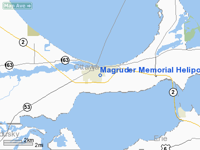
Magruder Memorial Heliport |
Location & QuickFacts
| FAA Information Effective: | 2008-09-25 |
| Airport Identifier: | 2OH1 |
| Airport Status: | Operational |
| Longitude/Latitude: | 082-55-57.6900W/41-30-20.1830N
-82.932692/41.505606 (Estimated) |
| Elevation: | 580 ft / 176.78 m (Estimated) |
| Land: | 5 acres |
| From nearest city: | 1 nautical miles N of Port Clinton, OH |
| Location: | Ottawa County, OH |
| Magnetic Variation: | 07W (2000) |
Owner & Manager
| Ownership: | Privately owned |
| Owner: | Magruder Memorial Hospital |
| Address: | 615 Fulton Street
Port Clinton, OH 43452 |
| Phone number: | 419-734-3131 |
| Manager: | Robert Dumminger |
| Address: | 615 Fulton Street
Port Clinton, OH 43452 |
Airport Operations and Facilities
| Airport Use: | Private
MEDICAL USE. |
| Wind indicator: | Yes |
| Segmented Circle: | No |
| Control Tower: | No |
| Sectional chart: | Detroit |
| Region: | AGL - Great Lakes |
| Boundary ARTCC: | ZOB - Cleveland |
| Tie-in FSS: | CLE - Cleveland |
| FSS Toll Free: | 1-800-WX-BRIEF |
Runway Information
Helipad H1
| Dimension: | 50 x 50 ft / 15.2 x 15.2 m |
| Surface: | CONC, |
| |
Runway H1 |
Runway |
| Traffic Pattern: | Left | Left |
|
Radio Navigation Aids
| ID |
Type |
Name |
Ch |
Freq |
Var |
Dist |
| PCW | NDB | Port Clinton | | 423.00 | 06W | 3.0 nm |
| PT | NDB | Pelee Island | | 283.00 | 05W | 20.3 nm |
| TII | NDB | Tiffin | | 269.00 | 05W | 27.5 nm |
| FZI | NDB | Fostoria | | 379.00 | 05W | 28.3 nm |
| RYS | NDB | Grosse Ile | | 419.00 | 06W | 37.1 nm |
| BNR | NDB | Benton Ridge | | 334.00 | 05W | 44.2 nm |
| G | NDB | Golf | | 398.00 | 05W | 44.7 nm |
| CL | NDB | Harri | | 344.00 | 07W | 44.8 nm |
| AAU | NDB | Ashland | | 329.00 | 07W | 44.8 nm |
| QG | NDB | Windsor | | 353.00 | 06W | 48.6 nm |
| MF | NDB | Manns | | 372.00 | 06W | 49.6 nm |
| TOL | TACAN | Toledo | 072X | | 05W | 39.3 nm |
| MAH | VOR | Marathon | | 114.90 | 05W | 44.3 nm |
| SKY | VOR/DME | Sandusky | 029X | 109.20 | 04W | 13.2 nm |
| VWV | VOR/DME | Waterville | 078X | 113.10 | 02W | 32.0 nm |
| DJB | VOR/DME | Dryer | 083X | 113.60 | 05W | 35.8 nm |
| YQG | VOR/DME | Windsor | 085X | 113.80 | 06W | 45.0 nm |
| DXO | VOR/DME | Detroit | 081X | 113.40 | 06W | 46.8 nm |
| CRL | VORTAC | Carleton | 104X | 115.70 | 03W | 40.2 nm |
| MFD | VORTAC | Mansfield | 025X | 108.80 | 03W | 41.3 nm |
| FDY | VORTAC | Findlay | 019X | 108.20 | 02W | 49.8 nm |
| DTW | VOT | Detroit Met Wayne | | 109.80 | | 47.5 nm |
| CLE | VOT | Cleveland | | 110.40 | | 49.2 nm |
Remarks
- PROVIDED ALL APP/DEP OPS 170-190 DEGS & 350-010 DEGS; FAKEOFF/LDG AREA APPROPRIATELY MARKED;NON-OBSTRUCTING WIND INDICATOR MAINTAINED.
Images and information placed above are from
http://www.airport-data.com/airport/2OH1/
We thank them for the data!
| General Info
|
| Country |
United States
|
| State |
OHIO
|
| FAA ID |
2OH1
|
| Latitude |
41-30-20.183N
|
| Longitude |
082-55-57.690W
|
| Elevation |
580 feet
|
| Near City |
PORT CLINTON
|
We don't guarantee the information is fresh and accurate. The data may
be wrong or outdated.
For more up-to-date information please refer to other sources.
|
|


