 |
|
Coordinates: 39°55′58″N 083°27′43″W / 39.93278°N 83.46194°W / 39.93278; -83.46194
| Madison County Airport |
| IATA: none – ICAO: KUYF – FAA LID: UYF |
| Summary |
| Airport type |
Public |
| Owner |
Madison County Airport Authority |
| Location |
London, Ohio |
| Elevation AMSL |
1,081 ft / 329 m |
| Runways |
| Direction |
Length |
Surface |
| ft |
m |
| 9/27 |
4,001 |
1,220 |
Asphalt |
| Statistics (2007) |
| Aircraft operations |
41,410 |
| Source: Federal Aviation Administration |
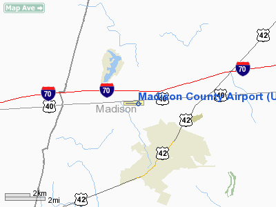
Madison County Airport (ICAO: KUYF, FAA LID: UYF) is a public airport located three miles (5 km) north of the central business district of London, a city in Madison County, Ohio, United States. It is owned by the Madison County Airport Authority.
Although most U.S. airports use the same three-letter location identifier for the FAA and IATA, Madison County Airport is assigned UYF by the FAA but has no designation from the IATA.
Facilities and aircraft
Madison County Airport covers an area of 148 acres (60 ha) which contains one runway designated 9/27 with a 4,001 x 75 ft (1,220 x 23 m) asphalt pavement. For the 12-month period ending April 20, 2007, the airport had 41,410 aircraft operations, an average of 113 per day: 95% general aviation, 5% military and <1% air taxi.
The above content comes from Wikipedia and is published under free licenses – click here to read more.
Location & QuickFacts
| FAA Information Effective: | 2008-09-25 |
| Airport Identifier: | UYF |
| Airport Status: | Operational |
| Longitude/Latitude: | 083-27-43.2000W/39-55-57.8000N
-83.462000/39.932722 (Estimated) |
| Elevation: | 1082 ft / 329.79 m (Surveyed) |
| Land: | 148 acres |
| From nearest city: | 3 nautical miles N of London, OH |
| Location: | Madison County, OH |
| Magnetic Variation: | 06W (2000) |
Owner & Manager
| Ownership: | Publicly owned |
| Owner: | Madison County Airport Auth |
| Address: | 1281 Us Rt 40 Sw
London, OH 43140 |
| Phone number: | 740-852-5040 |
| Manager: | James Musgrove |
| Address: | 1281 St Rt 40 Sw
London, OH 43140 |
| Phone number: | 740-852-5040 |
Airport Operations and Facilities
| Airport Use: | Open to public |
| Wind indicator: | Yes |
| Segmented Circle: | No |
| Control Tower: | No |
| Lighting Schedule: | DUSK-DAWN
ACTVT MIRL RY 09/27 & REIL & PAPI RYS 09 & 27 - CTAF. |
| Beacon Color: | Clear-Green (lighted land airport) |
| Landing fee charge: | No |
| Sectional chart: | Cincinnati |
| Region: | AGL - Great Lakes |
| Boundary ARTCC: | ZID - Indianapolis |
| Tie-in FSS: | DAY - Dayton |
| FSS on Airport: | No |
| FSS Toll Free: | 1-800-WX-BRIEF |
| NOTAMs Facility: | DAY (NOTAM-d service avaliable) |
| Federal Agreements: | NGY |
Airport Communications
| CTAF: | 123.000 |
| Unicom: | 123.000 |
Airport Services
| Fuel available: | 100LLA1+
FOR FUEL AFTER HRS CALL 740-852-9948. |
| Airframe Repair: | MAJOR |
| Power Plant Repair: | MAJOR |
| Bottled Oxygen: | NONE |
Runway Information
Runway 09/27
| Dimension: | 4001 x 75 ft / 1219.5 x 22.9 m |
| Surface: | ASPH, Good Condition |
| Weight Limit: | Single wheel: 30000 lbs.
Dual wheel: 40000 lbs. |
| Edge Lights: | Medium |
| |
Runway 09 |
Runway 27 |
| Longitude: | 083-28-08.8056W | 083-27-17.5417W |
| Latitude: | 39-55-56.6015N | 39-55-58.9289N |
| Elevation: | 1082.00 ft | 1051.00 ft |
| Alignment: | 87 | 127 |
| Traffic Pattern: | Left | Left |
| Markings: | Non-precision instrument, Good Condition | Non-precision instrument, Good Condition |
| Crossing Height: | 31.00 ft | 31.00 ft |
| VASI: | 4-light PAPI on left side | 4-light PAPI on left side |
| Runway End Identifier: | Yes | Yes |
| Centerline Lights: | No | No |
| Touchdown Lights: | No | No |
| Obstruction: | , 50:1 slope to clear | 53 ft trees, 1338.0 ft from runway, 388 ft right of centerline, 22:1 slope to clear |
|
Radio Navigation Aids
| ID |
Type |
Name |
Ch |
Freq |
Var |
Dist |
| UYF | NDB | London | | 263.00 | 06W | 0.2 nm |
| BU | NDB | Boutn | | 230.00 | 05W | 13.7 nm |
| OS | NDB | Fuler | | 515.00 | 05W | 14.8 nm |
| CCJ | NDB | Clark County | | 341.00 | 04W | 15.0 nm |
| MRT | NDB | Marysville | | 403.00 | 05W | 18.4 nm |
| DKG | NDB | Don Scott | | 348.00 | 05W | 19.7 nm |
| CSS | NDB | Court House | | 414.00 | 05W | 20.2 nm |
| CHC | NDB | Grens | | 272.00 | 04W | 20.5 nm |
| XEN | NDB | Xenia | | 395.00 | 03W | 25.2 nm |
| DLZ | NDB | Delaware | | 215.00 | 06W | 26.5 nm |
| IL | NDB | Airbo | | 407.00 | 04W | 29.4 nm |
| EDJ | NDB | Bellefontaine | | 242.00 | 05W | 30.9 nm |
| CM | NDB | Sumie | | 391.00 | 05W | 32.8 nm |
| RUV | NDB | Rushsylvania | | 326.00 | 05W | 33.0 nm |
| CYO | NDB | Circleville | | 366.00 | 05W | 33.2 nm |
| RZT | NDB | Ross County | | 236.00 | 05W | 35.8 nm |
| HW | NDB | Cubla | | 299.00 | 04W | 39.7 nm |
| MNN | NDB | Marion | | 201.00 | 05W | 44.9 nm |
| HOC | NDB | Hillsboro | | 278.00 | 05W | 45.1 nm |
| HEH | NDB | Newark | | 524.00 | 06W | 46.3 nm |
| XSF | TACAN | Springfield | 065X | | 04W | 18.4 nm |
| LCK | TACAN | Rickenbacker | 069X | | 05W | 25.7 nm |
| FFO | TACAN | Patterson | 099X | | 04W | 28.2 nm |
| XUB | VOR | Yellow Bud | | 112.50 | 05W | 33.1 nm |
| BUD | VOR | Buckeye | | 109.80 | 05W | 45.0 nm |
| SGH | VOR/DME | Springfield | 079X | 113.20 | 04W | 18.6 nm |
| MXQ | VOR/DME | Midwest | 076X | 112.90 | 04W | 34.1 nm |
| DQN | VOR/DME | Dayton | 092X | 114.50 | 01W | 43.4 nm |
| ROD | VORTAC | Rosewood | 122X | 117.50 | 05W | 34.2 nm |
| APE | VORTAC | Appleton | 114X | 116.70 | 06W | 42.3 nm |
| CMH | VOT | Port Columbus | | 111.00 | | 26.8 nm |
| DAY | VOT | Dayton J M Cox-day | | 111.00 | | 35.0 nm |
Remarks
Images and information placed above are from
http://www.airport-data.com/airport/UYF/
We thank them for the data!
| General Info
|
| Country |
United States
|
| State |
OHIO
|
| FAA ID |
UYF
|
| Latitude |
39-55-57.817N
|
| Longitude |
083-27-43.213W
|
| Elevation |
1081 feet
|
| Near City |
LONDON
|
We don't guarantee the information is fresh and accurate. The data may
be wrong or outdated.
For more up-to-date information please refer to other sources.
|
|


