|
|
Lorain County Rgnl Airport |
| Lorain County Regional Airport |
| IATA: LPR – ICAO: KLPR – FAA LID: LPR |
| Summary |
| Airport type |
Public |
| Owner |
Lorain County Board of Commissioners |
| Serves |
Lorain/Elyria, Ohio |
| Elevation AMSL |
793 ft / 242 m |
| Coordinates |
41°20′39.4″N 082°10′39.5″W / 41.344278°N 82.177639°W / 41.344278; -82.177639 |
| Runways |
| Direction |
Length |
Surface |
| ft |
m |
| 07/25 |
5,002 |
1,525 |
Asphalt |
| Statistics (2005) |
| Aircraft operations |
42,610 |
| Based aircraft |
89 |
| Source: Federal Aviation Administration |
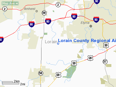
Lorain County Regional Airport is a public use airport in Lorain County, Ohio, United States. It is owned by the Lorain County Board of Commissioners and is located six nautical miles (11.11 km) south of the Lorain/Elyria metropolitan area. According to the FAA's National Plan of Integrated Airport Systems for 2007-2011, it is categorized as a reliever airport. Facilities and aircraft
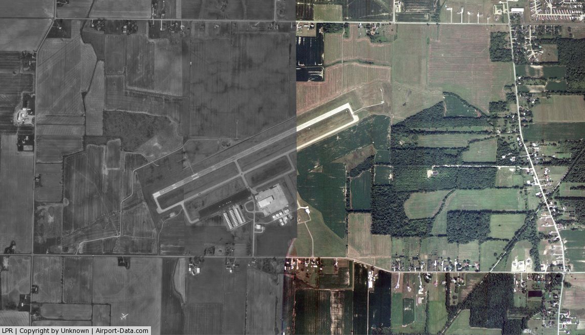
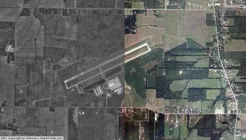
Lorain County Regional Airport covers an area of 1,149 acres (465 ha) at an elevation of 793 feet (242 m) above mean sea level. It has one runway designated 07/25 with a grooved asphalt surface measuring 5,002 by 100 feet (1,525 x 30 m).
For the 12-month period ending December 31, 2005, the airport had 42,610 aircraft operations, an average of 118 per day: 82% general aviation, 18% air taxi and a few military. At that time there were 89 aircraft based at this airport: 85% single-engine, 12% multi-engine and 3% jets.
Accidents and incidents
- On 18 January 2010, a Mitsubishi MU-2-2B-60 turboprop crashed on approach, killing three.
The above content comes from Wikipedia and is published under free licenses – click here to read more.
 |
(Click on the photo to enlarge) |
Location & QuickFacts
| FAA Information Effective: | 2008-09-25 |
| Airport Identifier: | LPR |
| Airport Status: | Operational |
| Longitude/Latitude: | 082-10-39.5000W/41-20-39.4000N
-82.177639/41.344278 (Estimated) |
| Elevation: | 793 ft / 241.71 m (Surveyed) |
| Land: | 1149 acres |
| From nearest city: | 6 nautical miles S of Lorain/elyria, OH |
| Location: | Lorain County, OH |
| Magnetic Variation: | 04W (1965) |
Owner & Manager
| Ownership: | Publicly owned |
| Owner: | Lorain Co Board Of Commissioners |
| Address: | 44050 Russia Rd
Elyria, OH 44035 |
| Phone number: | 440-323-4063 |
| Manager: | Doug Mcconnell |
| Address: | C/o Johnston Aviation, 44050 Russia Rd
Elyria, OH 44035 |
| Phone number: | 440-323-4063
OR 440-988-9137 |
Airport Operations and Facilities
| Airport Use: | Open to public |
| Wind indicator: | Yes |
| Segmented Circle: | Yes |
| Control Tower: | No |
| Lighting Schedule: | DUSK-DAWN
HIRL RY 07/25 PRESET LOW INTST; TO INCR INTST & ACTVT MALSR RY 07 - CTAF. |
| Beacon Color: | Clear-Green (lighted land airport) |
| Landing fee charge: | No |
| Sectional chart: | Detroit |
| Region: | AGL - Great Lakes |
| Traffic Pattern Alt: | 1000 ft |
| Boundary ARTCC: | ZOB - Cleveland |
| Tie-in FSS: | CLE - Cleveland |
| FSS on Airport: | No |
| FSS Toll Free: | 1-800-WX-BRIEF |
| NOTAMs Facility: | LPR (NOTAM-d service avaliable) |
| Federal Agreements: | NGY |
Airport Communications
| CTAF: | 122.700 |
| Unicom: | 122.700 |
Airport Services
| Fuel available: | 100LLA |
| Airframe Repair: | MAJOR |
| Power Plant Repair: | MAJOR |
| Bottled Oxygen: | NONE |
| Bulk Oxygen: | NONE |
Runway Information
Runway 07/25
| Dimension: | 5002 x 100 ft / 1524.6 x 30.5 m |
| Surface: | ASPH, Fair Condition |
| Surface Treatment: | Saw-cut or plastic Grooved |
| Weight Limit: | Single wheel: 80000 lbs.
Dual wheel: 110000 lbs.
Dual tandem wheel: 180000 lbs. |
| Edge Lights: | High |
| |
Runway 07 |
Runway 25 |
| Longitude: | 082-11-09.1740W | 082-10-09.7408W |
| Latitude: | 41-20-28.9569N | 41-20-49.8343N |
| Elevation: | 793.00 ft | 787.00 ft |
| Alignment: | 65 | 127 |
| ILS Type: | ILS
| |
| Traffic Pattern: | Left | Right |
| Markings: | Precision instrument, Good Condition | Non-precision instrument, Good Condition |
| Crossing Height: | 54.00 ft | 40.00 ft |
| VASI: | 4-light PAPI on left side | 4-light PAPI on left side |
| Visual Glide Angle: | 3.00° | 3.00° |
| Approach lights: | MALSR | |
| Runway End Identifier: | No | Yes |
| Obstruction: | , 50:1 slope to clear | 78 ft trees, 3500.0 ft from runway, 300 ft left of centerline, 42:1 slope to clear |
|
Radio Navigation Aids
| ID |
Type |
Name |
Ch |
Freq |
Var |
Dist |
| CL | NDB | Harri | | 344.00 | 07W | 9.6 nm |
| EZE | NDB | Engel | | 226.00 | 07W | 22.3 nm |
| AAU | NDB | Ashland | | 329.00 | 07W | 23.2 nm |
| BKL | NDB | Burke Lakefront | | 416.00 | 07W | 25.7 nm |
| PCW | NDB | Port Clinton | | 423.00 | 06W | 32.9 nm |
| PT | NDB | Pelee Island | | 283.00 | 05W | 34.3 nm |
| MF | NDB | Manns | | 372.00 | 06W | 36.8 nm |
| AK | NDB | Akron | | 362.00 | 07W | 39.4 nm |
| LQL | NDB | Lakeland | | 263.00 | 08W | 41.3 nm |
| TII | NDB | Tiffin | | 269.00 | 05W | 48.9 nm |
| DJB | VOR/DME | Dryer | 083X | 113.60 | 05W | 1.1 nm |
| SKY | VOR/DME | Sandusky | 029X | 109.20 | 04W | 22.2 nm |
| LNN | VOR/DME | Lost Nation | 039X | 110.20 | 08W | 40.9 nm |
| ACO | VOR/DME | Akron | 091X | 114.40 | 04W | 46.4 nm |
| CXR | VOR/DME | Chardon | 074X | 112.70 | 05W | 46.9 nm |
| BSV | VOR/DME | Briggs | 071X | 112.40 | 04W | 49.6 nm |
| MFD | VORTAC | Mansfield | 025X | 108.80 | 03W | 34.2 nm |
| CLE | VOT | Cleveland | | 110.40 | | 15.4 nm |
| CAK | VOT | Akron/canton Regional | | 110.60 | | 42.1 nm |
Remarks
- PILOTS OPERG IN OBERLIN AREA REQD TO AVOID & RMN WELL CLR OF OBERLIN COLLEGE DUE TO MUSIC CONSERVATORY; ALL TFC OPNS NORTH OF ARPT AS PER FAR PART 93 SUBPART J.
- BIRDS; COYOTES & DEER ON & INVOF ARPT.
Images and information placed above are from
http://www.airport-data.com/airport/LPR/
We thank them for the data!
| General Info
|
| Country |
United States
|
| State |
OHIO
|
| FAA ID |
LPR
|
| Latitude |
41-20-39.400N
|
| Longitude |
082-10-39.500W
|
| Elevation |
793 feet
|
| Near City |
LORAIN/ELYRIA
|
We don't guarantee the information is fresh and accurate. The data may
be wrong or outdated.
For more up-to-date information please refer to other sources.
|
|