 |
|
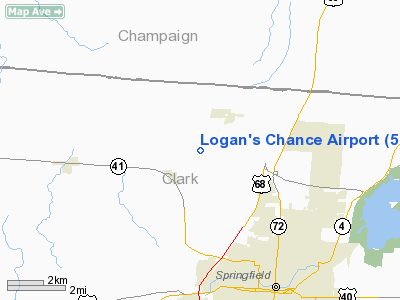
Location & QuickFacts
| FAA Information Effective: | 2008-09-25 |
| Airport Identifier: | 57OI |
| Airport Status: | Operational |
| Longitude/Latitude: | 083-51-16.7500W/39-59-48.2150N
-83.854653/39.996726 (Estimated) |
| Elevation: | 1100 ft / 335.28 m (Estimated) |
| Land: | 5 acres |
| From nearest city: | 1 nautical miles NW of Lawrenceville, OH |
| Location: | Clark County, OH |
| Magnetic Variation: | 04W (1980) |
Owner & Manager
| Ownership: | Privately owned |
| Owner: | Roy C. Madison |
| Address: | 4680 Hominy Ridge Rd
Springfield, OH 45502 |
| Phone number: | 513-969-8510 |
| Address: |
|
Airport Operations and Facilities
| Airport Use: | Private |
| Wind indicator: | Yes |
| Segmented Circle: | No |
| Control Tower: | No |
| Sectional chart: | Cincinnati |
| Region: | AGL - Great Lakes |
| Boundary ARTCC: | ZID - Indianapolis |
| Tie-in FSS: | DAY - Dayton |
| FSS Toll Free: | 1-800-WX-BRIEF |
Runway Information
Runway 09/27
| Dimension: | 1500 x 100 ft / 457.2 x 30.5 m |
| Surface: | TURF, |
| |
Runway 09 |
Runway 27 |
| Traffic Pattern: | Right | Left |
| Obstruction: | 30 ft pline, 300.0 ft from runway | |
|
Radio Navigation Aids
| ID |
Type |
Name |
Ch |
Freq |
Var |
Dist |
| CCJ | NDB | Clark County | | 341.00 | 04W | 8.2 nm |
| XEN | NDB | Xenia | | 395.00 | 03W | 17.3 nm |
| UYF | NDB | London | | 263.00 | 06W | 18.3 nm |
| EDJ | NDB | Bellefontaine | | 242.00 | 05W | 22.6 nm |
| MRT | NDB | Marysville | | 403.00 | 05W | 27.0 nm |
| RUV | NDB | Rushsylvania | | 326.00 | 05W | 29.1 nm |
| OS | NDB | Fuler | | 515.00 | 05W | 30.6 nm |
| IL | NDB | Airbo | | 407.00 | 04W | 30.8 nm |
| BU | NDB | Boutn | | 230.00 | 05W | 31.8 nm |
| CSS | NDB | Court House | | 414.00 | 05W | 32.0 nm |
| VES | NDB | Versailles | | 356.00 | 04W | 33.2 nm |
| DKG | NDB | Don Scott | | 348.00 | 05W | 36.1 nm |
| CHC | NDB | Grens | | 272.00 | 04W | 38.0 nm |
| DLZ | NDB | Delaware | | 215.00 | 06W | 38.4 nm |
| HW | NDB | Cubla | | 299.00 | 04W | 38.7 nm |
| HKF | NDB | Hook Field | | 239.00 | 04W | 40.6 nm |
| LYL | NDB | Lima | | 362.00 | 04W | 43.2 nm |
| CQA | NDB | Lakefield | | 205.00 | 04W | 43.7 nm |
| CYO | NDB | Circleville | | 366.00 | 05W | 49.4 nm |
| XSF | TACAN | Springfield | 065X | | 04W | 9.6 nm |
| FFO | TACAN | Patterson | 099X | | 04W | 14.1 nm |
| LCK | TACAN | Rickenbacker | 069X | | 05W | 44.2 nm |
| AOH | VOR | Allen County | | 108.40 | 04W | 43.0 nm |
| XUB | VOR | Yellow Bud | | 112.50 | 05W | 49.4 nm |
| SGH | VOR/DME | Springfield | 079X | 113.20 | 04W | 9.6 nm |
| DQN | VOR/DME | Dayton | 092X | 114.50 | 01W | 25.0 nm |
| MXQ | VOR/DME | Midwest | 076X | 112.90 | 04W | 34.2 nm |
| ROD | VORTAC | Rosewood | 122X | 117.50 | 05W | 19.5 nm |
| RID | VORTAC | Richmond | 043X | 110.60 | 03W | 47.7 nm |
| DAY | VOT | Dayton J M Cox-day | | 111.00 | | 17.8 nm |
| CMH | VOT | Port Columbus | | 111.00 | | 44.6 nm |
Remarks
- PRVDD TRAFFIC PATTERNS ARE S OF RY 09/27; OBSTRUCTIONS REMOVED/LOWERED OR THR DSPLCD TO PROVIDE 20:1 APCH CLEARANCE.
Images and information placed above are from
http://www.airport-data.com/airport/57OI/
We thank them for the data!
| General Info
|
| Country |
United States
|
| State |
OHIO
|
| FAA ID |
57OI
|
| Latitude |
39-59-48.215N
|
| Longitude |
083-51-16.750W
|
| Elevation |
1100 feet
|
| Near City |
LAWRENCEVILLE
|
We don't guarantee the information is fresh and accurate. The data may
be wrong or outdated.
For more up-to-date information please refer to other sources.
|
|


