|
|
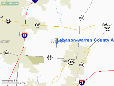
Lebanon-warren County Airport |
Coordinates: 39°27′44″N 084°15′07″W / 39.46222°N 84.25194°W / 39.46222; -84.25194
| Lebanon-Warren County Airport |
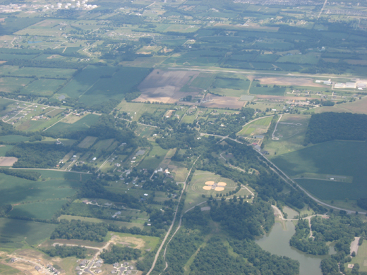 |
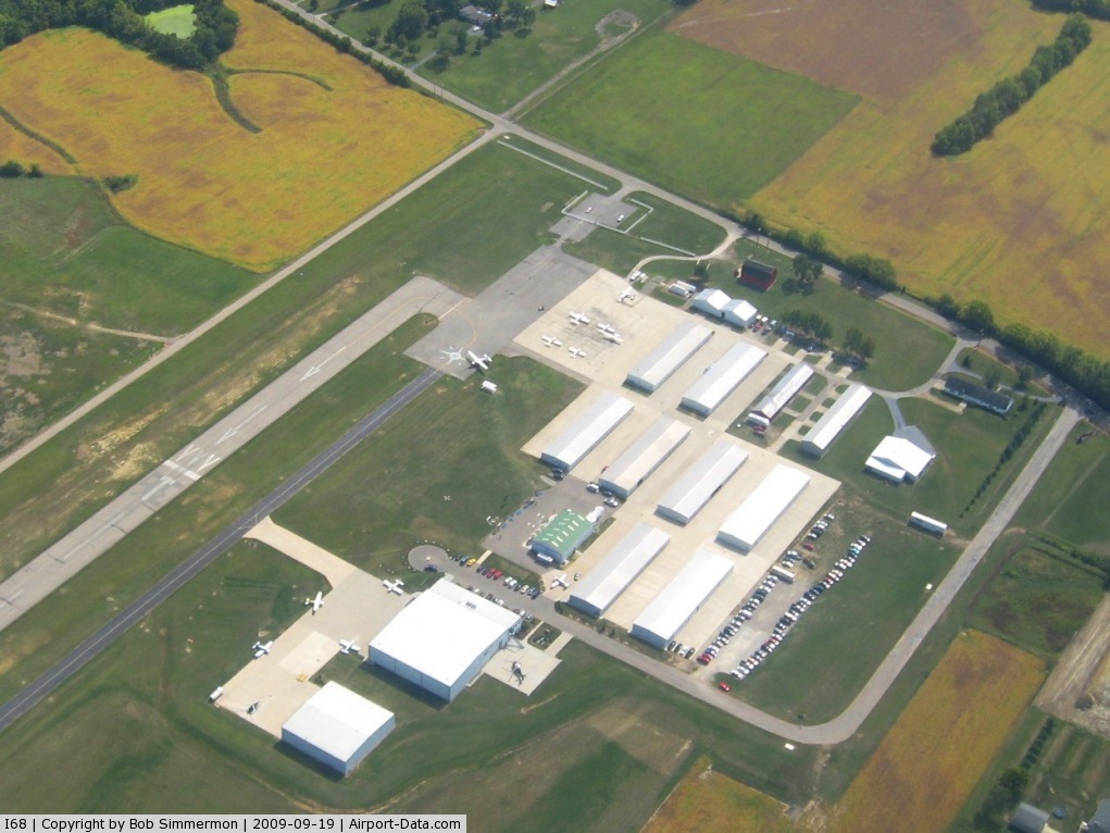
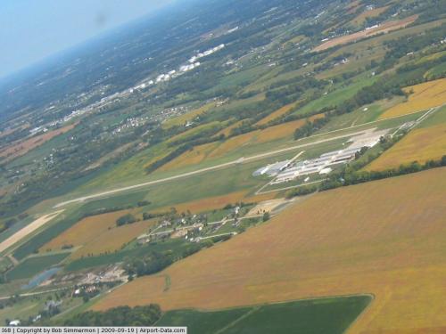
| The Lebanon-Warren County Airport and surrounding countryside, seen from the west |
| IATA: none – ICAO: none – FAA LID: I68 |
| Summary |
| Airport type |
Public |
| Owner |
Warren County Airport Authority |
| Operator |
Warren County Airport, Ltd. |
| Serves |
Warren County, Ohio |
| Location |
Lebanon, Ohio |
| Elevation AMSL |
898 ft / 274 m |
| Runways |
| Direction |
Length |
Surface |
| ft |
m |
| 1/19 |
4,502 |
1,372 |
Asphalt |
| Statistics (2006) |
| Aircraft operations |
24,951 |
| Based aircraft |
104 |
| Source: Federal Aviation Administration |
Lebanon-Warren County Airport (FAA LID: I68) is a public airport located three miles (5 km) northwest of the central business district of Lebanon, on Greentree Road, in Warren County, Ohio, United States.
It is a county owned public airport operated by the Warren County Airport Authority, a board of 9 members appointed by the County Commissioners. The runway, taxiway, and Communication and Navigation aids are County owned. The Airport Authority leases a terminal for public use on adjacent private property. The hangars, and other airport buildings are privately owned and operated. Daily airport management is handled under contract by fixed base operator (FBO), Warren County Airport, Ltd. Facilities
Runway
There is one North-South Runway (01/19). The runway is 4203' x 65' asphalt paved with lighting for night operation. The runway has displaced thresholds on both ends to clear obstructions. Airport elevation is 898'. There is a taxiway parallel to the runway.
Navigation and Communications aids
- MIRL Runway & Taxiway lights
- PCL Pilot Controlled Lighting - Frequency 123.075
- REIL - Runway End Identification Lights
- Rotating beacon - White-Green
- Wind sock near center of runway, between runway and taxiway
- Segmented Circle - Near Windsock
- Tower with obstruction light mid-field east of runway
- 4 light PAPI
- AWOS Automated Weather Observation System - Frequency 120.550, By Phone 513-934-5500
- Unicom - Frequency 123.075
- Online weather information service in terminal building
Privately operated airport services
- Aviation Fuel
- Hangar Rental
- Pilot training
- Aircraft Rental
- Aircraft Charters
- Warren County Career Center - Aerospace Academy
- Miami Valley Hospital Careflight helicopter base and helipad
- Home of a Wright Flyer replica built for the 100th anniversary of aviation held in 2003
- Skydiving
- Helicopter Training, rides, photo flights, and other helicopter services
- Hot air ballooning
Aircraft
For the 12-month period ending December 19, 2006, the airport had 24,951 aircraft operations, an average of 68 per day: 99% general aviation, 1% air taxi and <1% military. There are 104 aircraft based at this airport: 72% single-engine, 26% multi-engine (27) and 2% jet.
The above content comes from Wikipedia and is published under free licenses – click here to read more.
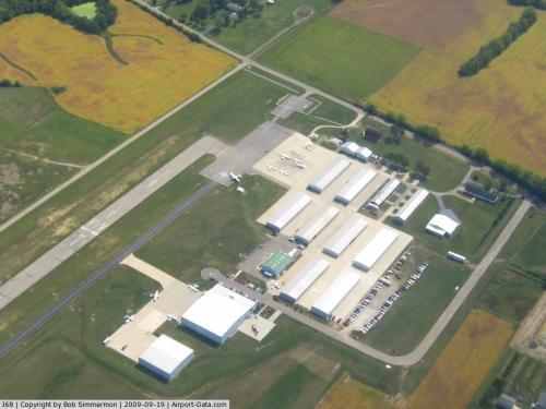 |
(Click on the photo to enlarge) |
 |
(Click on the photo to enlarge) |
Location & QuickFacts
| FAA Information Effective: | 2008-09-25 |
| Airport Identifier: | I68 |
| Airport Status: | Operational |
| Longitude/Latitude: | 084-15-06.6497W/39-27-43.8230N
-84.251847/39.462173 (Estimated) |
| Elevation: | 898 ft / 273.71 m (Surveyed) |
| Land: | 120 acres |
| From nearest city: | 3 nautical miles NW of Lebanon, OH |
| Location: | Warren County, OH |
| Magnetic Variation: | 05W (2000) |
Owner & Manager
| Ownership: | Publicly owned |
| Owner: | Warren County Airport, Ltd |
| Address: | 2460 Greentree Rd
Lebanon, OH 45036 |
| Phone number: | 513-932-7966 |
| Manager: | Brian Carr |
| Address: | 2460 Greentree Rd
Lebanon, OH 45036 |
| Phone number: | 513-932-7966 |
Airport Operations and Facilities
| Airport Use: | Open to public |
| Wind indicator: | Yes |
| Segmented Circle: | Yes |
| Control Tower: | No |
| Lighting Schedule: | DUSK-DAWN
ACTVT MIRL RY 01/19 - 123.075 |
| Beacon Color: | Clear-Green (lighted land airport) |
| Landing fee charge: | No |
| Sectional chart: | Cincinnati |
| Region: | AGL - Great Lakes |
| Boundary ARTCC: | ZID - Indianapolis |
| Tie-in FSS: | DAY - Dayton |
| FSS on Airport: | No |
| FSS Toll Free: | 1-800-WX-BRIEF |
| NOTAMs Facility: | DAY (NOTAM-d service avaliable) |
| Federal Agreements: | N |
Airport Communications
| CTAF: | 123.075 |
| Unicom: | 123.075 |
Airport Services
| Fuel available: | 100LLA |
| Airframe Repair: | MAJOR |
| Power Plant Repair: | MAJOR |
| Bottled Oxygen: | NONE |
| Bulk Oxygen: | HIGH |
Runway Information
Runway 01/19
| Dimension: | 4502 x 65 ft / 1372.2 x 19.8 m |
| Surface: | ASPH, Good Condition |
| Edge Lights: | Medium
NSTD MIRL RY 01/19, NOT LCTD AT CORRECT PLACE ADJ TO DSPLCD THLD MARKINGS. |
| |
Runway 01 |
Runway 19 |
| Longitude: | 084-15-08.7419W | 084-15-04.5571W |
| Latitude: | 39-27-21.6359N | 39-28-06.0100N |
| Elevation: | 883.00 ft | 898.00 ft |
| Alignment: | 4 | 127 |
| Traffic Pattern: | Right | Left |
| Markings: | Non-precision instrument, Good Condition | Non-precision instrument, Good Condition |
| Displaced threshold: | 630.00 ft
DSPLCD THLD NOT LGTD. | 410.00 ft
DSPLCD THLD AT THE 630 FT MARK IN NOT LGTD. THE FORMER DSPLCD THLD AT THE 363 FT MARK IS LGTD FOR NIGHT OPNS. |
| VASI: | 4-light PAPI on right side | 4-light PAPI on left side
RY 19 PAPI OTS INDEFLY. |
| Runway End Identifier: | Yes
REIL OTS INDEFLY. | Yes |
| Obstruction: | 12 ft road, 201.0 ft from runway, 201 ft right of centerline
APCH RATIO TO DSPLCD THLD 0:1 DUE TO +70 FT TREE; 201 FT FROM DSPLCD THLD; 345 FT R.
+12 FT ROAD; 0 TO 200 FT FROM END OF RY; 200 FT R; AIRCRAFT PARKING APRON 0 FT TO 200 FT FROM RY END; 70 - 250 FT L. | 41 ft trees, 305.0 ft from runway, 130 ft left of centerline, 2:1 slope to clear
RWY 19 APCH RATIO TO DSPLCD THLD 0:1 DUE TO +52 FT TREES; 201 FT FROM DSPLCD THLD; 362 FT L.
+0-6FT BRUSH 0-200FT FM,100-250FT LT |
|
Radio Navigation Aids
| ID |
Type |
Name |
Ch |
Freq |
Var |
Dist |
| HKF | NDB | Hook Field | | 239.00 | 04W | 9.3 nm |
| ISZ | NDB | Cincinnati-blue Ash | | 388.00 | 04W | 14.3 nm |
| MDE | NDB | Madeira | | 379.00 | 04W | 15.2 nm |
| HAO | NDB | Hamilton | | 260.00 | 04W | 15.8 nm |
| HW | NDB | Cubla | | 299.00 | 04W | 18.6 nm |
| LUK | NDB | Cincinnati | | 335.00 | 04W | 18.7 nm |
| XEN | NDB | Xenia | | 395.00 | 03W | 21.3 nm |
| PWF | NDB | Sportys | | 245.00 | 04W | 23.2 nm |
| IL | NDB | Airbo | | 407.00 | 04W | 24.0 nm |
| OXD | NDB | Oxford | | 282.00 | 04W | 24.7 nm |
| CCJ | NDB | Clark County | | 341.00 | 04W | 33.0 nm |
| UR | NDB | Burln | | 321.00 | 04W | 34.9 nm |
| HOC | NDB | Hillsboro | | 278.00 | 05W | 36.9 nm |
| CSS | NDB | Court House | | 414.00 | 05W | 40.7 nm |
| UYF | NDB | London | | 263.00 | 06W | 46.1 nm |
| VES | NDB | Versailles | | 356.00 | 04W | 46.4 nm |
| HLB | NDB | Batesville | | 254.00 | 02W | 47.2 nm |
| AMT | NDB | West Union | | 359.00 | 04W | 48.5 nm |
| FFO | TACAN | Patterson | 099X | | 04W | 23.3 nm |
| XSF | TACAN | Springfield | 065X | | 04W | 29.5 nm |
| MXQ | VOR/DME | Midwest | 076X | 112.90 | 04W | 21.0 nm |
| SGH | VOR/DME | Springfield | 079X | 113.20 | 04W | 29.3 nm |
| DQN | VOR/DME | Dayton | 092X | 114.50 | 01W | 34.0 nm |
| FLM | VOR/DME | Falmouth | 117X | 117.00 | 04W | 48.9 nm |
| RID | VORTAC | Richmond | 043X | 110.60 | 03W | 32.4 nm |
| CVG | VORTAC | Cincinnati | 120X | 117.30 | 04W | 34.1 nm |
| LUK | VOT | Cincinnati Muni/lunken | | 108.40 | | 21.9 nm |
| DAY | VOT | Dayton J M Cox-day | | 111.00 | | 26.5 nm |
Remarks
- PAEW ADJ RY & TWY INDEFLY.
- VFR OPNS ONLY
Images and information placed above are from
http://www.airport-data.com/airport/I68/
We thank them for the data!
| General Info
|
| Country |
United States
|
| State |
OHIO
|
| FAA ID |
I68
|
| Latitude |
39-27-43.823N
|
| Longitude |
084-15-06.650W
|
| Elevation |
898 feet
|
| Near City |
LEBANON
|
We don't guarantee the information is fresh and accurate. The data may
be wrong or outdated.
For more up-to-date information please refer to other sources.
|
|