 |
|
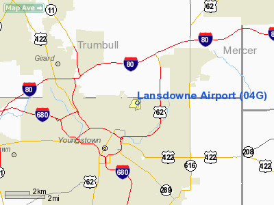
| Lansdowne Airport |
| IATA: none – ICAO: none – FAA LID: 04G |
| Summary |
| Airport type |
Public |
| Operator |
Lansdowne Land Associates |
| Location |
Youngstown, Ohio |
| Elevation AMSL |
1,044 ft / 318 m |
| Coordinates |
41°07′50″N 080°37′11″W / 41.13056°N 80.61972°W / 41.13056; -80.61972Coordinates: 41°07′50″N 080°37′11″W / 41.13056°N 80.61972°W / 41.13056; -80.61972 |
| Runways |
| Direction |
Length |
Surface |
| ft |
m |
| 2/20 |
3,073 |
937 |
Asphalt |
Lansdowne Airport (FAA LID: 04G) is a small, local airport on the East Side of Youngstown, Ohio, US near the Pennsylvania border. Lansdowne Airport is a privately owned airport, located in an area known as the "Sharon Line" to locals, due to its proximity to a defunct train line that once ran from Youngstown to Sharon, right across the state line through the Steel Valleys.
Lansdowne Airport was the first airport in Youngstown and was the first in the region to see airmail service. The airport was dedicated as Lansdowne Field in late October, 1926 with Rear Admiral William A. Moffett in attendance. Because of the increasing size in airplanes and the lack of a suitable amount of land in the vicinity of Lansdowne, a decision was made to build Youngstown Municipal Airport eleven miles away in Vienna Center, Ohio.
While Lansdowne is listed as a public airport, it has been closed due to lack of maintenance.
The above content comes from Wikipedia and is published under free licenses – click here to read more.
Location & QuickFacts
| FAA Information Effective: | 2008-09-25 |
| Airport Identifier: | 04G |
| Airport Status: | Operational |
| Longitude/Latitude: | 080-37-10.5000W/41-07-49.7000N
-80.619583/41.130472 (Estimated) |
| Elevation: | 1044 ft / 318.21 m (Surveyed) |
| Land: | 112 acres |
| From nearest city: | 2 nautical miles NE of Youngstown, OH |
| Location: | Mahoning County, OH |
| Magnetic Variation: | 08W (1995) |
Owner & Manager
| Ownership: | Privately owned |
| Owner: | Boardman Steel, Inc. |
| Address: | P.o. Box 3425
Youngstown, OH 44513 |
| Phone number: | 330-534-3580 |
| Manager: | Art Toby |
| Address: | 205 Charles Street
Youngstown, OH 44425 |
| Phone number: | 330-534-3580
ADDITIONAL NR 330-744-0288. |
Airport Operations and Facilities
| Airport Use: | Open to public |
| Wind indicator: | Yes |
| Segmented Circle: | No |
| Control Tower: | No |
| Landing fee charge: | No |
| Sectional chart: | Detroit |
| Region: | AGL - Great Lakes |
| Boundary ARTCC: | ZOB - Cleveland |
| Tie-in FSS: | CLE - Cleveland |
| FSS on Airport: | No |
| FSS Toll Free: | 1-800-WX-BRIEF
OR LOCAL CALL 539-5121. |
| NOTAMs Facility: | CLE (NOTAM-d service avaliable) |
Airport Communications
| CTAF: | 122.800 |
| Unicom: | 122.800 |
Airport Services
Runway Information
Runway 02/20
| Dimension: | 3073 x 50 ft / 936.7 x 15.2 m |
| Surface: | ASPH, Fair Condition
VEGETATION IN CRACKS, LAST 500 FT RY 12 DEPRESSIONS IN PAVEMENT. |
| Weight Limit: | Single wheel: 7500 lbs. |
| |
Runway 02 |
Runway 20 |
| Longitude: | 080-37-15.8637W | 080-37-05.1154W |
| Latitude: | 41-07-35.0903N | 41-08-04.3446N |
| Elevation: | 1015.00 ft | 1044.00 ft |
| Alignment: | 16 | 127 |
| Traffic Pattern: | Left | Left |
| Runway End Identifier: | No | No |
| Centerline Lights: | No | No |
| Touchdown Lights: | No | No |
| Obstruction: | 60 ft trees, 201.0 ft from runway, 110 ft left of centerline
RWY 02 +20-60 FT TREES 110-200 FT FM RY END 65-125 FT L; +6' DUMP AREA 135' TO 200' FM 65'L TO 125'R. | 36 ft trees, 201.0 ft from runway, 100 ft right of centerline
+15 FT RD 72 FT FM THLD; +49 FT TREES 0-200 FT FM RY END 75-125 FT R; +4 FT KNOLL 40 FT FM RY END 0-125 FT L&R; +5 FT TO +22 FT TREES/BRUSH 50 FT FM 0-125 FT L&R. |
|
Radio Navigation Aids
| ID |
Type |
Name |
Ch |
Freq |
Var |
Dist |
| HBD | NDB | Hubbard | | 408.00 | 08W | 4.2 nm |
| UCP | NDB | Castle | | 272.00 | 09W | 11.3 nm |
| AK | NDB | Akron | | 362.00 | 07W | 35.0 nm |
| TSO | NDB | Tolson | | 395.00 | 07W | 40.0 nm |
| LQL | NDB | Lakeland | | 263.00 | 08W | 47.7 nm |
| FKL | VOR | Franklin | | 109.60 | 06W | 39.1 nm |
| ACO | VOR/DME | Akron | 091X | 114.40 | 04W | 26.4 nm |
| CXR | VOR/DME | Chardon | 074X | 112.70 | 05W | 33.8 nm |
| JFN | VOR/DME | Jefferson | 099X | 115.20 | 05W | 38.3 nm |
| BSV | VOR/DME | Briggs | 071X | 112.40 | 04W | 43.7 nm |
| LNN | VOR/DME | Lost Nation | 039X | 110.20 | 08W | 48.1 nm |
| YNG | VORTAC | Youngstown | 027X | 109.00 | 05W | 12.3 nm |
| EWC | VORTAC | Ellwood City | 105X | 115.80 | 08W | 26.1 nm |
| MMJ | VORTAC | Montour | 057X | 112.00 | 08W | 43.2 nm |
| CAK | VOT | Akron/canton Regional | | 110.60 | | 39.5 nm |
Remarks
- RAMP IN POOR CONDITION; BREAKING PAVEMENT.
Images and information placed above are from
http://www.airport-data.com/airport/04G/
We thank them for the data!
| General Info
|
| Country |
United States
|
| State |
OHIO
|
| FAA ID |
04G
|
| Latitude |
41-07-49.700N
|
| Longitude |
080-37-10.500W
|
| Elevation |
1044 feet
|
| Near City |
YOUNGSTOWN
|
We don't guarantee the information is fresh and accurate. The data may
be wrong or outdated.
For more up-to-date information please refer to other sources.
|
|


