 |
|
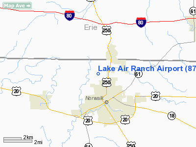
Location & QuickFacts
| FAA Information Effective: | 2008-09-25 |
| Airport Identifier: | 87OI |
| Airport Status: | Operational |
| Longitude/Latitude: | 082-37-22.6400W/41-16-20.1890N
-82.622956/41.272275 (Estimated) |
| Elevation: | 690 ft / 210.31 m (Estimated) |
| Land: | 15 acres |
| From nearest city: | 4 nautical miles NW of Norwalk, OH |
| Location: | Huron County, OH |
| Magnetic Variation: | 05W (1985) |
Owner & Manager
| Ownership: | Privately owned |
| Owner: | Alden V. & Daniel J. Lake |
| Address: | 857 Lais Road
Norwalk, OH 44857 |
| Phone number: | 419-663-5253 |
| Manager: | Dan Lake |
| Address: | 854 Lais Road
Norwalk, OH 44857 |
| Phone number: | 419-668-4340 |
Airport Operations and Facilities
| Airport Use: | Private |
| Wind indicator: | Yes |
| Segmented Circle: | No |
| Control Tower: | No |
| Sectional chart: | Detroit |
| Region: | AGL - Great Lakes |
| Boundary ARTCC: | ZOB - Cleveland |
| Tie-in FSS: | CLE - Cleveland |
| FSS Toll Free: | 1-800-WX-BRIEF |
Runway Information
Runway 01/19
| Dimension: | 2100 x 80 ft / 640.1 x 24.4 m |
| Surface: | TURF, |
| |
Runway 01 |
Runway 19 |
| Traffic Pattern: | Left | Left |
| Obstruction: | 50 ft trees, 300.0 ft from runway | 50 ft trees, 300.0 ft from runway |
|
Radio Navigation Aids
| ID |
Type |
Name |
Ch |
Freq |
Var |
Dist |
| PCW | NDB | Port Clinton | | 423.00 | 06W | 18.5 nm |
| AAU | NDB | Ashland | | 329.00 | 07W | 25.0 nm |
| TII | NDB | Tiffin | | 269.00 | 05W | 28.4 nm |
| CL | NDB | Harri | | 344.00 | 07W | 30.0 nm |
| PT | NDB | Pelee Island | | 283.00 | 05W | 30.6 nm |
| MF | NDB | Manns | | 372.00 | 06W | 31.5 nm |
| FZI | NDB | Fostoria | | 379.00 | 05W | 35.3 nm |
| EZE | NDB | Engel | | 226.00 | 07W | 42.6 nm |
| MNN | NDB | Marion | | 201.00 | 05W | 44.3 nm |
| BKL | NDB | Burke Lakefront | | 416.00 | 07W | 45.9 nm |
| BNR | NDB | Benton Ridge | | 334.00 | 05W | 49.7 nm |
| BUD | VOR | Buckeye | | 109.80 | 05W | 44.2 nm |
| MAH | VOR | Marathon | | 114.90 | 05W | 49.6 nm |
| SKY | VOR/DME | Sandusky | 029X | 109.20 | 04W | 9.9 nm |
| DJB | VOR/DME | Dryer | 083X | 113.60 | 05W | 21.4 nm |
| VWV | VOR/DME | Waterville | 078X | 113.10 | 02W | 47.1 nm |
| MFD | VORTAC | Mansfield | 025X | 108.80 | 03W | 24.3 nm |
| CLE | VOT | Cleveland | | 110.40 | | 35.9 nm |
Remarks
Images and information placed above are from
http://www.airport-data.com/airport/87OI/
We thank them for the data!
| General Info
|
| Country |
United States
|
| State |
OHIO
|
| FAA ID |
87OI
|
| Latitude |
41-16-20.189N
|
| Longitude |
082-37-22.640W
|
| Elevation |
690 feet
|
| Near City |
NORWALK
|
We don't guarantee the information is fresh and accurate. The data may
be wrong or outdated.
For more up-to-date information please refer to other sources.
|
|


