 |
|
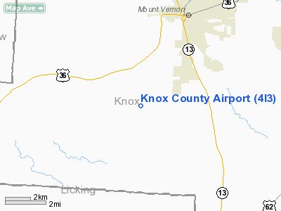
| Knox County Airport |
| IATA: none – ICAO: none – FAA LID: 4I3 |
| Summary |
| Airport type |
Public |
| Owner |
Knox County Airport Authority |
| Serves |
Mount Vernon, Ohio |
| Elevation AMSL |
1,191 ft / 363 m |
| Coordinates |
40°19′44″N 082°31′34″W / 40.32889°N 82.52611°W / 40.32889; -82.52611 |
| Runways |
| Direction |
Length |
Surface |
| ft |
m |
| 10/28 |
5,500 |
1,676 |
Asphalt |
| Statistics (2007) |
| Aircraft operations |
20,150 |
| Based aircraft |
52 |
| Source: Federal Aviation Administration |
Knox County Airport (FAA LID: 4I3) is a public use airport located four nautical miles (7 km) southwest of the central business district of Mount Vernon, a city in Knox County, Ohio, United States. It is owned by Knox County Airport Authority.
Facilities and aircraft
Knox County Airport covers an area of 280 acres (113 ha) at an elevation of 1,191 feet (363 m) above mean sea level. It has one runway designated 10/28 with a 5,500 x 100 ft (1,676 x 30 m) asphalt pavement.
For the 12-month period ending May 9, 2007, the airport had 20,150 aircraft operations, an average of 55 per day: 97% general aviation, 2% air taxi and <1% military. At that time there were 52 aircraft based at this airport: 92% single-engine, 4% multi-engine and 4% ultralight.
The above content comes from Wikipedia and is published under free licenses – click here to read more.
Location & QuickFacts
| FAA Information Effective: | 2008-09-25 |
| Airport Identifier: | 4I3 |
| Airport Status: | Operational |
| Longitude/Latitude: | 082-31-33.9000W/40-19-44.1000N
-82.526083/40.328917 (Estimated) |
| Elevation: | 1191 ft / 363.02 m (Surveyed) |
| Land: | 280 acres |
| From nearest city: | 4 nautical miles SW of Mount Vernon, OH |
| Location: | Knox County, OH |
| Magnetic Variation: | 06W (1990) |
Owner & Manager
| Ownership: | Publicly owned |
| Owner: | Knox Co Arpt Authority |
| Address: | 6481 Kinney Road
Mount Vernon, OH 43050 |
| Phone number: | 740-397-9647 |
| Manager: | Marla Elliott |
| Address: | 6481 Kinney Road
Mount Vernon, OH 43050 |
| Phone number: | 740-397-9647 |
Airport Operations and Facilities
| Airport Use: | Open to public |
| Wind indicator: | Yes |
| Segmented Circle: | No |
| Control Tower: | No |
| Lighting Schedule: | DUSK-DAWN
ACTVT MIRL RY 10/28 - CTAF. VASI RY 10 & PAPI RY 28 OPER CONTINOUSLY. |
| Beacon Color: | Clear-Green (lighted land airport) |
| Landing fee charge: | No |
| Sectional chart: | Detroit |
| Region: | AGL - Great Lakes |
| Traffic Pattern Alt: | 808 ft |
| Boundary ARTCC: | ZID - Indianapolis |
| Tie-in FSS: | CLE - Cleveland |
| FSS on Airport: | No |
| FSS Toll Free: | 1-800-WX-BRIEF |
| NOTAMs Facility: | CLE (NOTAM-d service avaliable) |
| Federal Agreements: | NY1 |
Airport Communications
| CTAF: | 123.050 |
| Unicom: | 123.050 |
Airport Services
| Fuel available: | 100LLA1+ |
| Airframe Repair: | MAJOR |
| Power Plant Repair: | MAJOR |
| Bottled Oxygen: | NONE |
| Bulk Oxygen: | NONE |
Runway Information
Runway 10/28
| Dimension: | 5500 x 100 ft / 1676.4 x 30.5 m |
| Surface: | ASPH, Fair Condition |
| Weight Limit: | Single wheel: 18000 lbs.
Dual wheel: 23000 lbs. |
| Edge Lights: | Medium |
| |
Runway 10 |
Runway 28 |
| Longitude: | 082-32-09.0700W | 082-30-58.7000W |
| Latitude: | 40-19-47.7200N | 40-19-40.4500N |
| Elevation: | 1187.00 ft | 1184.00 ft |
| Alignment: | 98 | 127 |
| Traffic Pattern: | Left | Left |
| Markings: | Non-precision instrument, Fair Condition | Non-precision instrument, Fair Condition |
| Crossing Height: | 40.00 ft | 40.00 ft |
| VASI: | 4-light PAPI on right side | 4-light PAPI on right side |
| Visual Glide Angle: | 3.00° | 3.00° |
| Runway End Identifier: | Yes | No |
| Centerline Lights: | No | No |
| Touchdown Lights: | No | No |
| Obstruction: | 116 ft tree, 3071.0 ft from runway, 544 ft right of centerline, 24:1 slope to clear | 40 ft trees, 1923.0 ft from runway, 383 ft left of centerline, 43:1 slope to clear |
|
Radio Navigation Aids
| ID |
Type |
Name |
Ch |
Freq |
Var |
Dist |
| HEH | NDB | Newark | | 524.00 | 06W | 18.4 nm |
| CM | NDB | Sumie | | 391.00 | 05W | 23.1 nm |
| MF | NDB | Manns | | 372.00 | 06W | 26.5 nm |
| DLZ | NDB | Delaware | | 215.00 | 06W | 26.6 nm |
| DKG | NDB | Don Scott | | 348.00 | 05W | 29.4 nm |
| CHC | NDB | Grens | | 272.00 | 04W | 30.0 nm |
| MNN | NDB | Marion | | 201.00 | 05W | 30.3 nm |
| MLR | NDB | Millersburg/dcmsnd | | 382.00 | 06W | 32.5 nm |
| OS | NDB | Fuler | | 515.00 | 05W | 34.5 nm |
| HRA | NDB | Zanesville | | 204.00 | 06W | 37.7 nm |
| MRT | NDB | Marysville | | 403.00 | 05W | 38.3 nm |
| AAU | NDB | Ashland | | 329.00 | 07W | 40.1 nm |
| BU | NDB | Boutn | | 230.00 | 05W | 43.7 nm |
| UYF | NDB | London | | 263.00 | 06W | 49.3 nm |
| LCK | TACAN | Rickenbacker | 069X | | 05W | 36.4 nm |
| BUD | VOR | Buckeye | | 109.80 | 05W | 30.1 nm |
| TVT | VOR/DME | Tiverton | 112X | 116.50 | 03W | 19.9 nm |
| ZZV | VOR/DME | Zanesville | 051X | 111.40 | 06W | 37.3 nm |
| CTW | VOR/DME | Newcomerstown | 055X | 111.80 | 07W | 48.5 nm |
| APE | VORTAC | Appleton | 114X | 116.70 | 06W | 11.1 nm |
| MFD | VORTAC | Mansfield | 025X | 108.80 | 03W | 32.6 nm |
| CMH | VOT | Port Columbus | | 111.00 | | 26.0 nm |
Remarks
Images and information placed above are from
http://www.airport-data.com/airport/4I3/
We thank them for the data!
| General Info
|
| Country |
United States
|
| State |
OHIO
|
| FAA ID |
4I3
|
| Latitude |
40-19-43.400N
|
| Longitude |
082-31-25.600W
|
| Elevation |
1192 feet
|
| Near City |
MOUNT VERNON
|
We don't guarantee the information is fresh and accurate. The data may
be wrong or outdated.
For more up-to-date information please refer to other sources.
|
|


