|
|
Coordinates: 41°09′05″N 081°24′54″W / 41.15139°N 81.415°W / 41.15139; -81.415
| Kent State University Airport |
 |
| IATA: none – ICAO: none – FAA LID: 1G3 |
| Summary |
| Airport type |
Public |
| Owner |
Kent State University |
| Serves |
Kent, Ohio |
| Location |
Stow, Ohio |
| Elevation AMSL |
1,150 ft / 351 m |
| Runways |
| Direction |
Length |
Surface |
| ft |
m |
| 1/19 |
4,000 |
1,219 |
Asphalt |
| 5/23 |
2,400 |
732 |
Turf |
| 9/27 |
1,170 |
357 |
Turf |
| Statistics (2005) |
| Aircraft operations |
72,500 |
| Based aircraft |
50 |
| Sources: FAA, airport website |
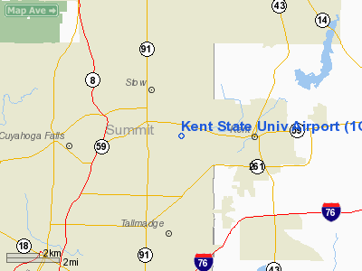
Kent State University Airport (FAA LID: 1G3) is a public airport in Stow, Ohio, United States owned by Kent State University. The airport is located along State Route 59 (Kent Road) approximately three miles (5 km) west of the central business district of Kent.
Besides being a public airport, the Kent State University Airport is used in the College of Technology's Aeronautics program which provides flight training and other professional aeronautical training to enrolled Kent State University students. The airport also operates a Flight Clinic for the general public who are interested in attaining private pilot instruction. Kent State has a leading Pilot Training Bridge Program with Continental Express designed to help highly-skilled and qualified students migrate as a pilot into the airline industry. Facilities and aircraft
Kent State University Airport covers an area of 298 acres (121 ha) which contains three runways:
- Runway 1/19: 4,000 x 60 ft (1,219 x 18 m), Surface: Asphalt
- Runway 5/23: 2,400 x 165 ft (732 x 50 m), Surface: Turf (Closed)
- Runway 9/27: 1,170 x 55 ft (357 x 17 m), Surface: Turf (Closed)
For the 12-month period ending November 8, 2005, the airport had 72,500 aircraft operations, an average of 198 per day: 97% general aviation, 2% air taxi and <1% military. There are 50 aircraft based at this airport: 96% single-engine and 4% multi-engine.
The above content comes from Wikipedia and is published under free licenses – click here to read more.
Location & QuickFacts
| FAA Information Effective: | 2008-09-25 |
| Airport Identifier: | 1G3 |
| Airport Status: | Operational |
| Longitude/Latitude: | 081-24-54.4000W/41-09-05.0000N
-81.415111/41.151389 (Estimated) |
| Elevation: | 1150 ft / 350.52 m (Surveyed) |
| Land: | 298 acres |
| From nearest city: | 3 nautical miles W of Kent, OH |
| Location: | Summit County, OH |
| Magnetic Variation: | 07W (1990) |
Owner & Manager
| Ownership: | Publicly owned |
| Owner: | Kent State University |
| Address: | 4020 Kent Rd
Stow, OH 44224 |
| Phone number: | 330-672-2640 |
| Manager: | Thomas C. Clapper |
| Address: | 4020 Kent Rd
Stow, OH 44224 |
| Phone number: | 330-672-1943 |
Airport Operations and Facilities
| Airport Use: | Open to public |
| Wind indicator: | Yes |
| Segmented Circle: | No |
| Control Tower: | No |
| Lighting Schedule: | DUSK-DAWN
ACTVT MIRL RY 01/19; VASI & REIL RYS 01 & 19 - 122.9. |
| Beacon Color: | Clear-Green (lighted land airport) |
| Landing fee charge: | No |
| Sectional chart: | Detroit |
| Region: | AGL - Great Lakes |
| Traffic Pattern Alt: | 850 ft |
| Boundary ARTCC: | ZOB - Cleveland |
| Tie-in FSS: | CLE - Cleveland |
| FSS on Airport: | No |
| FSS Toll Free: | 1-800-WX-BRIEF |
| NOTAMs Facility: | CLE (NOTAM-d service avaliable) |
| Federal Agreements: | NGY |
Airport Communications
| CTAF: | 122.725 |
| Unicom: | 122.725 |
Airport Services
| Fuel available: | 100LLA1+
SELF SERVE OTS INDEFLY. |
| Airframe Repair: | MAJOR |
| Power Plant Repair: | MAJOR |
Runway Information
Runway 01/19
| Dimension: | 4000 x 60 ft / 1219.2 x 18.3 m |
| Surface: | ASPH, Good Condition |
| Edge Lights: | Medium |
| |
Runway 01 |
Runway 19 |
| Longitude: | 081-24-58.3277W | 081-24-50.5323W |
| Latitude: | 41-08-45.4201N | 41-09-24.4994N |
| Elevation: | 1116.00 ft | 1134.00 ft |
| Alignment: | 9 | 127 |
| Traffic Pattern: | Left | Left |
| Markings: | Non-precision instrument, Good Condition | Non-precision instrument, Good Condition |
| Crossing Height: | 42.00 ft | 35.00 ft |
| Displaced threshold: | 49.00 ft | 0.00 ft |
| VASI: | 4-box on left side | 4-box on left side |
| Visual Glide Angle: | 3.50° | 3.00° |
| Runway End Identifier: | Yes
RYS 01 & 19 REIL OTS INDEFLY. | Yes |
| Centerline Lights: | No | No |
| Touchdown Lights: | No | No |
| Obstruction: | 88 ft trees, 1505.0 ft from runway, 425 ft left of centerline, 14:1 slope to clear
RWY 01 APCH RATIO 17:1 TO DSPLCD THLD; +88 FT TREES 1505 FT FM RY END L. | 68 ft trees, 1443.0 ft from runway, 235 ft right of centerline, 18:1 slope to clear |
|
Radio Navigation Aids
| ID |
Type |
Name |
Ch |
Freq |
Var |
Dist |
| AK | NDB | Akron | | 362.00 | 07W | 5.1 nm |
| EZE | NDB | Engel | | 226.00 | 07W | 24.6 nm |
| BKL | NDB | Burke Lakefront | | 416.00 | 07W | 25.3 nm |
| CL | NDB | Harri | | 344.00 | 07W | 27.3 nm |
| LQL | NDB | Lakeland | | 263.00 | 08W | 32.0 nm |
| TSO | NDB | Tolson | | 395.00 | 07W | 38.6 nm |
| AAU | NDB | Ashland | | 329.00 | 07W | 39.6 nm |
| HBD | NDB | Hubbard | | 408.00 | 08W | 40.0 nm |
| MLR | NDB | Millersburg/dcmsnd | | 382.00 | 06W | 42.1 nm |
| UCP | NDB | Castle | | 272.00 | 09W | 45.9 nm |
| ACO | VOR/DME | Akron | 091X | 114.40 | 04W | 10.0 nm |
| BSV | VOR/DME | Briggs | 071X | 112.40 | 04W | 24.7 nm |
| CXR | VOR/DME | Chardon | 074X | 112.70 | 05W | 24.7 nm |
| LNN | VOR/DME | Lost Nation | 039X | 110.20 | 08W | 32.1 nm |
| DJB | VOR/DME | Dryer | 083X | 113.60 | 05W | 36.0 nm |
| JFN | VOR/DME | Jefferson | 099X | 115.20 | 05W | 47.3 nm |
| YNG | VORTAC | Youngstown | 027X | 109.00 | 05W | 35.2 nm |
| CAK | VOT | Akron/canton Regional | | 110.60 | | 14.2 nm |
| CLE | VOT | Cleveland | | 110.40 | | 25.0 nm |
Remarks
- DEER ON & INVOF ARPT.
- FOR NOISE ABATEMENT PROCEDURES CONTACT AMGR ON 330-672-1943.
- RAMP FEE FOR MULTI-ENGINE & TURBINE POWERED ACFT - WAIVED WITH FUEL PURCHASE.
Images and information placed above are from
http://www.airport-data.com/airport/1G3/
We thank them for the data!
| General Info
|
| Country |
United States
|
| State |
OHIO
|
| FAA ID |
1G3
|
| Latitude |
41-09-06.702N
|
| Longitude |
081-24-59.699W
|
| Elevation |
1150 feet
|
| Near City |
KENT
|
We don't guarantee the information is fresh and accurate. The data may
be wrong or outdated.
For more up-to-date information please refer to other sources.
|
|