 |
|
Location & QuickFacts
| FAA Information Effective: | 2008-09-25 |
| Airport Identifier: | 61OH |
| Airport Status: | Operational |
| Longitude/Latitude: | 081-12-34.3640W/41-11-53.2020N
-81.209546/41.198112 (Estimated) |
| Elevation: | 1130 ft / 344.42 m (Estimated) |
| Land: | 0 acres |
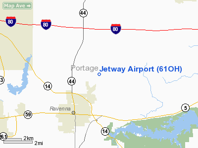
| From nearest city: | 3 nautical miles NE of Ravenna, OH |
| Location: | Portage County, OH |
| Magnetic Variation: | 07W (1985) |
Owner & Manager
| Ownership: | Privately owned |
| Owner: | Gordon L. Jennings |
| Address: | 7570 Peck Rd
Ravenna, OH 44266 |
| Phone number: | 216-296-6569 |
| Address: |
|
Airport Operations and Facilities
| Airport Use: | Private |
| Wind indicator: | Yes |
| Segmented Circle: | No |
| Control Tower: | No |
| Lighting Schedule: | PHONE REQ
ACTVT LIRL RYS 04/22 & 09/27 & REILS RYS 22 & 27 - 122.7. |
| Landing fee charge: | No |
| Sectional chart: | Detroit |
| Region: | AGL - Great Lakes |
| Boundary ARTCC: | ZOB - Cleveland |
| Tie-in FSS: | CLE - Cleveland |
| FSS on Airport: | No |
| FSS Toll Free: | 1-800-WX-BRIEF |
Airport Services
| Airframe Repair: | NONE |
| Power Plant Repair: | NONE |
Runway Information
Runway 04/22
| Dimension: | 2250 x 80 ft / 685.8 x 24.4 m |
| Surface: | TURF, |
| Edge Lights: | Low |
| |
Runway 04 |
Runway 22 |
| Traffic Pattern: | Right | Left |
| Runway End Identifier: | | Yes |
|
Runway 09/27
| Dimension: | 1600 x 90 ft / 487.7 x 27.4 m |
| Surface: | TURF, |
| Edge Lights: | Low |
| |
Runway 09 |
Runway 27 |
| Traffic Pattern: | Right | Left |
| Runway End Identifier: | | Yes |
|
Radio Navigation Aids
| ID |
Type |
Name |
Ch |
Freq |
Var |
Dist |
| AK | NDB | Akron | | 362.00 | 07W | 11.2 nm |
| BKL | NDB | Burke Lakefront | | 416.00 | 07W | 28.5 nm |
| EZE | NDB | Engel | | 226.00 | 07W | 29.0 nm |
| LQL | NDB | Lakeland | | 263.00 | 08W | 30.1 nm |
| HBD | NDB | Hubbard | | 408.00 | 08W | 30.8 nm |
| CL | NDB | Harri | | 344.00 | 07W | 35.1 nm |
| UCP | NDB | Castle | | 272.00 | 09W | 37.5 nm |
| TSO | NDB | Tolson | | 395.00 | 07W | 38.7 nm |
| AAU | NDB | Ashland | | 329.00 | 07W | 49.4 nm |
| MLR | NDB | Millersburg/dcmsnd | | 382.00 | 06W | 49.6 nm |
| ACO | VOR/DME | Akron | 091X | 114.40 | 04W | 5.4 nm |
| CXR | VOR/DME | Chardon | 074X | 112.70 | 05W | 19.3 nm |
| BSV | VOR/DME | Briggs | 071X | 112.40 | 04W | 29.3 nm |
| LNN | VOR/DME | Lost Nation | 039X | 110.20 | 08W | 30.3 nm |
| JFN | VOR/DME | Jefferson | 099X | 115.20 | 05W | 39.7 nm |
| DJB | VOR/DME | Dryer | 083X | 113.60 | 05W | 44.1 nm |
| YNG | VORTAC | Youngstown | 027X | 109.00 | 05W | 25.5 nm |
| CAK | VOT | Akron/canton Regional | | 110.60 | | 20.0 nm |
| CLE | VOT | Cleveland | | 110.40 | | 31.6 nm |
Remarks
Images and information placed above are from
http://www.airport-data.com/airport/61OH/
We thank them for the data!
| General Info
|
| Country |
United States
|
| State |
OHIO
|
| FAA ID |
61OH
|
| Latitude |
41-11-53.202N
|
| Longitude |
081-12-34.364W
|
| Elevation |
1130 feet
|
| Near City |
RAVENNA
|
We don't guarantee the information is fresh and accurate. The data may
be wrong or outdated.
For more up-to-date information please refer to other sources.
|
|


