 |
|
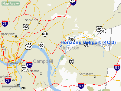
Location & QuickFacts
| FAA Information Effective: | 2008-09-25 |
| Airport Identifier: | 4OI3 |
| Airport Status: | Operational |
| Longitude/Latitude: | 084-24-35.7850W/39-07-21.2160N
-84.409940/39.122560 (Estimated) |
| Elevation: | 508 ft / 154.84 m (Estimated) |
| Land: | 12 acres |
| From nearest city: | 6 nautical miles E of Cincinnati, OH |
| Location: | Hamilton County, OH |
| Magnetic Variation: | 03W (1985) |
Owner & Manager
| Ownership: | Privately owned |
| Owner: | Joe Motz |
| Address: | 5055 Wooster Road
Cincinnati, OH 45226 |
| Phone number: | 513-871-3992 |
| Manager: | Joe Motz |
| Address: | 5055 Wooster Road
Cincinnati, OH 45226 |
| Phone number: | 513-871-3992 |
Airport Operations and Facilities
| Airport Use: | Private |
| Wind indicator: | Yes |
| Segmented Circle: | No |
| Control Tower: | No |
| Landing fee charge: | No |
| Sectional chart: | Cincinnati |
| Region: | AGL - Great Lakes |
| Boundary ARTCC: | ZID - Indianapolis |
| Tie-in FSS: | DAY - Dayton |
| FSS on Airport: | No |
| FSS Toll Free: | 1-800-WX-BRIEF |
Airport Services
| Airframe Repair: | MAJOR |
| Power Plant Repair: | MAJOR |
Runway Information
Helipad H1
| Dimension: | 100 x 100 ft / 30.5 x 30.5 m |
| Surface: | ASPH, Good Condition |
| |
Runway H1 |
Runway |
| Traffic Pattern: | Left | Left |
| Markings: | Nonstandard, Good Condition | , |
|
Radio Navigation Aids
| ID |
Type |
Name |
Ch |
Freq |
Var |
Dist |
| LUK | NDB | Cincinnati | | 335.00 | 04W | 3.9 nm |
| MDE | NDB | Madeira | | 379.00 | 04W | 6.5 nm |
| ISZ | NDB | Cincinnati-blue Ash | | 388.00 | 04W | 7.6 nm |
| PWF | NDB | Sportys | | 245.00 | 04W | 9.5 nm |
| HAO | NDB | Hamilton | | 260.00 | 04W | 16.8 nm |
| UR | NDB | Burln | | 321.00 | 04W | 17.6 nm |
| HKF | NDB | Hook Field | | 239.00 | 04W | 22.7 nm |
| HW | NDB | Cubla | | 299.00 | 04W | 28.5 nm |
| OXD | NDB | Oxford | | 282.00 | 04W | 28.9 nm |
| IL | NDB | Airbo | | 407.00 | 04W | 38.4 nm |
| HOC | NDB | Hillsboro | | 278.00 | 05W | 40.6 nm |
| HLB | NDB | Batesville | | 254.00 | 02W | 41.8 nm |
| XEN | NDB | Xenia | | 395.00 | 03W | 42.0 nm |
| AMT | NDB | West Union | | 359.00 | 04W | 42.7 nm |
| XW | NDB | Flmng | | 400.00 | 05W | 48.6 nm |
| FFO | TACAN | Patterson | 099X | | 04W | 45.0 nm |
| FLM | VOR/DME | Falmouth | 117X | 117.00 | 04W | 28.8 nm |
| MXQ | VOR/DME | Midwest | 076X | 112.90 | 04W | 33.8 nm |
| CVG | VORTAC | Cincinnati | 120X | 117.30 | 04W | 15.1 nm |
| RID | VORTAC | Richmond | 043X | 110.60 | 03W | 42.9 nm |
| LUK | VOT | Cincinnati Muni/lunken | | 108.40 | | 0.6 nm |
| DAY | VOT | Dayton J M Cox-day | | 111.00 | | 47.7 nm |
Remarks
- SIX FT FENCE 34 FT SE OF HELIPAD.
- TKOF/LNDG AREA APROPLY MKD/LGTD, NON-OBSTG WIND INDCR MAINTD ADJ TO TKOF/LNDG AREA, OPERNL AGRMT IS MAKE WITH OWNER OF MAY HELI & CINCINNATI-LUNKEN ATCT PSNL.
Images and information placed above are from
http://www.airport-data.com/airport/4OI3/
We thank them for the data!
| General Info
|
| Country |
United States
|
| State |
OHIO
|
| FAA ID |
4OI3
|
| Latitude |
39-07-21.216N
|
| Longitude |
084-24-35.785W
|
| Elevation |
508 feet
|
| Near City |
CINCINNATI
|
We don't guarantee the information is fresh and accurate. The data may
be wrong or outdated.
For more up-to-date information please refer to other sources.
|
|


