 |
|
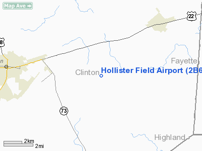
Location & QuickFacts
| FAA Information Effective: | 2008-09-25 |
| Airport Identifier: | 2B6 |
| Airport Status: | Operational |
| Longitude/Latitude: | 083-42-29.7220W/39-26-15.2230N
-83.708256/39.437562 (Estimated) |
| Elevation: | 1090 ft / 332.23 m (Estimated) |
| Land: | 32 acres |
| From nearest city: | 5 nautical miles E of Wilmington, OH |
| Location: | Clinton County, OH |
| Magnetic Variation: | 04W (1985) |
Owner & Manager
| Ownership: | Privately owned |
| Owner: | Matthew W. Ellis |
| Address: | 2326 Cherrybend Road
Wilmington, OH 45177 |
| Phone number: | 937-584-4269 |
| Manager: | Matthew W. Ellis |
| Address: | 2326 Cherrybend Road
Wilmington, OH 45177 |
| Phone number: | 937-584-4269 |
Airport Operations and Facilities
| Airport Use: | Open to public |
| Wind indicator: | Yes |
| Segmented Circle: | No |
| Control Tower: | No |
| Landing fee charge: | No |
| Sectional chart: | Cincinnati |
| Region: | AGL - Great Lakes |
| Boundary ARTCC: | ZID - Indianapolis |
| Tie-in FSS: | DAY - Dayton |
| FSS on Airport: | No |
| FSS Toll Free: | 1-800-WX-BRIEF |
| NOTAMs Facility: | DAY (NOTAM-d service avaliable) |
Airport Communications
Airport Services
Runway Information
Runway 05/23
| Dimension: | 3203 x 80 ft / 976.3 x 24.4 m |
| Surface: | TURF, Fair Condition |
| |
Runway 05 |
Runway 23 |
| Traffic Pattern: | Left | Left |
| Displaced threshold: | 92.00 ft | 565.00 ft |
| Obstruction: | 5 ft fence, 59.0 ft from runway, 11:1 slope to clear
APCH RATIO 30:1 TO DSPLCD THLD. | 24 ft pline, 38.0 ft from runway, 1:1 slope to clear
APCH RATIO 25:1 TO DSPLCD THLD. |
|
Runway 13/31
| Dimension: | 2670 x 80 ft / 813.8 x 24.4 m |
| Surface: | TURF, Fair Condition |
| |
Runway 13 |
Runway 31 |
| Traffic Pattern: | Left | Left |
| Displaced threshold: | 250.00 ft | 732.00 ft |
| Obstruction: | 5 ft fence
APCH RATIO 22:1 TO DSPLCD THLD; +50 FT PLINE 1105 FT FM DSPLCD THLD 0B. | 5 ft fence, 0.0 ft from runway, 108 ft left of centerline
APCH RATIO 12:1 OVER +95 FT TREE 1161 FT FM DSPLCD THLD 148 FT L. |
|
Radio Navigation Aids
| ID |
Type |
Name |
Ch |
Freq |
Var |
Dist |
| IL | NDB | Airbo | | 407.00 | 04W | 3.5 nm |
| HW | NDB | Cubla | | 299.00 | 04W | 9.3 nm |
| HOC | NDB | Hillsboro | | 278.00 | 05W | 17.0 nm |
| CSS | NDB | Court House | | 414.00 | 05W | 17.7 nm |
| XEN | NDB | Xenia | | 395.00 | 03W | 19.6 nm |
| CCJ | NDB | Clark County | | 341.00 | 04W | 26.4 nm |
| RZT | NDB | Ross County | | 236.00 | 05W | 31.5 nm |
| UYF | NDB | London | | 263.00 | 06W | 31.9 nm |
| PWF | NDB | Sportys | | 245.00 | 04W | 32.1 nm |
| BU | NDB | Boutn | | 230.00 | 05W | 32.7 nm |
| MDE | NDB | Madeira | | 379.00 | 04W | 32.7 nm |
| ISZ | NDB | Cincinnati-blue Ash | | 388.00 | 04W | 33.6 nm |
| LUK | NDB | Cincinnati | | 335.00 | 04W | 33.9 nm |
| CYO | NDB | Circleville | | 366.00 | 05W | 34.2 nm |
| HKF | NDB | Hook Field | | 239.00 | 04W | 34.5 nm |
| AMT | NDB | West Union | | 359.00 | 04W | 35.6 nm |
| PZO | NDB | Peebles | | 329.00 | 02W | 35.8 nm |
| EOP | NDB | Waverly | | 385.00 | 06W | 39.6 nm |
| HAO | NDB | Hamilton | | 260.00 | 04W | 40.3 nm |
| OS | NDB | Fuler | | 515.00 | 05W | 44.9 nm |
| CHC | NDB | Grens | | 272.00 | 04W | 46.6 nm |
| DKG | NDB | Don Scott | | 348.00 | 05W | 48.4 nm |
| OXD | NDB | Oxford | | 282.00 | 04W | 49.9 nm |
| XSF | TACAN | Springfield | 065X | | 04W | 24.8 nm |
| FFO | TACAN | Patterson | 099X | | 04W | 28.0 nm |
| LCK | TACAN | Rickenbacker | 069X | | 05W | 42.4 nm |
| XUB | VOR | Yellow Bud | | 112.50 | 05W | 34.3 nm |
| MXQ | VOR/DME | Midwest | 076X | 112.90 | 04W | 4.3 nm |
| SGH | VOR/DME | Springfield | 079X | 113.20 | 04W | 24.8 nm |
| DQN | VOR/DME | Dayton | 092X | 114.50 | 01W | 47.2 nm |
| DAY | VOT | Dayton J M Cox-day | | 111.00 | | 36.6 nm |
| LUK | VOT | Cincinnati Muni/lunken | | 108.40 | | 37.5 nm |
Remarks
- CTN-PHEASANTS RELEASED N SIDE OF RWY FOR HUNTING SEP-APR.
- MODEL ACFT RDO CTL AREA S OF RY 23.
- RY 13 ADDL OBSTNS +50 FT PLINE 860 FT R 0 FT B.
- RY 31 ADDL OBSTNS +35 FT PLINE 265 FT R 0 FT B & +95 FT TREE 429 FT R 148 FT L.
- CALL FOR RY COND PRIOR TO LDG FR NOV - APR.
Images and information placed above are from
http://www.airport-data.com/airport/2B6/
We thank them for the data!
| General Info
|
| Country |
United States
|
| State |
OHIO
|
| FAA ID |
2B6
|
| Latitude |
39-26-15.223N
|
| Longitude |
083-42-29.722W
|
| Elevation |
1090 feet
|
| Near City |
WILMINGTON
|
We don't guarantee the information is fresh and accurate. The data may
be wrong or outdated.
For more up-to-date information please refer to other sources.
|
|


