 |
|
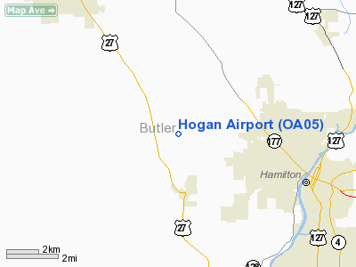
Location & QuickFacts
| FAA Information Effective: | 2008-09-25 |
| Airport Identifier: | OA05 |
| Airport Status: | Operational |
| Longitude/Latitude: | 084-39-32.8180W/39-25-27.1970N
-84.659116/39.424221 (Estimated) |
| Elevation: | 865 ft / 263.65 m (Estimated) |
| Land: | 25 acres |
| From nearest city: | 2 nautical miles SE of Mc Gonigle, OH |
| Location: | Butler County, OH |
| Magnetic Variation: | 04W (1995) |
Owner & Manager
| Ownership: | Privately owned |
| Owner: | Clifford F. Hogan |
| Address: | 3020 Stahlheber Road
Hamilton, OH 45013 |
| Phone number: | 513-887-7420 |
| Manager: | Clifford F. Hogan |
| Address: | 3020 Stahlheber Road
Hamilton, OH 45013 |
| Phone number: | 513-856-7420 |
Airport Operations and Facilities
| Airport Use: | Private |
| Wind indicator: | Yes |
| Segmented Circle: | No |
| Control Tower: | No |
| Sectional chart: | Cincinnati |
| Region: | AGL - Great Lakes |
| Boundary ARTCC: | ZID - Indianapolis |
| Tie-in FSS: | DAY - Dayton |
| FSS on Airport: | No |
| FSS Toll Free: | 1-800-WX-BRIEF |
Runway Information
Runway 01/19
| Dimension: | 2000 x 50 ft / 609.6 x 15.2 m |
| Surface: | TURF, |
| |
Runway 01 |
Runway 19 |
| Traffic Pattern: | Left | Left |
| Obstruction: | 35 ft pline | 35 ft trees, 0.0 ft from runway |
|
Radio Navigation Aids
| ID |
Type |
Name |
Ch |
Freq |
Var |
Dist |
| HAO | NDB | Hamilton | | 260.00 | 04W | 5.1 nm |
| OXD | NDB | Oxford | | 282.00 | 04W | 7.5 nm |
| HKF | NDB | Hook Field | | 239.00 | 04W | 10.8 nm |
| ISZ | NDB | Cincinnati-blue Ash | | 388.00 | 04W | 16.4 nm |
| MDE | NDB | Madeira | | 379.00 | 04W | 18.6 nm |
| LUK | NDB | Cincinnati | | 335.00 | 04W | 21.7 nm |
| UR | NDB | Burln | | 321.00 | 04W | 23.4 nm |
| HLB | NDB | Batesville | | 254.00 | 02W | 28.2 nm |
| PWF | NDB | Sportys | | 245.00 | 04W | 29.4 nm |
| HW | NDB | Cubla | | 299.00 | 04W | 36.6 nm |
| XEN | NDB | Xenia | | 395.00 | 03W | 38.0 nm |
| UWL | NDB | New Castle | | 385.00 | 02W | 41.0 nm |
| IL | NDB | Airbo | | 407.00 | 04W | 43.0 nm |
| VES | NDB | Versailles | | 356.00 | 04W | 47.4 nm |
| CCJ | NDB | Clark County | | 341.00 | 04W | 48.9 nm |
| OVO | NDB | North Vernon | | 374.00 | 02W | 49.3 nm |
| FFO | TACAN | Patterson | 099X | | 04W | 36.7 nm |
| XSF | TACAN | Springfield | 065X | | 04W | 45.3 nm |
| DQN | VOR/DME | Dayton | 092X | 114.50 | 01W | 37.6 nm |
| MXQ | VOR/DME | Midwest | 076X | 112.90 | 04W | 39.8 nm |
| SGH | VOR/DME | Springfield | 079X | 113.20 | 04W | 45.1 nm |
| FLM | VOR/DME | Falmouth | 117X | 117.00 | 04W | 49.3 nm |
| RID | VORTAC | Richmond | 043X | 110.60 | 03W | 21.6 nm |
| CVG | VORTAC | Cincinnati | 120X | 117.30 | 04W | 24.6 nm |
| LUK | VOT | Cincinnati Muni/lunken | | 108.40 | | 22.1 nm |
| DAY | VOT | Dayton J M Cox-day | | 111.00 | | 35.2 nm |
Remarks
- OBSTNS IN RY APCH SLOPE SHOULD BE REMOVED OR LOWERED OR RY THLD DSPLCD TO PROVIDE 20:1 APCH CLNC; 125 FT EITHER SIDE OF RY CNTRLN CLEARED.
Images and information placed above are from
http://www.airport-data.com/airport/OA05/
We thank them for the data!
| General Info
|
| Country |
United States
|
| State |
OHIO
|
| FAA ID |
OA05
|
| Latitude |
39-25-27.197N
|
| Longitude |
084-39-32.818W
|
| Elevation |
800 feet
|
| Near City |
MC GONIGLE
|
We don't guarantee the information is fresh and accurate. The data may
be wrong or outdated.
For more up-to-date information please refer to other sources.
|
|


