 |
|
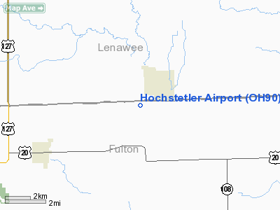
Location & QuickFacts
| FAA Information Effective: | 2008-09-25 |
| Airport Identifier: | OH90 |
| Airport Status: | Operational |
| Longitude/Latitude: | 084-14-05.0000W/41-42-26.1810N
-84.234722/41.707273 (Estimated) |
| Elevation: | 763 ft / 232.56 m (Estimated) |
| Land: | 0 acres |
| From nearest city: | 7 nautical miles W of Lyons, OH |
| Location: | Fulton County, OH |
| Magnetic Variation: | 05W (1985) |
Owner & Manager
| Ownership: | Privately owned |
| Owner: | Gaylord Hochstetler |
| Address: | P.o. Box 331
Lyons, OH 43533 |
| Phone number: | 419-923-2375 |
| Address: |
|
Airport Operations and Facilities
| Airport Use: | Private |
| Wind indicator: | Yes |
| Segmented Circle: | No |
| Control Tower: | No |
| Sectional chart: | Detroit |
| Region: | AGL - Great Lakes |
| Boundary ARTCC: | ZOB - Cleveland |
| Tie-in FSS: | CLE - Cleveland |
| FSS on Airport: | No |
| FSS Toll Free: | 1-800-WX-BRIEF |
Runway Information
Runway 09/27
| Dimension: | 1800 x 100 ft / 548.6 x 30.5 m |
| Surface: | TURF, |
| |
Runway 09 |
Runway 27 |
| Traffic Pattern: | Left | Left |
|
Radio Navigation Aids
| ID |
Type |
Name |
Ch |
Freq |
Var |
Dist |
| USE | NDB | Fulton | | 375.00 | 05W | 7.5 nm |
| ADG | NDB | Adrian | | 278.00 | 06W | 12.1 nm |
| BYN | NDB | Bryan | | 260.00 | 04W | 17.2 nm |
| DFI | NDB | Defiance | | 246.00 | 05W | 24.0 nm |
| TCU | NDB | Tecumseh | | 239.00 | 04W | 25.3 nm |
| ANQ | NDB | Angola | | 347.00 | 05W | 38.5 nm |
| PDR | NDB | Ottawa | | 233.00 | 05W | 42.3 nm |
| BNR | NDB | Benton Ridge | | 334.00 | 05W | 48.5 nm |
| FZI | NDB | Fostoria | | 379.00 | 05W | 49.0 nm |
| TOL | TACAN | Toledo | 072X | | 05W | 20.7 nm |
| MAH | VOR | Marathon | | 114.90 | 05W | 48.9 nm |
| VWV | VOR/DME | Waterville | 078X | 113.10 | 02W | 30.9 nm |
| LFD | VOR/DME | Litchfield | 049X | 111.20 | 05W | 31.9 nm |
| JXN | VOR/DME | Jackson | 033X | 109.60 | 05W | 34.7 nm |
| DXO | VOR/DME | Detroit | 081X | 113.40 | 06W | 49.3 nm |
| CRL | VORTAC | Carleton | 104X | 115.70 | 03W | 40.4 nm |
| YIP | VOT | Willow Run | | 112.00 | | 44.9 nm |
| DTW | VOT | Detroit Met Wayne | | 109.80 | | 49.9 nm |
Remarks
- E111: PRVDD ALL TFC PAT OPNS AT HOCHSTETLER ARE CONDUCTED ON THE SOUTH SIDE OF THE E/W RWY; TFC PAT INDCRS ARE INSTALLED & ALL TFC PAT OPNS AT MORENCI ARPT ARE CONDUCTED ON THE NORTH SIDE OF THE E/W RWY.
Images and information placed above are from
http://www.airport-data.com/airport/OH90/
We thank them for the data!
| General Info
|
| Country |
United States
|
| State |
OHIO
|
| FAA ID |
OH90
|
| Latitude |
41-44-00.961N
|
| Longitude |
081-13-08.963W
|
| Elevation |
697 feet
|
| Near City |
PAINESVILLE
|
We don't guarantee the information is fresh and accurate. The data may
be wrong or outdated.
For more up-to-date information please refer to other sources.
|
|


