 |
|
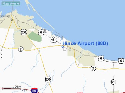
Location & QuickFacts
| FAA Information Effective: | 2008-09-25 |
| Airport Identifier: | 88D |
| Airport Status: | Operational |
| Longitude/Latitude: | 082-36-04.6330W/41-24-13.1780N
-82.601287/41.403661 (Estimated) |
| Elevation: | 609 ft / 185.62 m (Surveyed) |
| Land: | 20 acres |
| From nearest city: | 3 nautical miles NW of Huron, OH |
| Location: | Erie County, OH |
| Magnetic Variation: | 06W (1985) |
Owner & Manager
| Ownership: | Privately owned |
| Owner: | Elaine H & Joseph A Bores |
| Address: | 1819 Boos Rd
Huron, OH 44839 |
| Phone number: | 419-433-2075 |
| Manager: | Joseph & Elaine Bores |
| Address: | 1819 Boos Rd
Huron, OH 44839 |
| Phone number: | 419-433-2075
ADDNL NR 216-324-4494. |
Airport Operations and Facilities
| Airport Use: | Open to public |
| Wind indicator: | Yes |
| Segmented Circle: | No |
| Control Tower: | No |
| Landing fee charge: | No |
| Sectional chart: | Detroit |
| Region: | AGL - Great Lakes |
| Boundary ARTCC: | ZOB - Cleveland |
| Tie-in FSS: | CLE - Cleveland |
| FSS on Airport: | No |
| FSS Toll Free: | 1-800-WX-BRIEF |
| NOTAMs Facility: | CLE (NOTAM-d service avaliable) |
Airport Communications
Airport Services
Runway Information
Runway 11/29
| Dimension: | 2500 x 70 ft / 762.0 x 21.3 m |
| Surface: | TURF, Good Condition |
| |
Runway 11 |
Runway 29 |
| Longitude: | 082-36-20.2300W | 082-35-49.0300W |
| Latitude: | 41-24-16.9800N | 41-24-09.3500N |
| Elevation: | 609.00 ft | 609.00 ft |
| Traffic Pattern: | Left | Left |
| Obstruction: | 24 ft road, 120 ft left of centerline | 28 ft brush, 19.0 ft from runway, 120 ft right of centerline |
|
Radio Navigation Aids
| ID |
Type |
Name |
Ch |
Freq |
Var |
Dist |
| PCW | NDB | Port Clinton | | 423.00 | 06W | 13.9 nm |
| PT | NDB | Pelee Island | | 283.00 | 05W | 22.8 nm |
| CL | NDB | Harri | | 344.00 | 07W | 29.0 nm |
| AAU | NDB | Ashland | | 329.00 | 07W | 30.8 nm |
| TII | NDB | Tiffin | | 269.00 | 05W | 33.0 nm |
| FZI | NDB | Fostoria | | 379.00 | 05W | 38.2 nm |
| MF | NDB | Manns | | 372.00 | 06W | 39.0 nm |
| EZE | NDB | Engel | | 226.00 | 07W | 39.9 nm |
| BKL | NDB | Burke Lakefront | | 416.00 | 07W | 42.9 nm |
| RYS | NDB | Grosse Ile | | 419.00 | 06W | 48.7 nm |
| SKY | VOR/DME | Sandusky | 029X | 109.20 | 04W | 3.0 nm |
| DJB | VOR/DME | Dryer | 083X | 113.60 | 05W | 20.0 nm |
| VWV | VOR/DME | Waterville | 078X | 113.10 | 02W | 46.8 nm |
| MFD | VORTAC | Mansfield | 025X | 108.80 | 03W | 32.2 nm |
| CLE | VOT | Cleveland | | 110.40 | | 33.9 nm |
Remarks
- RY SOFT WHEN WET.
- ARPT CLSD AT NIGHT
Images and information placed above are from
http://www.airport-data.com/airport/88D/
We thank them for the data!
| General Info
|
| Country |
United States
|
| State |
OHIO
|
| FAA ID |
88D
|
| Latitude |
41-24-13.178N
|
| Longitude |
082-36-04.633W
|
| Elevation |
609 feet
|
| Near City |
HURON
|
We don't guarantee the information is fresh and accurate. The data may
be wrong or outdated.
For more up-to-date information please refer to other sources.
|
|


