 |
|
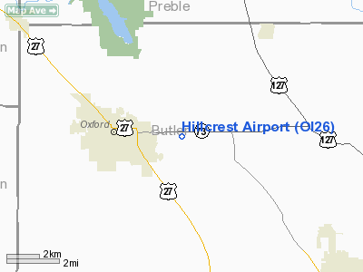
Location & QuickFacts
| FAA Information Effective: | 2008-09-25 |
| Airport Identifier: | OI26 |
| Airport Status: | Operational |
| Longitude/Latitude: | 084-41-55.8200W/39-30-20.1900N
-84.698839/39.505608 (Estimated) |
| Elevation: | 890 ft / 271.27 m (Estimated) |
| Land: | 0 acres |
| From nearest city: | 2 nautical miles E of Oxford, OH |
| Location: | Butler County, OH |
| Magnetic Variation: | 03W (1990) |
Owner & Manager
| Ownership: | Privately owned |
| Owner: | Douglas M. Fey |
| Address: | Park Place West; P.o. Box 238
Oxford, OH 45056-0238 |
| Phone number: | 513-523-6341 |
| Manager: | Douglas M. Fey |
| Address: | Park Place West; P.o. Box 238
Oxford, OH 45056-0238 |
| Phone number: | 513-523-6341 |
Airport Operations and Facilities
| Airport Use: | Private
PERSONAL USE. |
| Wind indicator: | Yes |
| Segmented Circle: | No |
| Control Tower: | No |
| Sectional chart: | Cincinnati |
| Region: | AGL - Great Lakes |
| Boundary ARTCC: | ZID - Indianapolis |
| Tie-in FSS: | DAY - Dayton |
| FSS Toll Free: | 1-800-WX-BRIEF |
Runway Information
Runway 18/36
| Dimension: | 1000 x 200 ft / 304.8 x 61.0 m |
| Surface: | TURF, |
| |
Runway 18 |
Runway 36 |
| Traffic Pattern: | Left | Left |
|
Radio Navigation Aids
| ID |
Type |
Name |
Ch |
Freq |
Var |
Dist |
| OXD | NDB | Oxford | | 282.00 | 04W | 3.8 nm |
| HAO | NDB | Hamilton | | 260.00 | 04W | 9.9 nm |
| HKF | NDB | Hook Field | | 239.00 | 04W | 11.7 nm |
| ISZ | NDB | Cincinnati-blue Ash | | 388.00 | 04W | 21.1 nm |
| MDE | NDB | Madeira | | 379.00 | 04W | 23.3 nm |
| LUK | NDB | Cincinnati | | 335.00 | 04W | 26.6 nm |
| HLB | NDB | Batesville | | 254.00 | 02W | 27.6 nm |
| UR | NDB | Burln | | 321.00 | 04W | 27.9 nm |
| PWF | NDB | Sportys | | 245.00 | 04W | 34.2 nm |
| UWL | NDB | New Castle | | 385.00 | 02W | 36.5 nm |
| XEN | NDB | Xenia | | 395.00 | 03W | 37.8 nm |
| HW | NDB | Cubla | | 299.00 | 04W | 39.3 nm |
| VES | NDB | Versailles | | 356.00 | 04W | 42.9 nm |
| IL | NDB | Airbo | | 407.00 | 04W | 44.6 nm |
| CCJ | NDB | Clark County | | 341.00 | 04W | 47.9 nm |
| FFO | TACAN | Patterson | 099X | | 04W | 35.2 nm |
| XSF | TACAN | Springfield | 065X | | 04W | 44.5 nm |
| DQN | VOR/DME | Dayton | 092X | 114.50 | 01W | 33.7 nm |
| MXQ | VOR/DME | Midwest | 076X | 112.90 | 04W | 41.9 nm |
| SGH | VOR/DME | Springfield | 079X | 113.20 | 04W | 44.2 nm |
| RID | VORTAC | Richmond | 043X | 110.60 | 03W | 16.3 nm |
| CVG | VORTAC | Cincinnati | 120X | 117.30 | 04W | 29.4 nm |
| LUK | VOT | Cincinnati Muni/lunken | | 108.40 | | 27.2 nm |
| DAY | VOT | Dayton J M Cox-day | | 111.00 | | 32.5 nm |
Remarks
- PRVDD OBSTN IN RY APCH SLOPE BE REMOVED/LOWERED OR THE RY THR BE DSPLCD & MARKED TO PRVD A 20:1 APCH SLOPE AREA 125 FT EITHER SIDE OF RY CNTRLN & 200 FT OFF RY END BE CLEAR OF OBSTN.
Images and information placed above are from
http://www.airport-data.com/airport/OI26/
We thank them for the data!
| General Info
|
| Country |
United States
|
| State |
OHIO
|
| FAA ID |
OI26
|
| Latitude |
39-30-20.190N
|
| Longitude |
084-41-55.820W
|
| Elevation |
890 feet
|
| Near City |
OXFORD
|
We don't guarantee the information is fresh and accurate. The data may
be wrong or outdated.
For more up-to-date information please refer to other sources.
|
|


