 |
|
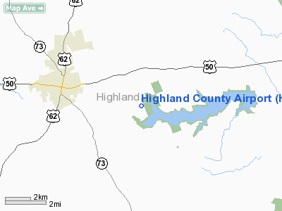
| Highland County Airport |
| IATA: none – ICAO: KHOC – FAA LID: HOC |
| Summary |
| Airport type |
Public |
| Elevation AMSL |
977 ft / 297.8 m |
| Coordinates |
39°11.33′N 83°32.34′W / 39.18883°N 83.539°W / 39.18883; -83.539 |
| Runways |
| Direction |
Length |
Surface |
| ft |
m |
| 5 / 23 |
3,520 |
1,073 |
Asphalt |
Highland County Airport (KHOC) is an airport in Highland County, Ohio. Located just east of Hillsboro, Ohio. The airport averaged 38 flights per day during 2008-2009. It is owned by Highland County.
The above content comes from Wikipedia and is published under free licenses – click here to read more.
Location & QuickFacts
| FAA Information Effective: | 2008-09-25 |
| Airport Identifier: | HOC |
| Airport Status: | Operational |
| Longitude/Latitude: | 083-32-19.6495W/39-11-19.5408N
-83.538792/39.188761 (Estimated) |
| Elevation: | 977 ft / 297.79 m (Surveyed) |
| Land: | 15 acres |
| From nearest city: | 3 nautical miles SE of Hillsboro, OH |
| Location: | Highland County, OH |
| Magnetic Variation: | 05W (1990) |
Owner & Manager
| Ownership: | Publicly owned |
| Owner: | Highland County Commissioners
CTC DAN COWDREY, AIRPORT AUTHORITY PRES. |
| Address: | Highland County Courthouse
Hillsboro, OH 45133 |
| Phone number: | 937-393-0339 |
| Manager: | Dan Cowdrey - Bob Skoog |
| Address: | 9500 North Shore Drive
|
| Phone number: | 937-393-9112 |
Airport Operations and Facilities
| Airport Use: | Open to public |
| Wind indicator: | Yes |
| Segmented Circle: | No |
| Control Tower: | No |
| Lighting Schedule: | DUSK-DAWN
ACTVT MIRL RY 05/23 AND REIL RY 23 - CTAF. |
| Beacon Color: | Clear-Green (lighted land airport) |
| Landing fee charge: | No |
| Sectional chart: | Cincinnati |
| Region: | AGL - Great Lakes |
| Traffic Pattern Alt: | 700 ft |
| Boundary ARTCC: | ZID - Indianapolis |
| Tie-in FSS: | DAY - Dayton |
| FSS on Airport: | No |
| FSS Toll Free: | 1-800-WX-BRIEF |
| NOTAMs Facility: | DAY (NOTAM-d service avaliable) |
| Federal Agreements: | N |
Airport Communications
| CTAF: | 123.050 |
| Unicom: | 123.050 |
Airport Services
| Fuel available: | 100LLA |
| Airframe Repair: | MAJOR |
| Power Plant Repair: | MAJOR |
Runway Information
Runway 05/23
| Dimension: | 3520 x 75 ft / 1072.9 x 22.9 m |
| Surface: | ASPH, Good Condition |
| Weight Limit: | Single wheel: 25000 lbs. |
| Edge Lights: | Medium
LGTS NW SIDE OTS INDEFLY. |
| |
Runway 05 |
Runway 23 |
| Longitude: | 083-32-36.5914W | 083-32-02.7061W |
| Latitude: | 39-11-08.1961N | 39-11-30.8849N |
| Elevation: | 977.00 ft | 931.00 ft |
| Alignment: | 49 | 127 |
| Traffic Pattern: | Left | Left |
| Markings: | Non-precision instrument, Good Condition | Non-precision instrument, Good Condition |
| VASI: | | 2-light PAPI on left side |
| Runway End Identifier: | No | Yes
OTS INDEFLY. |
| Centerline Lights: | No | No |
| Touchdown Lights: | No | No |
| Obstruction: | 36 ft trees, 324.0 ft from runway, 240 ft right of centerline, 3:1 slope to clear | 47 ft trees, 1265.0 ft from runway, 120 ft left of centerline, 22:1 slope to clear |
|
Radio Navigation Aids
| ID |
Type |
Name |
Ch |
Freq |
Var |
Dist |
| HOC | NDB | Hillsboro | | 278.00 | 05W | 0.3 nm |
| HW | NDB | Cubla | | 299.00 | 04W | 18.5 nm |
| PZO | NDB | Peebles | | 329.00 | 02W | 18.9 nm |
| AMT | NDB | West Union | | 359.00 | 04W | 20.0 nm |
| IL | NDB | Airbo | | 407.00 | 04W | 20.4 nm |
| CSS | NDB | Court House | | 414.00 | 05W | 25.7 nm |
| RZT | NDB | Ross County | | 236.00 | 05W | 28.1 nm |
| EOP | NDB | Waverly | | 385.00 | 06W | 28.3 nm |
| PWF | NDB | Sportys | | 245.00 | 04W | 32.3 nm |
| CYO | NDB | Circleville | | 366.00 | 05W | 32.8 nm |
| XEN | NDB | Xenia | | 395.00 | 03W | 36.5 nm |
| XW | NDB | Flmng | | 400.00 | 05W | 37.3 nm |
| LUK | NDB | Cincinnati | | 335.00 | 04W | 37.4 nm |
| MDE | NDB | Madeira | | 379.00 | 04W | 38.1 nm |
| ISZ | NDB | Cincinnati-blue Ash | | 388.00 | 04W | 39.8 nm |
| PMH | NDB | Portsmouth | | 373.00 | 04W | 40.6 nm |
| BU | NDB | Boutn | | 230.00 | 05W | 40.9 nm |
| CCJ | NDB | Clark County | | 341.00 | 04W | 42.6 nm |
| UYF | NDB | London | | 263.00 | 06W | 44.9 nm |
| HKF | NDB | Hook Field | | 239.00 | 04W | 46.2 nm |
| HAO | NDB | Hamilton | | 260.00 | 04W | 49.3 nm |
| XSF | TACAN | Springfield | 065X | | 04W | 41.5 nm |
| FFO | TACAN | Patterson | 099X | | 04W | 44.8 nm |
| LCK | TACAN | Rickenbacker | 069X | | 05W | 46.8 nm |
| XUB | VOR | Yellow Bud | | 112.50 | 05W | 33.1 nm |
| MXQ | VOR/DME | Midwest | 076X | 112.90 | 04W | 18.9 nm |
| SGH | VOR/DME | Springfield | 079X | 113.20 | 04W | 41.4 nm |
| FLM | VOR/DME | Falmouth | 117X | 117.00 | 04W | 48.5 nm |
| YRK | VORTAC | York | 075X | 112.80 | 05W | 41.9 nm |
| LUK | VOT | Cincinnati Muni/lunken | | 108.40 | | 40.4 nm |
Images and information placed above are from
http://www.airport-data.com/airport/HOC/
We thank them for the data!
| General Info
|
| Country |
United States
|
| State |
OHIO
|
| FAA ID |
HOC
|
| Latitude |
39-11-19.534N
|
| Longitude |
083-32-19.705W
|
| Elevation |
978 feet
|
| Near City |
HILLSBORO
|
We don't guarantee the information is fresh and accurate. The data may
be wrong or outdated.
For more up-to-date information please refer to other sources.
|
|


