 |
|
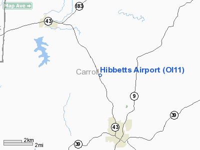
Location & QuickFacts
| FAA Information Effective: | 2008-09-25 |
| Airport Identifier: | OI11 |
| Airport Status: | Operational |
| Longitude/Latitude: | 081-06-45.3570W/40-38-14.2200N
-81.112599/40.637283 (Estimated) |
| Elevation: | 1060 ft / 323.09 m (Estimated) |
| Land: | 0 acres |
| From nearest city: | 4 nautical miles SE of Carrollton, OH |
| Location: | Carroll County, OH |
| Magnetic Variation: | 07W (1985) |
Owner & Manager
| Ownership: | Privately owned |
| Owner: | Burton L & H Melvene Lawrence |
| Address: | 4066 Canton Rd Nw
Carrollton, OH 44615 |
| Phone number: | 216-627-3394 |
| Manager: | Burton L Lawrence |
| Address: | 4094 Canton Rd Nw
Carrollton, OH 44615 |
| Phone number: | 216-627-3394 |
Airport Operations and Facilities
| Airport Use: | Private |
| Wind indicator: | Yes |
| Segmented Circle: | No |
| Control Tower: | No |
| Landing fee charge: | No |
| Sectional chart: | Detroit |
| Region: | AGL - Great Lakes |
| Boundary ARTCC: | ZOB - Cleveland |
| Tie-in FSS: | CLE - Cleveland |
| FSS on Airport: | No |
| FSS Toll Free: | 1-800-WX-BRIEF |
Runway Information
Runway 15/33
| Dimension: | 2815 x 60 ft / 858.0 x 18.3 m |
| Surface: | TURF, |
| |
Runway 15 |
Runway 33 |
| Traffic Pattern: | Left | Right |
| Obstruction: | 75 ft trees, 400.0 ft from runway | 75 ft tower, 400.0 ft from runway |
|
Radio Navigation Aids
| ID |
Type |
Name |
Ch |
Freq |
Var |
Dist |
| TSO | NDB | Tolson | | 395.00 | 07W | 4.8 nm |
| CFX | NDB | Cadiz | | 239.00 | 07W | 24.5 nm |
| AK | NDB | Akron | | 362.00 | 07W | 28.8 nm |
| MLR | NDB | Millersburg/dcmsnd | | 382.00 | 06W | 35.2 nm |
| UCP | NDB | Castle | | 272.00 | 09W | 39.3 nm |
| HBD | NDB | Hubbard | | 408.00 | 08W | 40.7 nm |
| BSV | VOR/DME | Briggs | 071X | 112.40 | 04W | 15.8 nm |
| ACO | VOR/DME | Akron | 091X | 114.40 | 04W | 28.6 nm |
| CTW | VOR/DME | Newcomerstown | 055X | 111.80 | 07W | 29.6 nm |
| HLG | VOR/DME | Wheeling | 059X | 112.20 | 07W | 33.7 nm |
| AIR | VOR/DME | Bellaire | 118X | 117.10 | 07W | 39.7 nm |
| TVT | VOR/DME | Tiverton | 112X | 116.50 | 03W | 47.6 nm |
| EWC | VORTAC | Ellwood City | 105X | 115.80 | 08W | 42.6 nm |
| MMJ | VORTAC | Montour | 057X | 112.00 | 08W | 42.9 nm |
| YNG | VORTAC | Youngstown | 027X | 109.00 | 05W | 46.2 nm |
| CAK | VOT | Akron/canton Regional | | 110.60 | | 22.5 nm |
Remarks
- VFR WX CONDS ONLY. ALL OPERATIONS CONDUCTED ON SW SIDE OF NW/SE RWY.
Images and information placed above are from
http://www.airport-data.com/airport/OI11/
We thank them for the data!
| General Info
|
| Country |
United States
|
| State |
OHIO
|
| FAA ID |
OI11
|
| Latitude |
40-38-14.220N
|
| Longitude |
081-06-45.357W
|
| Elevation |
1060 feet
|
| Near City |
CARROLLTON
|
We don't guarantee the information is fresh and accurate. The data may
be wrong or outdated.
For more up-to-date information please refer to other sources.
|
|


