 |
|
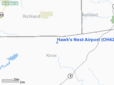
Location & QuickFacts
| FAA Information Effective: | 2008-09-25 |
| Airport Identifier: | OH42 |
| Airport Status: | Operational |
| Longitude/Latitude: | 082-23-37.5860W/40-32-24.2200N
-82.393774/40.540061 (Estimated) |
| Elevation: | 1260 ft / 384.05 m (Estimated) |
| Land: | 0 acres |
| From nearest city: | 3 nautical miles S of Butler, OH |
| Location: | Knox County, OH |
| Magnetic Variation: | 06W (1985) |
Owner & Manager
| Ownership: | Privately owned |
| Owner: | Richard M. Lattimer |
| Address: | Rd 2
Butler, OH 44822 |
| Phone number: | 614-694-8890 |
| Address: |
|
Airport Operations and Facilities
| Airport Use: | Private |
| Wind indicator: | Yes |
| Segmented Circle: | No |
| Control Tower: | No |
| Landing fee charge: | No |
| Sectional chart: | Detroit |
| Region: | AGL - Great Lakes |
| Boundary ARTCC: | ZID - Indianapolis |
| Tie-in FSS: | CLE - Cleveland |
| FSS on Airport: | No |
| FSS Toll Free: | 1-800-WX-BRIEF |
Airport Services
| Airframe Repair: | NONE |
| Power Plant Repair: | NONE |
Runway Information
Runway 02/20
| Dimension: | 2000 x 60 ft / 609.6 x 18.3 m |
| Surface: | TURF, |
| |
Runway 02 |
Runway 20 |
| Traffic Pattern: | Left | Left |
|
Radio Navigation Aids
| ID |
Type |
Name |
Ch |
Freq |
Var |
Dist |
| MF | NDB | Manns | | 372.00 | 06W | 13.8 nm |
| MLR | NDB | Millersburg/dcmsnd | | 382.00 | 06W | 23.8 nm |
| AAU | NDB | Ashland | | 329.00 | 07W | 26.2 nm |
| HEH | NDB | Newark | | 524.00 | 06W | 31.1 nm |
| MNN | NDB | Marion | | 201.00 | 05W | 31.2 nm |
| DLZ | NDB | Delaware | | 215.00 | 06W | 36.1 nm |
| CM | NDB | Sumie | | 391.00 | 05W | 37.2 nm |
| DKG | NDB | Don Scott | | 348.00 | 05W | 41.8 nm |
| CHC | NDB | Grens | | 272.00 | 04W | 43.2 nm |
| HRA | NDB | Zanesville | | 204.00 | 06W | 43.9 nm |
| OS | NDB | Fuler | | 515.00 | 05W | 46.3 nm |
| MRT | NDB | Marysville | | 403.00 | 05W | 47.6 nm |
| TII | NDB | Tiffin | | 269.00 | 05W | 50.0 nm |
| BUD | VOR | Buckeye | | 109.80 | 05W | 30.9 nm |
| TVT | VOR/DME | Tiverton | 112X | 116.50 | 03W | 13.2 nm |
| ZZV | VOR/DME | Zanesville | 051X | 111.40 | 06W | 42.7 nm |
| BSV | VOR/DME | Briggs | 071X | 112.40 | 04W | 45.5 nm |
| CTW | VOR/DME | Newcomerstown | 055X | 111.80 | 07W | 46.0 nm |
| MFD | VORTAC | Mansfield | 025X | 108.80 | 03W | 21.7 nm |
| APE | VORTAC | Appleton | 114X | 116.70 | 06W | 25.0 nm |
| CMH | VOT | Port Columbus | | 111.00 | | 39.8 nm |
| CAK | VOT | Akron/canton Regional | | 110.60 | | 48.9 nm |
Remarks
- PVT USE ONLY, EMGCY USE BY OTHERS ONLY.
- VFR WEA COND ONLY.
Images and information placed above are from
http://www.airport-data.com/airport/OH42/
We thank them for the data!
| General Info
|
| Country |
United States
|
| State |
OHIO
|
| FAA ID |
OH42
|
| Latitude |
40-32-24.220N
|
| Longitude |
082-23-37.586W
|
| Elevation |
1260 feet
|
| Near City |
BUTLER
|
We don't guarantee the information is fresh and accurate. The data may
be wrong or outdated.
For more up-to-date information please refer to other sources.
|
|


