Greater Portsmouth Rgnl Airport in Ohio Ohio airports - Greater Portsmouth Rgnl Airport
Greater Portsmouth Rgnl Airport in Ohio - United States
Ohio Airports
USA Airports
World Airports
Airport photos
Aircraft photos
Spacecraft photos
Earth from airplane
Earth from space
Aviation Articles

Greater Portsmouth Rgnl Airport


Greater Portsmouth Regional Airport
IATA: PMH – ICAO: KPMH
Summary
Airport type Public
Operator Scioto County Airport Authority
Location Portsmouth, Ohio
Elevation AMSL 663 ft / 202.1 m
Coordinates 38°50′26″N 82°50′50″W / 38.84056°N 82.84722°W / 38.84056; -82.84722Coordinates: 38°50′26″N 82°50′50″W / 38.84056°N 82.84722°W / 38.84056; -82.84722
Runways
Direction Length Surface
ft m
18R/36L 5006 1526 Asphalt

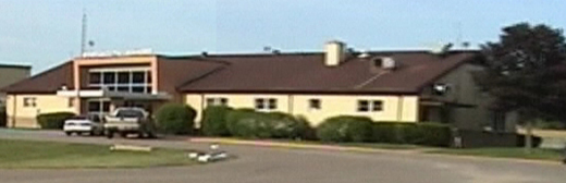
Greater Portsmouth Regional Airport (IATA:PMH, ICAO:KPMH) also known as Scioto County Airport is an airport located about a mile south of Minford, Ohio and ten miles northeast of Portsmouth, Ohio. The airport offers fuel services along with a small snack bar, a couple of hangars, mechanics, and pilot snooze room.

History

The airport was constructed in the 1957 to replace another airport located in West Portsmouth, Ohio which was situated near the Ohio River. When it first opened, Lake Central Airlines offered services to the airport until Allegheny Air merged with them in 1968. Since then, the airport has been without airline services and is today used for corporate and business services flying out of Portsmouth, Ohio and for flight training.

The current president of the Airport Board is George Crumm.

References and external links

  • Portsmouth Region Aviation School
  • FAA Info By Airnav


The above content comes from Wikipedia and is published under free licenses – click here to read more.

Greater Portsmouth Rgnl Airport picture

Greater Portsmouth Rgnl Airport picture
(Click on the photo to enlarge)


Greater Portsmouth Rgnl Airport picture
(Click on the photo to enlarge)


Location & QuickFacts

FAA Information Effective:2008-09-25
Airport Identifier:PMH
Airport Status:Operational
Longitude/Latitude:082-50-50.3000W/38-50-25.7000N
-82.847306/38.840472 (Estimated)
Elevation:663 ft / 202.08 m (Surveyed)
Land:246 acres
From nearest city:10 nautical miles NE of Portsmouth, OH
Location:Scioto County, OH
Magnetic Variation:05W (1995)

Owner & Manager

Ownership:Publicly owned
Owner:Scioto County Arpt Authority
Address:P.o. Box 245
Wheelersburg, OH 45694
Phone number:740-574-6827
Manager:Paul Claxton
Address:P.o. Box 245
Wheelersburg, OH 45694
Phone number:740-820-2700

Airport Operations and Facilities

Airport Use:Open to public
Wind indicator:Yes
Segmented Circle:Yes
Control Tower:No
Lighting Schedule:DUSK-DAWN
ACTVT MIRL RY 18/36; REIL RYS 18 & 36 - CTAF.
Beacon Color:Clear-Green (lighted land airport)
Sectional chart:Cincinnati
Region:AGL - Great Lakes
Boundary ARTCC:ZID - Indianapolis
Tie-in FSS:DAY - Dayton
FSS Toll Free:1-800-WX-BRIEF
NOTAMs Facility:DAY (NOTAM-d service avaliable)
Federal Agreements:NGY

Airport Communications

CTAF:122.800
Unicom:122.800 

Airport Services

Fuel available:100LLA1+
Airframe Repair:MAJOR
Power Plant Repair:MAJOR

Runway Information

Runway 18/36

Dimension:5001 x 100 ft / 1524.3 x 30.5 m
Surface:ASPH, Good Condition
Weight Limit:Single wheel: 30000 lbs.
Dual wheel: 42000 lbs.
Dual tandem wheel: 70000 lbs.
Edge Lights:Medium
 

Runway 18

Runway 36

Longitude:082-50-51.5356W082-50-49.0944W
Latitude:38-50-50.3941N38-50-00.9995N
Elevation:659.00 ft655.00 ft
Alignment:127127
Traffic Pattern:RightLeft
Markings:Non-precision instrument, Good ConditionNon-precision instrument, Good Condition
Crossing Height:26.00 ft31.00 ft
VASI:4-light PAPI on left side4-light PAPI on left side
Runway End Identifier:YesYes
OTS INDEFLY.
Obstruction:35 ft trees, 700.0 ft from runway, 293 ft right of centerline, 14:1 slope to clear13 ft tree, 201.0 ft from runway, 250 ft left of centerline

Radio Navigation Aids

ID Type Name Ch Freq Var Dist
AJYFAN MARKERAshland 03W17.2 nm
PMHNDBPortsmouth373.0004W3.5 nm
EOPNDBWaverly385.0006W20.0 nm
PZONDBPeebles329.0002W23.0 nm
GASNDBGallipolis420.0007W32.1 nm
AMTNDBWest Union359.0004W33.6 nm
RZTNDBRoss County236.0005W36.9 nm
HOCNDBHillsboro278.0005W38.5 nm
XWNDBFlmng400.0005W40.8 nm
CYONDBCircleville366.0005W41.5 nm
UGSNDBUniversity250.0006W42.0 nm
XUBVORYellow Bud112.5005W41.7 nm
YRKVORTACYork075X112.8005W13.3 nm
HNNVORTACHenderson106X115.9003W38.8 nm
ECBVORTACNewcombe041X110.4002W41.1 nm

Remarks

  • HILL OBSTN LGTS 460 FT ABV ARPT (1124 FT MSL) 1 MI S & 410 FT ABV ARPT (1074 FT MSL) 1/2 MI NW.
  • ACFT NOT VISIBLE FROM ONE RY END TO ANOTHER OR NO LINE OF SIGHT BTWN RY ENDS.
  • IN OPER PRIOR TO 1959.

Images and information placed above are from
http://www.airport-data.com/airport/PMH/

We thank them for the data!


General Info
Country United States
State OHIO
FAA ID PMH
Latitude 38-50-25.692N
Longitude 082-50-50.329W
Elevation 663 feet
Near City PORTSMOUTH


We don't guarantee the information is fresh and accurate. The data may be wrong or outdated.
For more up-to-date information please refer to other sources.


christianity portal
directory of hotels worldwide


Copyright 2004-2024 © by Airports-Worldwide.com, Vyshenskoho st. 36, Lviv 79010, Ukraine
Legal Disclaimer