 |
|
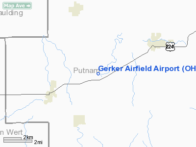
Location & QuickFacts
| FAA Information Effective: | 2008-09-25 |
| Airport Identifier: | OH60 |
| Airport Status: | Operational |
| Longitude/Latitude: | 084-16-24.8120W/40-57-13.1810N
-84.273559/40.953661 (Estimated) |
| Elevation: | 780 ft / 237.74 m (Estimated) |
| Land: | 3 acres |
| From nearest city: | 5 nautical miles SW of Fort Jennings, OH |
| Location: | Putnam County, OH |
| Magnetic Variation: | 04W (1985) |
Owner & Manager
| Ownership: | Privately owned |
| Owner: | David Gerker |
| Address: | 15570 Rd 22-k
Fort Jennings, OH 45844 |
| Phone number: | 419-286-2007 |
| Manager: | David Gerker |
| Address: | 15570 Rd 22-k
Fort Jennings, OH 45844 |
| Phone number: | 419-286-2007 |
Airport Operations and Facilities
| Airport Use: | Private |
| Wind indicator: | Yes |
| Segmented Circle: | No |
| Control Tower: | No |
| Sectional chart: | Detroit |
| Region: | AGL - Great Lakes |
| Boundary ARTCC: | ZOB - Cleveland |
| Tie-in FSS: | CLE - Cleveland |
| FSS on Airport: | No |
| FSS Toll Free: | 1-800-WX-BRIEF |
Airport Services
Runway Information
Runway 09/27
| Dimension: | 2000 x 50 ft / 609.6 x 15.2 m |
| Surface: | TURF, |
| |
Runway 09 |
Runway 27 |
| Traffic Pattern: | Left | Left |
| Obstruction: | | 25 ft pline, 200.0 ft from runway |
|
Radio Navigation Aids
| ID |
Type |
Name |
Ch |
Freq |
Var |
Dist |
| PDR | NDB | Ottawa | | 233.00 | 05W | 14.3 nm |
| VFU | NDB | Stanley | | 411.00 | 05W | 16.4 nm |
| LYL | NDB | Lima | | 362.00 | 04W | 18.8 nm |
| DFI | NDB | Defiance | | 246.00 | 05W | 23.9 nm |
| BNR | NDB | Benton Ridge | | 334.00 | 05W | 27.7 nm |
| CQA | NDB | Lakefield | | 205.00 | 04W | 31.3 nm |
| BYN | NDB | Bryan | | 260.00 | 04W | 32.8 nm |
| USE | NDB | Fulton | | 375.00 | 05W | 39.9 nm |
| RUV | NDB | Rushsylvania | | 326.00 | 05W | 40.6 nm |
| EDJ | NDB | Bellefontaine | | 242.00 | 05W | 40.8 nm |
| FZI | NDB | Fostoria | | 379.00 | 05W | 42.2 nm |
| PLD | NDB | Portland | | 257.00 | 03W | 44.2 nm |
| VES | NDB | Versailles | | 356.00 | 04W | 46.3 nm |
| TII | NDB | Tiffin | | 269.00 | 05W | 49.1 nm |
| TOL | TACAN | Toledo | 072X | | 05W | 44.0 nm |
| AOH | VOR | Allen County | | 108.40 | 04W | 20.3 nm |
| MAH | VOR | Marathon | | 114.90 | 05W | 27.9 nm |
| VWV | VOR/DME | Waterville | 078X | 113.10 | 02W | 41.5 nm |
| FDY | VORTAC | Findlay | 019X | 108.20 | 02W | 23.5 nm |
| ROD | VORTAC | Rosewood | 122X | 117.50 | 05W | 41.4 nm |
| FWA | VORTAC | Fort Wayne | 125X | 117.80 | 00E | 41.5 nm |
| FWA | VOT | Fort Wayne Baer | | 111.00 | | 41.7 nm |
Remarks
Images and information placed above are from
http://www.airport-data.com/airport/OH60/
We thank them for the data!
| General Info
|
| Country |
United States
|
| State |
OHIO
|
| FAA ID |
OH60
|
| Latitude |
40-57-13.181N
|
| Longitude |
084-16-24.812W
|
| Elevation |
780 feet
|
| Near City |
FORT JENNINGS
|
We don't guarantee the information is fresh and accurate. The data may
be wrong or outdated.
For more up-to-date information please refer to other sources.
|
|


