 |
|
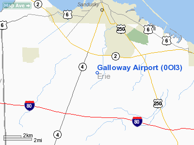
Location & QuickFacts
| FAA Information Effective: | 2008-09-25 |
| Airport Identifier: | 0OI3 |
| Airport Status: | Operational |
| Longitude/Latitude: | 082-42-58.0000W/41-22-55.5600N
-82.716111/41.382100 (Estimated) |
| Elevation: | 643 ft / 195.99 m (Estimated) |
| Land: | 0 acres |
| From nearest city: | 3 nautical miles S of Sandusky, OH |
| Location: | Erie County, OH |
| Magnetic Variation: | 06W (1995) |
Owner & Manager
| Ownership: | Privately owned |
| Owner: | Galloway & Sons |
| Address: | 1810 Schenk Rd
Sandusky, OH 44870 |
| Phone number: | 419-625-5951 |
| Manager: | Doug Galloway |
| Address: | 1810 Schenk Rd
Sandusky, OH 44870 |
| Phone number: | 419-625-5951 |
Airport Operations and Facilities
| Airport Use: | Private |
| Segmented Circle: | No |
| Control Tower: | No |
| Sectional chart: | Detroit |
| Region: | AGL - Great Lakes |
| Boundary ARTCC: | ZOB - Cleveland |
| Tie-in FSS: | CLE - Cleveland |
| FSS Toll Free: | 1-800-WX-BRIEF |
Runway Information
Runway 09/27
| Dimension: | 1900 x 70 ft / 579.1 x 21.3 m |
| Surface: | TURF, |
| |
Runway 09 |
Runway 27 |
| Traffic Pattern: | Left | Left |
| Displaced threshold: | 0.00 ft | 800.00 ft
DSPLCD THLD MKD WITH TIRES. |
| Obstruction: | | 50 ft tree, 1000.0 ft from runway |
|
Radio Navigation Aids
| ID |
Type |
Name |
Ch |
Freq |
Var |
Dist |
| PCW | NDB | Port Clinton | | 423.00 | 06W | 10.7 nm |
| PT | NDB | Pelee Island | | 283.00 | 05W | 24.0 nm |
| TII | NDB | Tiffin | | 269.00 | 05W | 28.0 nm |
| AAU | NDB | Ashland | | 329.00 | 07W | 32.7 nm |
| FZI | NDB | Fostoria | | 379.00 | 05W | 32.8 nm |
| CL | NDB | Harri | | 344.00 | 07W | 34.0 nm |
| MF | NDB | Manns | | 372.00 | 06W | 39.0 nm |
| EZE | NDB | Engel | | 226.00 | 07W | 45.2 nm |
| RYS | NDB | Grosse Ile | | 419.00 | 06W | 47.5 nm |
| BKL | NDB | Burke Lakefront | | 416.00 | 07W | 48.2 nm |
| BNR | NDB | Benton Ridge | | 334.00 | 05W | 48.3 nm |
| MNN | NDB | Marion | | 201.00 | 05W | 48.7 nm |
| MAH | VOR | Marathon | | 114.90 | 05W | 48.2 nm |
| BUD | VOR | Buckeye | | 109.80 | 05W | 48.6 nm |
| SKY | VOR/DME | Sandusky | 029X | 109.20 | 04W | 4.2 nm |
| DJB | VOR/DME | Dryer | 083X | 113.60 | 05W | 25.0 nm |
| VWV | VOR/DME | Waterville | 078X | 113.10 | 02W | 41.8 nm |
| MFD | VORTAC | Mansfield | 025X | 108.80 | 03W | 31.4 nm |
| CLE | VOT | Cleveland | | 110.40 | | 39.1 nm |
Remarks
- PRVDD THE AREA 125 FT EITHER SIDE OF RY CNTRLN & 200 FT OFF RY ENDS IS CLEAR; ANY OBSTN REMOVED OR LOWERED TO PRVD A CLEAR 20:1 APCH.
Images and information placed above are from
http://www.airport-data.com/airport/0OI3/
We thank them for the data!
| General Info
|
| Country |
United States
|
| State |
OHIO
|
| FAA ID |
0OI3
|
| Latitude |
41-22-55.560N
|
| Longitude |
082-42-58.000W
|
| Elevation |
643 feet
|
| Near City |
SANDUSKY
|
We don't guarantee the information is fresh and accurate. The data may
be wrong or outdated.
For more up-to-date information please refer to other sources.
|
|


