 |
|
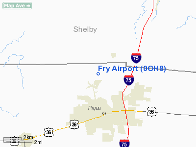
Location & QuickFacts
| FAA Information Effective: | 2008-09-25 |
| Airport Identifier: | 0OH8 |
| Airport Status: | Operational |
| Longitude/Latitude: | 084-15-21.8020W/40-11-18.1790N
-84.256056/40.188383 (Estimated) |
| Elevation: | 900 ft / 274.32 m (Estimated) |
| Land: | 0 acres |
| From nearest city: | 2 nautical miles S of Piqua, OH |
| Location: | Miami County, OH |
| Magnetic Variation: | 04W (1985) |
Owner & Manager
| Ownership: | Privately owned |
| Owner: | Lloyd B. Fry |
| Address: | 10328 Hardin Rd
Piqua, OH 45356 |
| Phone number: | 513-773-3613 |
| Address: |
|
Airport Operations and Facilities
| Airport Use: | Private |
| Wind indicator: | Yes |
| Segmented Circle: | No |
| Control Tower: | No |
| Landing fee charge: | No |
| Sectional chart: | Detroit |
| Region: | AGL - Great Lakes |
| Boundary ARTCC: | ZID - Indianapolis |
| Tie-in FSS: | DAY - Dayton |
| FSS on Airport: | No |
| FSS Toll Free: | 1-800-WX-BRIEF |
Airport Services
| Airframe Repair: | NONE |
| Power Plant Repair: | NONE |
Runway Information
Runway 03/21
| Dimension: | 3000 x 50 ft / 914.4 x 15.2 m |
| Surface: | ASPH, |
| |
Runway 03 |
Runway 21 |
| Traffic Pattern: | Right | Left |
|
Radio Navigation Aids
| ID |
Type |
Name |
Ch |
Freq |
Var |
Dist |
| VES | NDB | Versailles | | 356.00 | 04W | 12.3 nm |
| CQA | NDB | Lakefield | | 205.00 | 04W | 22.6 nm |
| EDJ | NDB | Bellefontaine | | 242.00 | 05W | 23.1 nm |
| CCJ | NDB | Clark County | | 341.00 | 04W | 29.0 nm |
| RUV | NDB | Rushsylvania | | 326.00 | 05W | 31.5 nm |
| XEN | NDB | Xenia | | 395.00 | 03W | 32.2 nm |
| LYL | NDB | Lima | | 362.00 | 04W | 32.8 nm |
| PLD | NDB | Portland | | 257.00 | 03W | 37.0 nm |
| UYF | NDB | London | | 263.00 | 06W | 39.4 nm |
| MRT | NDB | Marysville | | 403.00 | 05W | 41.7 nm |
| HKF | NDB | Hook Field | | 239.00 | 04W | 42.4 nm |
| VFU | NDB | Stanley | | 411.00 | 05W | 43.7 nm |
| OXD | NDB | Oxford | | 282.00 | 04W | 47.5 nm |
| IL | NDB | Airbo | | 407.00 | 04W | 48.2 nm |
| OS | NDB | Fuler | | 515.00 | 05W | 49.1 nm |
| FFO | TACAN | Patterson | 099X | | 04W | 24.0 nm |
| XSF | TACAN | Springfield | 065X | | 04W | 28.4 nm |
| AOH | VOR | Allen County | | 108.40 | 04W | 33.8 nm |
| DQN | VOR/DME | Dayton | 092X | 114.50 | 01W | 12.2 nm |
| SGH | VOR/DME | Springfield | 079X | 113.20 | 04W | 28.4 nm |
| ROD | VORTAC | Rosewood | 122X | 117.50 | 05W | 11.5 nm |
| RID | VORTAC | Richmond | 043X | 110.60 | 03W | 37.4 nm |
| DAY | VOT | Dayton J M Cox-day | | 111.00 | | 17.3 nm |
Remarks
- HIGH PWR LINES ALOOF RWY BTWN RD AND RWY.
- VFR ONLY; TFC FLOWN TO SE OF RWY 3-21, RIGHT TURN WHEN RWY 3 IN USE. HEL ASP: VFR ONLY.
Images and information placed above are from
http://www.airport-data.com/airport/0OH8/
We thank them for the data!
| General Info
|
| Country |
United States
|
| State |
OHIO
|
| FAA ID |
0OH8
|
| Latitude |
40-11-18.179N
|
| Longitude |
084-15-21.802W
|
| Elevation |
900 feet
|
| Near City |
PIQUA
|
We don't guarantee the information is fresh and accurate. The data may
be wrong or outdated.
For more up-to-date information please refer to other sources.
|
|


