 |
|
| Fremont Airport |
| IATA: none – ICAO: none – FAA LID: 14G |
| Summary |
| Airport type |
Public |
| Owner |
Eugene Damschroder |
| Serves |
Sandusky County |
| Location |
Fremont, Ohio |
| Elevation AMSL |
663 ft / 202 m |
| Coordinates |
41°19′59″N 083°09′40″W / 41.33306°N 83.16111°W / 41.33306; -83.16111 |
| Runways |
| Direction |
Length |
Surface |
| ft |
m |
| 09/27 |
4,137 |
1,261 |
Asphalt |
| 18/36 |
2,238 |
682 |
Turf |
| Statistics (2008) |
| Aircraft operations |
37,450 |
| Based aircraft |
67 |
| Source: Federal Aviation Administration |
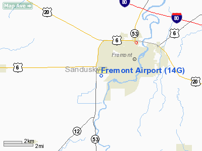
Fremont Airport (FAA LID: 14G) is a public-use airport located two nautical miles (4 km) southwest of the central business district of Fremont, a city in Sandusky County, Ohio, United States. It is privately owned by Eugene Damschroder.
Facilities and aircraft
Fremont Airport covers an area of 84 acres (34 ha) at an elevation of 663 feet (202 m) above mean sea level. It has two runways: 9/27 is 4,137 by 60 feet (1,261 x 18 m) with an asphalt pavement; 18/36 is 2,238 by 130 feet (682 x 40 m) with a turf surface.
For the 12-month period ending May 19, 2008, the airport had 37,450 aircraft operations, an average of 102 per day: 96% general aviation, 4% air taxi and <1% military. At that time there were 67 aircraft based at this airport: 82% single-engine, 12% multi-engine and 6% ultralight.
The above content comes from Wikipedia and is published under free licenses – click here to read more.
Location & QuickFacts
| FAA Information Effective: | 2008-09-25 |
| Airport Identifier: | 14G |
| Airport Status: | Operational |
| Longitude/Latitude: | 083-09-40.3000W/41-19-59.1000N
-83.161194/41.333083 (Estimated) |
| Elevation: | 663 ft / 202.08 m (Surveyed) |
| Land: | 84 acres |
| From nearest city: | 2 nautical miles SW of Fremont, OH |
| Location: | Sandusky County, OH |
| Magnetic Variation: | 05W (1985) |
Owner & Manager
| Ownership: | Privately owned |
| Owner: | Eugene Damschroder |
| Address: | 365 S Sr53
Fremont, OH 43420 |
| Phone number: | 419-332-8037 |
| Manager: | Eugene Damschroder |
| Address: | 365 S Sr53
Fremont, OH 43420 |
| Phone number: | 419-332-8037
ALSO CALL 419-332-5649. |
Airport Operations and Facilities
| Airport Use: | Open to public |
| Wind indicator: | Yes |
| Segmented Circle: | No |
| Control Tower: | No |
| Lighting Schedule: | RDO-CTL
ACTVT LIRL RY 09/27; REIL RY 09 AND ROTG BCN - CTAF. |
| Beacon Color: | Clear-Green (lighted land airport) |
| Landing fee charge: | No |
| Sectional chart: | Detroit |
| Region: | AGL - Great Lakes |
| Boundary ARTCC: | ZOB - Cleveland |
| Tie-in FSS: | CLE - Cleveland |
| FSS on Airport: | No |
| FSS Toll Free: | 1-800-WX-BRIEF |
| NOTAMs Facility: | CLE (NOTAM-d service avaliable) |
Airport Communications
| CTAF: | 122.800 |
| Unicom: | 122.800 |
Airport Services
| Fuel available: | 100LL80
FOR FUEL AFTER HRS CALL 419-332-0046. |
| Airframe Repair: | MAJOR |
| Power Plant Repair: | MAJOR |
Runway Information
Runway 09/27
| Dimension: | 4137 x 60 ft / 1261.0 x 18.3 m |
| Surface: | ASPH, Fair Condition |
| Weight Limit: | Single wheel: 13000 lbs. |
| Edge Lights: | Low |
| |
Runway 09 |
Runway 27 |
| Longitude: | 083-10-02.6831W | 083-09-08.4592W |
| Latitude: | 41-20-03.2139N | 41-20-03.0170N |
| Elevation: | 652.00 ft | 660.00 ft |
| Alignment: | 90 | 127 |
| Traffic Pattern: | Left | Left |
| Markings: | Nonstandard, Fair Condition
RY 09 DSPLCD THLD MARKINGS FADED, WEATHERED. | Nonstandard, Fair Condition |
| Displaced threshold: | 126.00 ft | 0.00 ft |
| VASI: | nonstandard system | |
| Runway End Identifier: | Yes | No |
| Centerline Lights: | No | No |
| Touchdown Lights: | No | No |
| Obstruction: | 10 ft road, 210.0 ft from runway, 1:1 slope to clear
APCH SLOPE TO DSPLCD THLD 0:1 DUE TO +27 FT BLDGS; 0 FT FM DSPLCD THLD 126 FT R.
RD; 120 FT FM RY END 250 FT L & 250 FT R; +5 FT SIGNS 90 FT FM RY END 130 FT L. | 56 ft trees, 201.0 ft from runway
RY 27 APCH SLOPE TO DSPLCD THLD 0:1 DUE TO +56 FT TREES; 0 FT FM DSPLCD THLD 142 FT L.
RY 27 TERRAIN OFF RY END DROPS 15 FT OFF APCH END; +0 FT-56 FT TREES/BRUSH 0 FT FM 142 FT L-250 FT L TO 200 FT FM 142 FT L-250 FT L. |
|
Runway 18/36
| Dimension: | 2238 x 130 ft / 682.1 x 39.6 m |
| Surface: | TURF, Fair Condition |
| |
Runway 18 |
Runway 36 |
| Longitude: | 083-09-48.9055W | 083-09-49.4256W |
| Latitude: | 41-20-02.7808N | 41-19-40.6715N |
| Elevation: | 654.00 ft | 657.00 ft |
| Alignment: | 127 | 1 |
| Traffic Pattern: | Left | Left |
| Obstruction: | 80 ft trees, 262.0 ft from runway, 94 ft left of centerline, 3:1 slope to clear | 26 ft pline, 0.0 ft from runway |
|
Radio Navigation Aids
| ID |
Type |
Name |
Ch |
Freq |
Var |
Dist |
| FZI | NDB | Fostoria | | 379.00 | 05W | 13.7 nm |
| TII | NDB | Tiffin | | 269.00 | 05W | 14.3 nm |
| PCW | NDB | Port Clinton | | 423.00 | 06W | 17.3 nm |
| BNR | NDB | Benton Ridge | | 334.00 | 05W | 29.7 nm |
| PT | NDB | Pelee Island | | 283.00 | 05W | 34.8 nm |
| PDR | NDB | Ottawa | | 233.00 | 05W | 41.1 nm |
| MNN | NDB | Marion | | 201.00 | 05W | 43.2 nm |
| RYS | NDB | Grosse Ile | | 419.00 | 06W | 46.2 nm |
| AAU | NDB | Ashland | | 329.00 | 07W | 46.7 nm |
| USE | NDB | Fulton | | 375.00 | 05W | 46.8 nm |
| MF | NDB | Manns | | 372.00 | 06W | 47.1 nm |
| TOL | TACAN | Toledo | 072X | | 05W | 32.7 nm |
| MAH | VOR | Marathon | | 114.90 | 05W | 29.7 nm |
| BUD | VOR | Buckeye | | 109.80 | 05W | 43.3 nm |
| VWV | VOR/DME | Waterville | 078X | 113.10 | 02W | 22.7 nm |
| SKY | VOR/DME | Sandusky | 029X | 109.20 | 04W | 23.6 nm |
| DJB | VOR/DME | Dryer | 083X | 113.60 | 05W | 45.1 nm |
| FDY | VORTAC | Findlay | 019X | 108.20 | 02W | 35.2 nm |
| MFD | VORTAC | Mansfield | 025X | 108.80 | 03W | 38.0 nm |
| CRL | VORTAC | Carleton | 104X | 115.70 | 03W | 45.0 nm |
Images and information placed above are from
http://www.airport-data.com/airport/14G/
We thank them for the data!
| General Info
|
| Country |
United States
|
| State |
OHIO
|
| FAA ID |
14G
|
| Latitude |
41-20-03.100N
|
| Longitude |
083-09-35.600W
|
| Elevation |
663 feet
|
| Near City |
FREMONT
|
We don't guarantee the information is fresh and accurate. The data may
be wrong or outdated.
For more up-to-date information please refer to other sources.
|
|


