 |
|
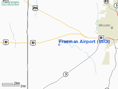
Location & QuickFacts
| FAA Information Effective: | 2008-09-25 |
| Airport Identifier: | 66OI |
| Airport Status: | Operational |
| Longitude/Latitude: | 082-03-20.5380W/40-46-53.2050N
-82.055705/40.781446 (Estimated) |
| Elevation: | 1210 ft / 368.81 m (Estimated) |
| Land: | 7 acres |
| From nearest city: | 6 nautical miles W of Wooster, OH |
| Location: | Wayne County, OH |
| Magnetic Variation: | 05W (1980) |
Owner & Manager
| Ownership: | Privately owned |
| Owner: | Gayle & Dan Freeman |
| Address: | Po Box 168
Wooster, OH 44691 |
| Phone number: | 216-264-3422 |
| Address: |
|
Airport Operations and Facilities
| Airport Use: | Private |
| Wind indicator: | Yes |
| Segmented Circle: | No |
| Control Tower: | No |
| Sectional chart: | Detroit |
| Region: | AGL - Great Lakes |
| Boundary ARTCC: | ZOB - Cleveland |
| Tie-in FSS: | CLE - Cleveland |
| FSS Toll Free: | 1-800-WX-BRIEF |
Runway Information
Runway 16/34
| Dimension: | 3000 x 100 ft / 914.4 x 30.5 m |
| Surface: | TURF, |
| |
Runway 16 |
Runway 34 |
| Traffic Pattern: | Left | Left |
| Displaced threshold: | 540.00 ft | 0.00 ft |
| Obstruction: | 30 ft pline, 60.0 ft from runway | |
|
Radio Navigation Aids
| ID |
Type |
Name |
Ch |
Freq |
Var |
Dist |
| AAU | NDB | Ashland | | 329.00 | 07W | 14.2 nm |
| MLR | NDB | Millersburg/dcmsnd | | 382.00 | 06W | 16.7 nm |
| MF | NDB | Manns | | 372.00 | 06W | 17.7 nm |
| CL | NDB | Harri | | 344.00 | 07W | 33.7 nm |
| AK | NDB | Akron | | 362.00 | 07W | 34.9 nm |
| EZE | NDB | Engel | | 226.00 | 07W | 45.1 nm |
| TSO | NDB | Tolson | | 395.00 | 07W | 46.5 nm |
| MNN | NDB | Marion | | 201.00 | 05W | 47.3 nm |
| BKL | NDB | Burke Lakefront | | 416.00 | 07W | 48.3 nm |
| HEH | NDB | Newark | | 524.00 | 06W | 49.1 nm |
| BUD | VOR | Buckeye | | 109.80 | 05W | 47.0 nm |
| TVT | VOR/DME | Tiverton | 112X | 116.50 | 03W | 19.7 nm |
| BSV | VOR/DME | Briggs | 071X | 112.40 | 04W | 28.5 nm |
| DJB | VOR/DME | Dryer | 083X | 113.60 | 05W | 35.0 nm |
| CTW | VOR/DME | Newcomerstown | 055X | 111.80 | 07W | 42.5 nm |
| ACO | VOR/DME | Akron | 091X | 114.40 | 04W | 43.5 nm |
| SKY | VOR/DME | Sandusky | 029X | 109.20 | 04W | 47.7 nm |
| MFD | VORTAC | Mansfield | 025X | 108.80 | 03W | 24.9 nm |
| APE | VORTAC | Appleton | 114X | 116.70 | 06W | 45.0 nm |
| CAK | VOT | Akron/canton Regional | | 110.60 | | 29.1 nm |
| CLE | VOT | Cleveland | | 110.40 | | 38.9 nm |
Remarks
- OWNER DESIRES ARPT NOT BE CHARTED.
- PRVDD OBSTRUCTIONS REMOVED/LOWERED TO PROVIDE 20:1 CLEARANCE; REFER TO ADVISORY CIRCULAR TO ESTABLISH LEVEL OF SAFETY FOR ACFT.
Images and information placed above are from
http://www.airport-data.com/airport/66OI/
We thank them for the data!
| General Info
|
| Country |
United States
|
| State |
OHIO
|
| FAA ID |
66OI
|
| Latitude |
40-46-53.205N
|
| Longitude |
082-03-20.538W
|
| Elevation |
1210 feet
|
| Near City |
WOOSTER
|
We don't guarantee the information is fresh and accurate. The data may
be wrong or outdated.
For more up-to-date information please refer to other sources.
|
|


