|
|
Fostoria Metropolitan Airport |
| Fostoria Metropolitan Airport |
| IATA: none – ICAO: KFZI – FAA LID: FZI |
| Summary |
| Airport type |
Public |
| Owner |
City of Fostoria |
| Serves |
Fostoria, Ohio |
| Elevation AMSL |
752 ft / 229 m |
| Coordinates |
41°11′27″N 083°23′40″W / 41.19083°N 83.39444°W / 41.19083; -83.39444 |
| Runways |
| Direction |
Length |
Surface |
| ft |
m |
| 9/27 |
4,200 |
1,280 |
Asphalt |
| Statistics (2008) |
| Aircraft operations |
7,900 |
| Based aircraft |
14 |
| Source: Federal Aviation Administration |
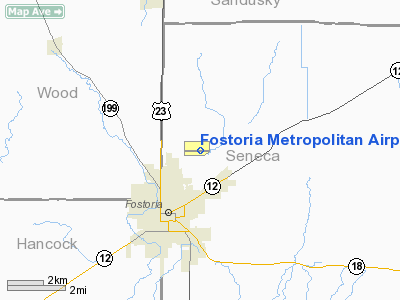
Fostoria Metropolitan Airport (ICAO: KFZI, FAA LID: FZI) is a city-owned, public-use airport located two nautical miles (3.7 km) northeast of the central business district of Fostoria, a city in Hancock, Seneca, and Wood Counties, Ohio, United States. According to the FAA's National Plan of Integrated Airport Systems for 2009-2013, it was classified as a general aviation airport.
Although most U.S. airports use the same three-letter location identifier for the FAA and IATA, this airport is assigned FZI by the FAA but has no designation from the IATA.
Facilities and aircraft
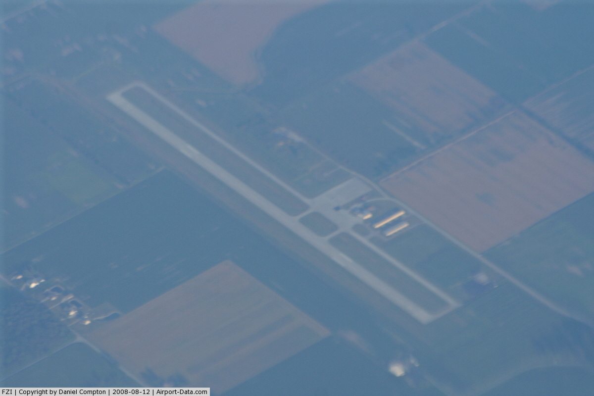
Fostoria Metropolitan Airport covers an area of 201 acres (81 ha) at an elevation of 752 feet (229 m) above mean sea level. It has one runway designated 9/27 with an asphalt surface measuring 4,200 by 100 feet (1,280 x 30 m).
For the 12-month period ending May 19, 2008, the airport had 7,900 aircraft operations, an average of 21 per day: 95% general aviation and 5% air taxi. At that time there were 14 aircraft based at this airport: 93% single-engine and 7% jet.
The above content comes from Wikipedia and is published under free licenses – click here to read more.
 |
(Click on the photo to enlarge) |
Location & QuickFacts
| FAA Information Effective: | 2008-09-25 |
| Airport Identifier: | FZI |
| Airport Status: | Operational |
| Longitude/Latitude: | 083-23-40.3000W/41-11-27.0000N
-83.394528/41.190833 (Estimated) |
| Elevation: | 752 ft / 229.21 m (Surveyed) |
| Land: | 201 acres |
| From nearest city: | 2 nautical miles NE of Fostoria, OH |
| Location: | Seneca County, OH |
| Magnetic Variation: | 05W (1985) |
Owner & Manager
| Ownership: | Publicly owned |
| Owner: | City Of Fostoria |
| Address: | 4495 N. Seneca County Rd 5
Fostoria, OH 44830 |
| Phone number: | 419-435-0157 |
| Manager: | David Sniffen |
| Address: | 4495 N. Seneca County Rd. 25
Fostoria, OH 44830 |
| Phone number: | 419-435-0157 |
Airport Operations and Facilities
| Airport Use: | Open to public |
| Wind indicator: | Yes |
| Segmented Circle: | Yes |
| Control Tower: | No |
| Lighting Schedule: | DUSK-DAWN
ACTIVATE MIRL RY 09/27 AND REIL RYS 09 & 27-CTAF. |
| Beacon Color: | Clear-Green (lighted land airport) |
| Landing fee charge: | No |
| Sectional chart: | Detroit |
| Region: | AGL - Great Lakes |
| Boundary ARTCC: | ZOB - Cleveland |
| Tie-in FSS: | CLE - Cleveland |
| FSS on Airport: | No |
| FSS Toll Free: | 1-800-WX-BRIEF |
| NOTAMs Facility: | CLE (NOTAM-d service avaliable) |
| Federal Agreements: | NGVY |
Airport Communications
| CTAF: | 122.700 |
| Unicom: | 122.700 |
Airport Services
| Fuel available: | 100LLA |
| Airframe Repair: | MAJOR |
| Power Plant Repair: | MAJOR |
Runway Information
Runway 09/27
| Dimension: | 4200 x 100 ft / 1280.2 x 30.5 m |
| Surface: | ASPH, Fair Condition |
| Weight Limit: | Single wheel: 30000 lbs.
Dual wheel: 35000 lbs.
Dual tandem wheel: 52000 lbs. |
| Edge Lights: | Medium |
| |
Runway 09 |
Runway 27 |
| Longitude: | 083-24-07.7792W | 083-23-12.8435W |
| Latitude: | 41-11-26.9451N | 41-11-27.0350N |
| Elevation: | 751.00 ft | 751.00 ft |
| Alignment: | 90 | 127 |
| Traffic Pattern: | Left | Left |
| Markings: | Non-precision instrument, Good Condition | Non-precision instrument, Good Condition |
| Crossing Height: | 25.00 ft | 25.00 ft |
| VASI: | 4-light PAPI on left side
PAPI RYS 09 & 27 ON LOW INTST 24 HRS. TO INCREASE INTST TO HIGH CLICK 122.7 SEVEN TIMES. | 4-light PAPI on left side |
| Visual Glide Angle: | 3.00° | 3.00° |
| Runway End Identifier: | Yes
RY 09 REIL OTS INDEFLY. | Yes |
| Centerline Lights: | No | No |
| Touchdown Lights: | No | No |
| Obstruction: | 80 ft trees, 3500.0 ft from runway, 40:1 slope to clear | 66 ft tree, 3400.0 ft from runway, 400 ft right of centerline, 48:1 slope to clear |
|
Radio Navigation Aids
| ID |
Type |
Name |
Ch |
Freq |
Var |
Dist |
| FZI | NDB | Fostoria | | 379.00 | 05W | 0.1 nm |
| TII | NDB | Tiffin | | 269.00 | 05W | 10.1 nm |
| BNR | NDB | Benton Ridge | | 334.00 | 05W | 16.1 nm |
| PDR | NDB | Ottawa | | 233.00 | 05W | 28.0 nm |
| PCW | NDB | Port Clinton | | 423.00 | 06W | 30.8 nm |
| MNN | NDB | Marion | | 201.00 | 05W | 37.5 nm |
| LYL | NDB | Lima | | 362.00 | 04W | 40.9 nm |
| USE | NDB | Fulton | | 375.00 | 05W | 41.7 nm |
| RUV | NDB | Rushsylvania | | 326.00 | 05W | 45.7 nm |
| DFI | NDB | Defiance | | 246.00 | 05W | 47.4 nm |
| PT | NDB | Pelee Island | | 283.00 | 05W | 48.1 nm |
| TOL | TACAN | Toledo | 072X | | 05W | 30.3 nm |
| MAH | VOR | Marathon | | 114.90 | 05W | 16.2 nm |
| BUD | VOR | Buckeye | | 109.80 | 05W | 37.6 nm |
| AOH | VOR | Allen County | | 108.40 | 04W | 39.0 nm |
| VWV | VOR/DME | Waterville | 078X | 113.10 | 02W | 19.2 nm |
| SKY | VOR/DME | Sandusky | 029X | 109.20 | 04W | 36.5 nm |
| FDY | VORTAC | Findlay | 019X | 108.20 | 02W | 21.6 nm |
| MFD | VORTAC | Mansfield | 025X | 108.80 | 03W | 41.3 nm |
Remarks
- TWY LGTS INTERMITTENT.
- FBO OPER MON - SAT 0700 - 1600.
- RY 09 PAPI OTS INDEFLY.
Images and information placed above are from
http://www.airport-data.com/airport/FZI/
We thank them for the data!
| General Info
|
| Country |
United States
|
| State |
OHIO
|
| FAA ID |
FZI
|
| Latitude |
41-11-26.992N
|
| Longitude |
083-23-40.331W
|
| Elevation |
752 feet
|
| Near City |
FOSTORIA
|
We don't guarantee the information is fresh and accurate. The data may
be wrong or outdated.
For more up-to-date information please refer to other sources.
|
|