 |
|
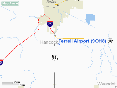
Location & QuickFacts
| FAA Information Effective: | 2008-09-25 |
| Airport Identifier: | 9OH8 |
| Airport Status: | Operational |
| Longitude/Latitude: | 083-38-29.7530W/40-58-35.1930N
-83.641598/40.976442 (Estimated) |
| Elevation: | 815 ft / 248.41 m (Estimated) |
| Land: | 0 acres |
| From nearest city: | 4 nautical miles SE of Findlay, OH |
| Location: | Hancock County, OH |
| Magnetic Variation: | 05W (1985) |
Owner & Manager
| Ownership: | Privately owned |
| Owner: | Robert Ferrell |
| Address: | 12432 Jackson Twp 168
Findlay, OH 45840 |
| Phone number: | 419-422-9394 |
| Address: |
|
Airport Operations and Facilities
| Airport Use: | Private |
| Wind indicator: | Yes |
| Segmented Circle: | No |
| Control Tower: | No |
| Landing fee charge: | No |
| Sectional chart: | Detroit |
| Region: | AGL - Great Lakes |
| Boundary ARTCC: | ZOB - Cleveland |
| Tie-in FSS: | CLE - Cleveland |
| FSS on Airport: | No |
| FSS Toll Free: | 1-800-WX-BRIEF |
Airport Services
| Airframe Repair: | NONE |
| Power Plant Repair: | NONE |
Runway Information
Runway N/S
| Dimension: | 2300 x 79 ft / 701.0 x 24.1 m |
| Surface: | TURF, |
| |
Runway N |
Runway S |
| Traffic Pattern: | Right | Right |
| Obstruction: | 30 ft pline, 300.0 ft from runway | 10 ft fence |
|
Radio Navigation Aids
| ID |
Type |
Name |
Ch |
Freq |
Var |
Dist |
| BNR | NDB | Benton Ridge | | 334.00 | 05W | 3.0 nm |
| PDR | NDB | Ottawa | | 233.00 | 05W | 15.5 nm |
| FZI | NDB | Fostoria | | 379.00 | 05W | 16.9 nm |
| TII | NDB | Tiffin | | 269.00 | 05W | 21.0 nm |
| LYL | NDB | Lima | | 362.00 | 04W | 23.8 nm |
| RUV | NDB | Rushsylvania | | 326.00 | 05W | 31.1 nm |
| MNN | NDB | Marion | | 201.00 | 05W | 33.8 nm |
| EDJ | NDB | Bellefontaine | | 242.00 | 05W | 37.2 nm |
| DFI | NDB | Defiance | | 246.00 | 05W | 41.5 nm |
| USE | NDB | Fulton | | 375.00 | 05W | 44.0 nm |
| VFU | NDB | Stanley | | 411.00 | 05W | 44.7 nm |
| MRT | NDB | Marysville | | 403.00 | 05W | 47.0 nm |
| PCW | NDB | Port Clinton | | 423.00 | 06W | 47.8 nm |
| BYN | NDB | Bryan | | 260.00 | 04W | 48.0 nm |
| DLZ | NDB | Delaware | | 215.00 | 06W | 48.7 nm |
| TOL | TACAN | Toledo | 072X | | 05W | 37.8 nm |
| MAH | VOR | Marathon | | 114.90 | 05W | 2.5 nm |
| AOH | VOR | Allen County | | 108.40 | 04W | 22.0 nm |
| BUD | VOR | Buckeye | | 109.80 | 05W | 34.0 nm |
| VWV | VOR/DME | Waterville | 078X | 113.10 | 02W | 28.6 nm |
| FDY | VORTAC | Findlay | 019X | 108.20 | 02W | 5.3 nm |
| ROD | VORTAC | Rosewood | 122X | 117.50 | 05W | 45.3 nm |
| MFD | VORTAC | Mansfield | 025X | 108.80 | 03W | 48.2 nm |
Remarks
- (A30-N/S) LANDING & TAKEFF TO THE NORTH.
- CONFLICT WITH FDY ARPT-TFC PATS CANNOT BE SEGREGATED.
Images and information placed above are from
http://www.airport-data.com/airport/9OH8/
We thank them for the data!
| General Info
|
| Country |
United States
|
| State |
OHIO
|
| FAA ID |
9OH8
|
| Latitude |
40-58-35.193N
|
| Longitude |
083-38-29.753W
|
| Elevation |
815 feet
|
| Near City |
FINDLAY
|
We don't guarantee the information is fresh and accurate. The data may
be wrong or outdated.
For more up-to-date information please refer to other sources.
|
|


