 |
|
| Fairfield County Airport |
| IATA: none – ICAO: KLHQ – FAA LID: LHQ |
| Summary |
| Airport type |
Public |
| Owner |
Fairfield County Commissioners |
| Serves |
Fairfield County |
| Location |
Lancaster, Ohio |
| Elevation AMSL |
868 ft / 265 m |
| Coordinates |
39°45′20″N 082°39′26″W / 39.75556°N 82.65722°W / 39.75556; -82.65722 |
| Website |
www.fairfieldair.com |
| Runways |
| Direction |
Length |
Surface |
| ft |
m |
| 10/28 |
5,004 |
1,525 |
Asphalt |
| Statistics (2009) |
| Aircraft operations |
43,066 |
| Based aircraft |
98 |
| Sources: FAA, airport website |
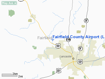
Fairfield County Airport (ICAO: KLHQ, FAA LID: LHQ) is a public use airport in Fairfield County, Ohio, United States. It is located three nautical miles (6 km) northwest of the central business district of Lancaster, the county seat. The airport is owned by the Fairfield County Commissioners.
Although most U.S. airports use the same three-letter location identifier for the FAA and IATA, this airport is assigned LHQ by the FAA but has no designation from the IATA.
Facilities and aircraft
Fairfield County Airport covers an area of 130 acres (53 ha) at an elevation of 868 feet (265 m) above mean sea level. It has one runway designated 10/28 with an asphalt surface measuring 5,004 by 75 feet (1,525 x 23 m).
For the 12-month period ending May 19, 2009, the airport had 43,066 aircraft operations, an average of 117 per day: 99.8% general aviation and 0.2% military. At that time there were 98 aircraft based at this airport: 85% single-engine, 7% multi-engine, 7% helicopter and 1% ultralight.
Currently there is one Standard Terminal Arrival (GUNNE ONE), an RNAV GPS approach in to runway 10 and 28, a localizer for 28 and a VOR or GPS-A circling approach.
Fairfield Air Ventures is the Fixed Base Operator which provides fuel, maintenance, flight instruction, charter flights, hangars and tie-downs, Lasergrade testing, WSI aviation weather and car rental.
In Spring of 2010, a plan was proposed to relocate Election House road, in an effort to allow larger aircraft to make use of the runway and allow the airport to add a global positioning system-aided landing system. The project is estimated to cost $1.3 million, with the FAA covering 95% of the costs, and other matching funds coming from Fairfield County.
The above content comes from Wikipedia and is published under free licenses – click here to read more.
Location & QuickFacts
| FAA Information Effective: | 2008-09-25 |
| Airport Identifier: | LHQ |
| Airport Status: | Operational |
| Longitude/Latitude: | 082-39-25.5457W/39-45-20.2983N
-82.657096/39.755638 (Estimated) |
| Elevation: | 868 ft / 264.57 m (Surveyed) |
| Land: | 130 acres |
| From nearest city: | 3 nautical miles NW of Lancaster, OH |
| Location: | Fairfield County, OH |
| Magnetic Variation: | 06W (1990) |
Owner & Manager
| Ownership: | Publicly owned |
| Owner: | Fairfield Co Commissioners |
| Address: | Fairfield County Courthouse
Lancaster, OH 43130 |
| Phone number: | 740-654-7001 |
| Manager: | Joe Mascari |
| Address: | 3430 Old Columbus Road
Carroll, OH 43112 |
| Phone number: | 740-654-7001 |
Airport Operations and Facilities
| Airport Use: | Open to public |
| Wind indicator: | Yes |
| Segmented Circle: | No |
| Control Tower: | No |
| Lighting Schedule: | DUSK-DAWN
MIRL RY 10/28 PRESET ON LOW INTST; TO INCR INTST & ACTVT REIL RYS 10 & 28 - 122.725. PAPI RY 28 OPER 24 HRS. |
| Beacon Color: | Clear-Green (lighted land airport) |
| Landing fee charge: | No |
| Sectional chart: | Cincinnati |
| Region: | AGL - Great Lakes |
| Boundary ARTCC: | ZID - Indianapolis |
| Tie-in FSS: | DAY - Dayton |
| FSS on Airport: | No |
| FSS Toll Free: | 1-800-WX-BRIEF |
| NOTAMs Facility: | LHQ (NOTAM-d service avaliable) |
| Federal Agreements: | NGY |
Airport Communications
| CTAF: | 122.725 |
| Unicom: | 122.725 |
Airport Services
| Fuel available: | 100LLA1+
FUEL AVBL 24 HRS WITH CREDIT CARD. |
| Airframe Repair: | MAJOR |
| Power Plant Repair: | MAJOR |
| Bottled Oxygen: | NONE |
| Bulk Oxygen: | NONE |
Runway Information
Runway 10/28
| Dimension: | 5004 x 75 ft / 1525.2 x 22.9 m |
| Surface: | ASPH, Good Condition |
| Weight Limit: | Single wheel: 25500 lbs.
Dual wheel: 38500 lbs. |
| Edge Lights: | Medium |
| |
Runway 10 |
Runway 28 |
| Longitude: | 082-39-57.4981W | 082-38-53.5937W |
| Latitude: | 39-45-22.0354N | 39-45-18.5587N |
| Elevation: | 857.00 ft | 868.00 ft |
| Alignment: | 94 | 127 |
| ILS Type: | | LOCALIZER
|
| Traffic Pattern: | Left | Left |
| Markings: | Non-precision instrument, Good Condition
RWY 10/28 MARKINGS POOR CONDITION - WEATHERED. | Non-precision instrument, Good Condition |
| Displaced threshold: | 0.00 ft | 279.00 ft |
| VASI: | 4-light PAPI on left side | 4-light PAPI on left side |
| Visual Glide Angle: | 3.00° | 3.00° |
| Runway End Identifier: | Yes | Yes |
| Obstruction: | 57 ft trees, 1082.0 ft from runway, 210 ft right of centerline, 15:1 slope to clear | 17 ft road, 265.0 ft from runway, 250 ft right of centerline, 3:1 slope to clear
RWY 28 APCH RATIO 20:1 TO DISPLACED THRESHOLD. |
|
Radio Navigation Aids
| ID |
Type |
Name |
Ch |
Freq |
Var |
Dist |
| CM | NDB | Sumie | | 391.00 | 05W | 14.6 nm |
| HEH | NDB | Newark | | 524.00 | 06W | 18.5 nm |
| CYO | NDB | Circleville | | 366.00 | 05W | 20.5 nm |
| CHC | NDB | Grens | | 272.00 | 04W | 23.0 nm |
| BU | NDB | Boutn | | 230.00 | 05W | 25.6 nm |
| RZT | NDB | Ross County | | 236.00 | 05W | 25.7 nm |
| DKG | NDB | Don Scott | | 348.00 | 05W | 27.6 nm |
| OS | NDB | Fuler | | 515.00 | 05W | 31.4 nm |
| CSS | NDB | Court House | | 414.00 | 05W | 35.2 nm |
| HRA | NDB | Zanesville | | 204.00 | 06W | 35.2 nm |
| DLZ | NDB | Delaware | | 215.00 | 06W | 37.5 nm |
| EOP | NDB | Waverly | | 385.00 | 06W | 37.6 nm |
| UGS | NDB | University | | 250.00 | 06W | 38.8 nm |
| UYF | NDB | London | | 263.00 | 06W | 38.8 nm |
| MRT | NDB | Marysville | | 403.00 | 05W | 42.6 nm |
| LCK | TACAN | Rickenbacker | 069X | | 05W | 12.9 nm |
| XUB | VOR | Yellow Bud | | 112.50 | 05W | 20.2 nm |
| ZZV | VOR/DME | Zanesville | 051X | 111.40 | 06W | 37.0 nm |
| TVT | VOR/DME | Tiverton | 112X | 116.50 | 03W | 48.8 nm |
| APE | VORTAC | Appleton | 114X | 116.70 | 06W | 24.0 nm |
| CMH | VOT | Port Columbus | | 111.00 | | 17.8 nm |
Remarks
- RY 28 CALM WIND PREFERED RY.
- RUN UP AREA N END RY 28 CLSD PERMLY.
Images and information placed above are from
http://www.airport-data.com/airport/LHQ/
We thank them for the data!
| General Info
|
| Country |
United States
|
| State |
OHIO
|
| FAA ID |
LHQ
|
| Latitude |
39-45-20.330N
|
| Longitude |
082-39-25.596W
|
| Elevation |
869 feet
|
| Near City |
LANCASTER
|
We don't guarantee the information is fresh and accurate. The data may
be wrong or outdated.
For more up-to-date information please refer to other sources.
|
|


