 |
|
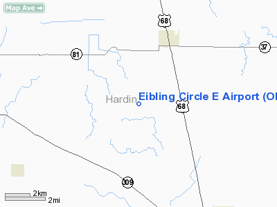
Location & QuickFacts
| FAA Information Effective: | 2008-09-25 |
| Airport Identifier: | OI66 |
| Airport Status: | Operational |
| Longitude/Latitude: | 083-40-15.7520W/40-44-27.1920N
-83.671042/40.740887 (Estimated) |
| Elevation: | 980 ft / 298.70 m (Estimated) |
| Land: | 3 acres |
| From nearest city: | 3 nautical miles SE of Dola, OH |
| Location: | Hardin County, OH |
| Magnetic Variation: | 05W (1985) |
Owner & Manager
| Ownership: | Privately owned |
| Owner: | Vivian Eibling |
| Address: | 5882 Twp Rd 125
Kenton, OH 43326 |
| Phone number: | 419-759-2094 |
| Manager: | Thomas R. Eibling |
| Address: | 11066 County Rd. 60
Dola, OH 45835 |
| Phone number: | 419-759-2094 |
Airport Operations and Facilities
| Airport Use: | Private |
| Wind indicator: | Yes |
| Segmented Circle: | No |
| Control Tower: | No |
| Landing fee charge: | No |
| Sectional chart: | Detroit |
| Region: | AGL - Great Lakes |
| Boundary ARTCC: | ZID - Indianapolis |
| Tie-in FSS: | DAY - Dayton |
| FSS on Airport: | No |
| FSS Toll Free: | 1-800-WX-BRIEF |
Runway Information
Runway 18/36
| Dimension: | 2300 x 38 ft / 701.0 x 11.6 m |
| Surface: | TURF, |
| |
Runway 18 |
Runway 36 |
| Traffic Pattern: | Left | Left |
| Obstruction: | 80 ft bldg, 400.0 ft from runway, 400 ft left of centerline | 32 ft pline |
|
Radio Navigation Aids
| ID |
Type |
Name |
Ch |
Freq |
Var |
Dist |
| LYL | NDB | Lima | | 362.00 | 04W | 16.2 nm |
| BNR | NDB | Benton Ridge | | 334.00 | 05W | 16.8 nm |
| RUV | NDB | Rushsylvania | | 326.00 | 05W | 16.9 nm |
| PDR | NDB | Ottawa | | 233.00 | 05W | 22.3 nm |
| EDJ | NDB | Bellefontaine | | 242.00 | 05W | 23.2 nm |
| MNN | NDB | Marion | | 201.00 | 05W | 28.4 nm |
| FZI | NDB | Fostoria | | 379.00 | 05W | 29.7 nm |
| TII | NDB | Tiffin | | 269.00 | 05W | 30.1 nm |
| MRT | NDB | Marysville | | 403.00 | 05W | 34.2 nm |
| DLZ | NDB | Delaware | | 215.00 | 06W | 38.1 nm |
| VFU | NDB | Stanley | | 411.00 | 05W | 43.5 nm |
| CQA | NDB | Lakefield | | 205.00 | 04W | 43.6 nm |
| OS | NDB | Fuler | | 515.00 | 05W | 45.6 nm |
| DKG | NDB | Don Scott | | 348.00 | 05W | 48.1 nm |
| UYF | NDB | London | | 263.00 | 06W | 49.4 nm |
| DFI | NDB | Defiance | | 246.00 | 05W | 49.5 nm |
| AOH | VOR | Allen County | | 108.40 | 04W | 13.7 nm |
| MAH | VOR | Marathon | | 114.90 | 05W | 16.5 nm |
| BUD | VOR | Buckeye | | 109.80 | 05W | 28.7 nm |
| VWV | VOR/DME | Waterville | 078X | 113.10 | 02W | 42.7 nm |
| FDY | VORTAC | Findlay | 019X | 108.20 | 02W | 13.5 nm |
| ROD | VORTAC | Rosewood | 122X | 117.50 | 05W | 32.1 nm |
| MFD | VORTAC | Mansfield | 025X | 108.80 | 03W | 49.7 nm |
Remarks
- RWY OUTLINED WITH HAY 30 FT FROM RWY EDGES.
Images and information placed above are from
http://www.airport-data.com/airport/OI66/
We thank them for the data!
| General Info
|
| Country |
United States
|
| State |
OHIO
|
| FAA ID |
OI66
|
| Latitude |
40-44-27.192N
|
| Longitude |
083-40-15.752W
|
| Elevation |
980 feet
|
| Near City |
DOLA
|
We don't guarantee the information is fresh and accurate. The data may
be wrong or outdated.
For more up-to-date information please refer to other sources.
|
|


