 |
|
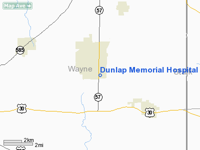
Dunlap Memorial Hospital Heliport |
Location & QuickFacts
| FAA Information Effective: | 2008-09-25 |
| Airport Identifier: | 8OH1 |
| Airport Status: | Operational |
| Longitude/Latitude: | 081-45-43.4750W/40-49-57.1990N
-81.762076/40.832555 (Estimated) |
| Elevation: | 1124 ft / 342.60 m (Estimated) |
| Land: | 0 acres |
| From nearest city: | 0 nautical miles N of Orrville, OH |
| Location: | Wayne County, OH |
| Magnetic Variation: | 07W (1990) |
Owner & Manager
| Ownership: | Privately owned |
| Owner: | Orrville Hospital Foundation |
| Address: | 832 S Main St
Orrville, OH 44691 |
| Phone number: | 216-682-3010 |
| Address: |
|
Airport Operations and Facilities
| Airport Use: | Private
MEDICAL USE. |
| Segmented Circle: | No |
| Control Tower: | No |
| Sectional chart: | Detroit |
| Region: | AGL - Great Lakes |
| Boundary ARTCC: | ZOB - Cleveland |
| Tie-in FSS: | CLE - Cleveland |
| FSS Toll Free: | 1-800-WX-BRIEF |
Runway Information
Helipad H1
| Dimension: | 65 x 65 ft / 19.8 x 19.8 m |
| Surface: | ASPH, |
| |
Runway H1 |
Runway |
| Traffic Pattern: | Left | Left |
|
Radio Navigation Aids
| ID |
Type |
Name |
Ch |
Freq |
Var |
Dist |
| MLR | NDB | Millersburg/dcmsnd | | 382.00 | 06W | 18.2 nm |
| AK | NDB | Akron | | 362.00 | 07W | 22.2 nm |
| AAU | NDB | Ashland | | 329.00 | 07W | 23.7 nm |
| MF | NDB | Manns | | 372.00 | 06W | 31.3 nm |
| CL | NDB | Harri | | 344.00 | 07W | 31.8 nm |
| TSO | NDB | Tolson | | 395.00 | 07W | 35.2 nm |
| EZE | NDB | Engel | | 226.00 | 07W | 39.5 nm |
| BKL | NDB | Burke Lakefront | | 416.00 | 07W | 42.1 nm |
| CFX | NDB | Cadiz | | 239.00 | 07W | 49.5 nm |
| BSV | VOR/DME | Briggs | 071X | 112.40 | 04W | 16.0 nm |
| TVT | VOR/DME | Tiverton | 112X | 116.50 | 03W | 28.0 nm |
| ACO | VOR/DME | Akron | 091X | 114.40 | 04W | 30.4 nm |
| DJB | VOR/DME | Dryer | 083X | 113.60 | 05W | 36.4 nm |
| CTW | VOR/DME | Newcomerstown | 055X | 111.80 | 07W | 38.5 nm |
| CXR | VOR/DME | Chardon | 074X | 112.70 | 05W | 49.3 nm |
| MFD | VORTAC | Mansfield | 025X | 108.80 | 03W | 37.7 nm |
| CAK | VOT | Akron/canton Regional | | 110.60 | | 15.4 nm |
| CLE | VOT | Cleveland | | 110.40 | | 35.0 nm |
Remarks
- PRVDD APCH/DEP RTE OPS FM 70 TO 180; TKOF/LDG AREA IS MKD & ONE OF THE 1200 WATT HDS LGTS ON A 24' POLE BE REMOVED; TWO 7' TREES SE & S SHOULD BE RELOCATED OR REMOVED; A WIND IND IS MAINTAINED.
Images and information placed above are from
http://www.airport-data.com/airport/8OH1/
We thank them for the data!
| General Info
|
| Country |
United States
|
| State |
OHIO
|
| FAA ID |
8OH1
|
| Latitude |
40-49-57.199N
|
| Longitude |
081-45-43.475W
|
| Elevation |
1124 feet
|
| Near City |
ORRVILLE
|
We don't guarantee the information is fresh and accurate. The data may
be wrong or outdated.
For more up-to-date information please refer to other sources.
|
|


